Parcel
|
|
The Outlett
|
PDO
|
Abstract
|
| 87-00974-03 |
October
10, 1695: Nicholas and Josias Massey patent 110 acres, called The Outlett, out of a 1,000 acre
tract granted to John Taylor the previous year. Acting for the
Crown: Henry Darnall ... [the deed is incomplete - GL,III, ed.]
|
|
Massey's Hazard
|
PDO
|
Abstract
|
| 87-0311-24 |
July
8, 1702: Nicholas Massey's patent of Massey's
Hazard, a 90 acre portion of a 1,000 acre tract in Kent County,
Maryland, and adjoining land formerly of Simon Gillmore. Deputy
Surveyor for the county: Daniel Baes.
|
| 87-0311-25 |
July
8, 1702: Nicholas Massey's patent of Massey's
Hazard, a 90 acre portion of a 1,000 acre tract granted to
Daniel Toaos [Toaes] in Kent County, Maryland. Acting for the
Crown: Henry Darnell.
|
| 87-0311-15 |
March
3, 1745: Peter Massey, Jr. of Kent County in Maryland for 6,200 pounds
of tobacco buys a 140 acre tract of land called Johnson's Adventure with Massey's Hazard
from Peter Massey, Sr. planter, and wife Jane, Nicholas Massey,
planter, and wife Katherine, and James Massey and wife Rachel.
Witnesses: James Brown, and H. Wells, Jr. Acting for the Crown:
[illegible] Tilghman.
|
|
London Bridge
|
PDO
|
Abstract
|
| 87-0311-47 |
May
12, 1709: Sarah (nee Toaes or Toas, whose father was Daniel) Massey,
bride of Peter Massey, of Kent County in Maryland inherits a 350 acre
parcel called London Bridge
from John Toaes (Toas) son of Daniel Toas and represented by Andrew
Hamilton, Esquire. Witnesses: Harry Clegg and John
[illegible]. Acting for the Crown: Harry Hopkins and William
Lott; James Smith, Kent County Clerk.
|
| 87-0311-42 |
May
15, 1712 (recorded May 13, 1713): John Clark, planter, of Kent County
in Maryland, buys for 1,000 pounds of tobacco the entirety of a 50 acre
parcel called London Bridge
from Peter Massey, planter, and wife Sarah (accompanied by William
Comegys, Esquire). Witnesses: William Comegys and Edward E.
Nickaros. Acting for the Crown: Edward [illegible], W. Lott;
James Smith, Kent County Court Clerk.
|
Certificate
128
|
January
1, 1753: London Bridge Renewed, Daniel Massey, 710 Acres. Unpatented.
|
Patent
329
|
August
8, 1754: London Bridge Renewed, Daniel Massey, 710 Acres. |
| 87-0311-36 |
June
9, 1758: Henry Clark, planter, of Kent County in Maryland buys for 20
pounds (paid to Peter Massey, father of Daniel) a 50 acre parcel called
London Bridge (Renewed)
from Daniel Massey and wife Mary. Witnesses: J. Wilmer, Nicholas
Smith. Acting for the Crown: Joseph Nicholson; James Smith, Kent
County Clerk.
|
DD:1:563
|
February 18, 1764: Daniel Massey, planter of
Kent County in Maryland, sells for £20 a 7-1/2 acre portion plus
another 37 acre parcel of London
Bridge
Renewed to Thomas Gilpin, also of Kent County. Courses for
the larger London Bridge Renewed tract: Beginning at a black oak
sapling marked with twelve notches, standing near where a line running
North West of the tract called London Bridge Renewed intersects the
North side of said Gilpin's mill race that leads the water from his
Cypress Dam to his mill, thence South East until it intersects the East
side of the said Gilpin's Condemned Land on the East side of the
Cypress Branch, being forty perches, thence North seventeen degrees
East sixteen perches, thence North eleven degrees East twelve perches,
thence North fifty degrees West six perches, thence West four perches,
being with the Condemned Land to where it intersects the East side of
the mill pond, thence up the mill pond on the East side until it
intersects the aforesaid Gilpin's land lot of John Jones, thence North
West to the South West corner thereof, thence North East fifty five
perches, thence North West to the West side of the mill pond, being
twenty eight perches thence [illegible] the pond according to the
several courses of the West side thereof until it comes to where the
first beginning black oak bears South seventeen degrees West, thence
with a straight line to the beginning, containing thirty two acres. And
for the smaller parcel: Beginning where the above land intersects the
East side of the said Gilpin's little mill pond, thence Northwardly up
the East side thereof as far as the pond arises, thence across to the
West side thereof, thence down the West side thereof until the first
beginning, bears South East, thence with a straight line to the
beginning, containing seven and a half acres. Both parcels now
conveyed by Daniel Massey to Thomas Gilpin total thirty nine and one
half acres. Acting for the Crown: J. Nicholson and Justices of the
Peace James Pearce and John Eccleston; Dennis Dulany is Kent County
clerk. |
| 87-0311-37 |
February 18,
1764 (recorded March 5, 1764): Thomas Gilpin, merchant of Philadelphia,
for the quantity of 39.5 acres of land, part of a tract called London Bridge Renewed, sells to
Daniel Massey of Kent County in Maryland all of the 37 acre tract of
land called Hall's Harbour and
Bridge Sound Commons. Testes: James Pearce. Acting
for the Crown: Justices of the Peace James Pearce and [illegible]
Eccleston; Joseph Nicholson; and Daniel Dulany, Kent County Clerk.
|
| 87-0311-39 |
August
8, 1765: Gilbert Falconar, farmer, of Kent County in Maryland buys for
50 pounds a 300 acre parcel called London
Bridge Renewed (adjacent to Honberry,
owned by Humphrey Davenport) from Daniel Massey, gentleman, and wife
Mary. Acting for the Crown: James McLachlan and Samuel Thompson;
John Nicholson; and Dennis Dulany, Kent County Clerk.
|
DD:2:388
|
March 17, 1767: Luke Miers
(Myers), farmer of Kent County in Maryland, buys for £52 two tracts of
Kent County land: 37 acres of London
Bridge Renewed (part of a tract bought from John Jones by Mr.
Gilpin) and 20+ acres of McDugils
Chance
(which Mr. Gilpin bought from Henry Clark), from Thomas Gilpin,
merchant of the City of Philadelphia. Courses for London Bridge
Renewed: Beginning at the North West corner of London Bridge Renewed
and running South West fifty five perches, then North West one hundred
and twelve perches, then North sixty nine degrees East thirty seven
perches, then North ten degrees East twenty eight perches, then South
East to the beginning. Courses for McDugils Chance (or Pond
Side): Beginning at the South East corner of McDugil's Chance and
running thence North twenty nine degrees East twenty perches, then
North thirty three degrees West thirty five perches, then North East
two perches, then North West ninety three perches, then South West
twenty seven perches, then South East to the beginning. Acting for the
Crown: J.W. Hall and Justices of the Peace James McLachlan and Samuel
Thompson; Dennis Dulany is Kent County clerk. |
DD:4:205
|
September 2, 1773: Lambert Massey of Kent
County in Maryland buys for "rents, covenants and agreements" a part of
London
Bridge Renewed from Gilbert Falconar, planter, also of Kent
County. Courses: Beginning at a marked white oak post and running
from thence North seventy eight degrees West twenty perches, then North
twelve degrees East thirty three perches, thence South seventy eight
degrees East twenty perches, and thence with a straight line to the
beginning. Tenure of Lambert Massey and his heirs is to be thirty years
at a yearly rent of £4 Pennsylvania money; and Lambert is not to "sell,
dispose or traffic any wet or dry goods, excepting iron and wood."
Acting for the Crown: Justices of the Peace J. Maxwell and James
Hynson; Dennis Dulany is Kent County clerk. |
EF:7:173
|
June 21, 1787: Abraham Falconar of Queen
Anne's County in the State of Maryland sells for £600 a 3-1/2 acre
portion of London
Bridge Renewed,
lying in Bridgetown, Kent County, to Stephen Massey of Kent County.
Courses: Beginning at a stake [illegible] the dividing line between
Gilbert Falconar's land and that of the heirs of Thomas Gilpin,
deceased, crosses the Duck Creek Road and in the middle thereof running
thence North seventy eight degrees West ten perches to a lot leased by
Gilbert Falconar to a certain Lambert Massey, thence North twelve
degrees East thirty nine perches, thence North seventy eight degrees
West twenty perches, thence North twelve degrees East to the land
belonging to the heirs of Thomas Gilpin, thence South seventy six
degrees Est thirty three perches more or less to the old divisor line
between Gilbert Falconar and the heirs of Thomas Gilpin, thence along
and with the said boundary South unto the beginning. Witnesses:
Justices of the Peace John Woodland and John Thomas; Ben Chambers is
Kent County clerk. |
EF:7:212
|
October 3, 1787: Ebenezer Massey of Kent
County in the State of Maryland buys for 5/- from Gilbert Falconar,
also of Kent County, all of the tract called Partnership which lies
within the lines of two tracts of land, the property of Ebenezer
Massey, called Masseys
Venture
Resurveyed and [The] Exchange, also all that tract of land called
Partnership which lies to the Eastward of James Hynson's lines,
the whole breadth of the two tracts of land called Masseys Venture
resurveyed and [The] Exchange, and also all that part of the aforesaid
tract called Partnership, and that part of four other tracts of land
called London
Bridge Renewed which
lie to the eastward of the road leading from the Head of Chester to the
Head of Sassafras iver, and to the Northward of the Long Meadow Branch
as far up as Luke Miers line. Witnesses: Justices of the Peace James
Henry and John Thomas; Ben Chambers is Kent County clerk. |
TW:1:194
|
May 18, 1799: Daniel Massey of Kent County
in the State of Maryland sells for £164, 10/, portions of London
Bridge Renewed and Halls
Harbours, totaling 94 acres, to John Greenwood of Queen Anne's County.
Courses for the part of London Bridge Renewed: Beginning at the end of
fifty perches on the fifth line of London Bridge Renewed, and running
thence with that line eighty three and one third perches, and North
West eighty three perches, and North eleven and three quarters degrees
East twenty six perches, and North eleven degrees West sixty four
perches, and North seventy and one half degrees East twenty nine
perches, and South eighty five degrees East two perches,, and from
thence with a straight line to the beginning, containing sixty five
acres. Courses for the part of Halls Harbour, adjoining:
Beginning where the South East or North West line of said Massey's land
crosses the East side bounding line of the Condemned Land of the Mill
of Thomas Gilpin, and running from thence South thirty seven degrees
West eighty two perches, then South sixty nine degrees East forty four
perches, then South twenty eight degrees East sixteen perches, then
North sixty two degrees East seventy perches, and from thence with a
straight line to the beginning, containing twenty nine acres.
Witnesses: Justices of the Peace John Thomas and James Parker; Thomas
Worrell is Kent County clerk. |
TW:1:363
|
March 22, 1800: Daniel Massey, gentleman of
Kent County in the State of Maryland sells for £1,227 a 204-1/2 acre
portion of London
Bridge Renewed to
John Comegys and wife Elizabeth, also of Kent County. Courses:
Beginning at a stone standing at or near the end of the first line of a
tract of land described by a deed of salefrom Daniel Massey and wife
(since deceased) to Gilbert Falconar (since deceased) and running from
said stone North forty six and one half degrees East sixty four
perches, then North twenty eight and one quarter degrees East twenty
perches, then North twenty four degrees East twelve perches, then North
fourteen and three quarter degrees East thirty four perches, then North
forty four and a half degrees East twenty five perches to the South
East line of the original tract of land called London Bridge Renewed,
then with that line South forty eight degrees East two hundred and
thirty two perches to Gilpin's Mill Pond, then down by and with the
said Mill Pond South fifty one and three quarter degrees West nineteen
perches, then South six and three quarter degrees West six perches,
then South twenty one degrees East eleven perches, then South thirty
seven and a half degrees West eight perches, then South eighty degrees
West fourteen perches, then North Seventy six and a half degrees West
eight perches, then South thirty degrees West fifty two perches, then
South twenty six degrees East fifty four perches, then South forty two
and three quarter degrees East eight perches to the Mill Race, then
South sixty seven and a half degrees West sixteen perches, then North
forty eight degrees West fifty five and a half perches to the Little
Mill Pond, then up, by and with the same North four degrees West twelve
perches, then North seventy one degrees West eleven perches, then North
forty six and a half degrees East nineteen perches, then North eleven
and three quarter degrees West fourteen perches, then North fifty three
and a quarter degrees West eight perches, then North sixteen degrees
West sixteen perches, then North nine degrees East four perches, then
North sixteen and three quarter degrees West eight and a quarter
perches to a white oak standing by the side of the said pond, then
across the said pond South seventy two and three quarter degrees West
sixteen and a quarter perches, then down the said pond on the West side
thereof and binding with the same South sixty two and a half degrees
East twelve perches, then South fourteen and three quarter degrees West
fourteen perches, then South six degrees East sixteen perches, then
South thirty nine and a half degrees East sixteen perches, then South
fifty five degrees West twenty five and one third perches to the second
line of the said tract described by the said Deed from the said Daniel
Massey and wife (since deceased) to the said Gilbert Falconar (since
deceased) and then with that line to the aforesaid place of beginning.
A thirty square foot burial plot is reserved for the family of Daniel
Massey and is excepted. Witnesses: Justices of the Peace James Parker
and John Hurtt; Thomas Worrell is Kent County clerk. |
BC:6:202
|
August
31, 1810: George Reynolds Massey, gentleman of New Castle County in the
State of Delaware, sells a 3 acre portion of London
Bridge Renewed in Bridge Town,
Kent County, Maryland for $200.00 to Doctor John Thomas of Kent County
in the State of Maryland. Courses, bounded by the following lots and
parcels: On the South bounded by the Publick Road leading from Smyrna
to Popes Landing on the Chester River, adjoining to and on the North
side of said road, and running by and with the most Southerly line of a
lot sold by Gilbert Falconar to Helathiel [spelling ? - GL,III,ed.]
Ireland and including what is known as Irelands Lot, bounded on the
West by land deeded by Gilbert Falconar to Isaac Spencer, bounded on
the North by a parcel swold by Gilbert Falconar to Thomas Gilpin,
and on the East by ground conveyed by Gilbert Falconar to Abraham
Falconar and William Miers, containing three acres. Witnesses:
Cornelius Comegys and Benjamin Massey; Ben Chambers is Kent County
clerk. |
TW:4:282
|
July
28, 1823: Benjamin Comegys and wife Ellen, both of Kent County in the
State of Maryland, swell for $1,090.00 a 204-1/2 acre portion of London
Bridge Renewed to John Turner,
Junior, also of Kent County. Courses: Beginning at a stone standing at
or near the end of the first line of a tract of line described by the
deed of sale from Daniel Massey and wife, since deceased, to Gilbert
Falconar, also since deceased, and running from said stone North forty
six and a half degrees East sixty four perches, then North twenty four
degrees East twelve perches, then North fourteen and three quarter
degrees East thirty four perches, then North forty four and a half
degrees East twenty five perches to the line of the original tract of
land called London Bridge Renewed, and then with that line South forty
eight degrees East two hundred and thirty two perches to Gilpins mill
pond, then down by and with the said mill pond, South fifty one and
three quarter degrees West nineteen perches, then South six and three
quarters degrees West six perches, then South twenty one degrees East
eleven perches, then South thirty seven and a half degrees West eight
perches, then South eighty degrees West fourteen perches, then North
seventy six and a half degrees West eight perches, then South thirty
degrees West fifty two perches, then South twenty six degrees East
fifty four perches, then South forty two and three quarter degrees East
eight perches to the mill race, then South sixty seven and a half
degrees West sixteen perches, then North forty eight degrees West fifty
five and a half perches to the little mill pond, then up by and with
the same North four degrees West, twelve perches, then North
seventy one degrees West eleven perches, then North forty six and
a half degrees East nine perches, then North fifteen degrees East
nineteen perches, then North eleven [illegible last line of page 282] and
three quarter degrees West fourteen perches, then
North fifty three and one quarter degrees West eight perches, then
North sixteen degrees West sixteen perches, then North nine degrees
East four perches, then North sixteen and three quarter degrees West
eight and a quarter perches, to a white oak tree standing by the side
of the said pond, then across the said pond, South seventy two and
three quarter degrees West sixteen and a half perches, then down the
said pond on the West side thereof and binding with the same South
sixty two and a half degrees East twelve perches, then South fourteen
and three quarter degrees West fourteen perches, then South six degrees
East sixteen perches, then South thirty nine and a half degrees East
sixteen perches, then South fifty five degrees West twenty five and a
third perches to the second line of the said Daniel Massey-Gilbert
Falconar land deed, and then with the said line to the aforesaid place
of beginning, now laid out for two hundred and four and a half acres,
excepting thirty square feet laid out for Daniel Massey and heirs
[as a burial ground - GL,III,ed.] Witnesses: Justices of the Peace
Michael Smith and John McDaniel; Thomas Worrell is Kent County clerk. |
JNG:3:354
|
March 18, 1834: Mary Thomas of Kent County
in the State of Maryland sells for $2,000.00 to Ebenezer T. Massey part
of the parcel called London
Bridge Renewed,
which was conveyed by Ann Thomas to James Parker and Catherine Parker,
his wife, with provisions in favor of Catherine, reference being to the
deed dated July 11,1827 and to her Will of the same date.
Witnesses: Justices of the Peace John McDaniel and William Millan;
Joseph N. Gordon is Kent County clerk. |
TW:4:410
|
May
8, 1834: Joseph Wright and wife Ann Eliza Wright, both of Kent County
in the State of Maryland, sell for $1,090.00 to John Turner, Junior,
also of Kent County a portion of the tract called London
Bridge Renewed that is contained
within the following metes and bounds: Beginning at a stone at or near
the end of the first line of a tract the deed between Daniel Massey and
wife, sonce deceased, to Gilbert Falconar, also deceased, and running
from said stone North forty six and a half degrees East sixty four
perches, then North twenty eight and a quarter degrees East twenty
perches, then North twenty four degrees East twelve perches, then North
fourteen and three quarter degrees East twenty five perches to the line
of the original tract called London Bridge Renewed, and then with that
line South forty eight degrees East two hundred and thirty two perches
to Gilpin's Mill Pond, then down by and with the said mill pond [South]
fifty one and three quarter degrees West nineteen perches, then South
six and three quarter degrees West sixteen perches, then South twenty
one degrees East eleven perches, then South thirty seven and a half
degrees West eight perches, then South eighty degrees West fourteen
perches, then North twenty six and a half degrees West Eight
perches, then South thirty degrees West fifty two perches, then South
twenty six degrees East fifty four perches, then South forty two and
three quarter degrees East eight perches to the mill race, then South
sixty seven and a half degrees West sixteen perches, then North forty
eight degrees West fifty five and a half perches to the little mill
pond, then up by and with the same North four degrees West twelve
perches, then North seventy one degrees West eleven perches, then North
forty six and a half degrees East nine perches, then North fifteen
degrees East nineteen perches, then North eleven and a quarter degrees
West fourteen perches, then North fifty three and a quarter degrees
West eight perches, then North sixteen degrees West sixteen perches,
then North nine degrees East four perches, then North sixteen and three
quarter degrees West eight and a quarter perches to a white oak tree
standing by the side of of the said pond, then across the pond South
seventy two and three quarter degrees West sixteen and a half perches,
then down the said pond on the West side thereof and bending with the
same South sixty two and a half degrees East twelve perches, then South
fourteen and three quarter degrees West fourteen perches, then South
six degrees East sixteen perches, then South thirty nine and a half
degrees East sixteen perches, then South fifty five degrees West twenty
five and a third perches to the second line of the tract described in
the Daniel Massey and wife deed, and then with the said line to the
place of beginning, containing two hundred and four and a half acres.
Excepted [still ! - GL,III, ed.] are thirty square feet of ground
reserved to Daniel Massey and his heirs. Witnesses: Justices of the
Peace Michael Smith and John McDaniel. Thomas Worrell is Kent County
clerk. |
JT:2:202
|
April 6, 1837: Elijah E. Massey
of Millington in Queen Anne's County in the State of Maryland sells for
$450.00 to Juliett Duhamel of Queen Anne's County a 0.1 acre town lot
from the tract called London Bridge Renewed, lying in Sand Town, Queen
Anne's County, within the following metes and bounds: Beginning at a
stone standing on the East side of the road that leads from Millington
to Church Hill and running South forty nine degrees West sixty six
feet, then South East to the division line between the heirs of Thomas
Gilpin and the late Gilbert Falconar, then North East sixty six feet,
then North West to the beginning at the aforesaid stone, being the lot
in Sand Town formerly conveyed by Gilbert Falconar to William Knock.
Witnesses: Justices of the Peace Thomas J. Britton and William Colgan.
|
JT:2:551
|
May
6, 1839: Ebenezer T. Massey of Kent County in the State of
Maryland buys for $880.00 from Thomas Gilpin of Brandywine Delaware a
part of two large tracts in Queen Anne's County called London Bridge
and Hall's Harbor which is on the South side of Chester River and on
the East side of Sand Town and described by the following courses:
Beginning at the beginning stone of Hall's Harbor and running thence in
the line thereof South forty six degrees East one hundred and twenty
two perches and twenty four parts to a corner on the said line of a
tract sold by the said Thomas Gilpin to John E. Stuart, thence with a
line thereof North forty four degrees East one hundred and seventeen
perches to a corner on a line of land of James Brown, thence with a
line thereof North sixty four and a half degrees West six perches to a
poplar corner, thence North seventeen and a half degrees West twenty
three perches to a poplar corner, thence North forty four degrees East
with the said James Brown's line twenty perches to Chesster River, and
then to be bounded on the North side of this tract by the same by the
several courses of the said river, until where it is intersected by a
line bounding the several lots of the said Sand Town lying on the East
side of the said road or street, thence from the said intersection on
Chester River by a line running South forty two degrees West fifty
eight perches along and bounding the Easternmost end of the said
several lots as held in Sand Town, by the several [illegible phrase]
till it comes to a line of London Bridge, thence with the same North
forty five and three quarter degrees West twenty and a half perches to
[illegible place name] thence with the same South eight and a quarter
degrees West about ninety two perches, thence North forty four degrees
East twenty four perches to the beginning stone, containing one hundred
and ten acres. Also the said Thomas Gilpin includes in the
conveyance an access lot from the said road, twenty feet wide along the
East side of Hall's Harbor on the course of South forty six degrees
East one hundred and twenty two perches to John E. Stuart's land and
from the beginning stone of Hall's Harbor out to the public road of
Queen Anne's County. Witnesses: Justices of the Peace William Colgan
and Thomas J. Britton.
|
JNG:7:460
|
July
24, 1841: John C. Turner and wife of the City of Baltimore in the State
of Maryland sell one undivided ninth part of London
Bridge Renewed for $500.00 to
Janett T. Rasin of Millington in Kent County. Courses: Beginning
at a stone standing at or near the end of the first line of a tract of
land described in a deed from Daniel Massey and wife, since deceased,
to Gilbert Falconar, also deceased, and running from said stone North
forty six and a half degrees East sixty four perches, then North twenty
eight and a quarter degrees East twenty perches, then North twenty four
degrees East twelve perches, then North fourteen and three quarter
degrees East thirty four perches, then North forty four and a half
degrees East twenty five perches to the line of the original tract of
land called London Bridge Renewed, and then with that line South forty
eight degrees East two hundred and thirty two perches to Gilpin's mill
pond, then down, by and with the said mill pond South fifty one and
three quarter degrees West nineteen perches, then South six and three
quarter degrees West six perches, then South twenty one degrees East
eleven perches, then South thirty seven and a half degrees West eight
perches, then South eighty degrees West fourteen perches, then North
seventy six and a half degrees West eight perches, then South thirty
segrees West fifty two perches, then South twenty six degrees East
fifty four perches, then South forty two and three quarter degrees East
eight perches to the mill race, then South sixty seven and a half
degrees West sixteen perches, then North forty eight degrees West fifty
five and a half perches to the little mill pond, then up, by and with
the same, North four degrees West twelve perches, then North seventy
one degrees West eleven perches, then North forty six and a half
degrees East nine perches, then North fifteen degrees East nineteen
perches, then North eleven and [three] quarter degrees West fourteen
perches, then North fifty three and a quarter degrees West eight
perches, then North sixteen degrees West sixteen perches, then North
nine degrees East four perches, then North sixteen and three quarter
degrees West eight and a quarter perches to a white oak standing by the
side of said pond, then across the said pond, South seventy two and
three quarter degrees West sixteen and a half perches, then down and
with said pond on the West side thereof and binding with the same,
South sixty two and a half degrees East twelve perches, then South
fourteen and three quarter degrees West fourteen perches, then South
six degrees East sixteen perches, then South thirty nine and a half
degrees East sixteen perches, then South fifty five degrees West twenty
five and a third perches to the second line of said tract of land
described by said deed of sale from Daniel Massey and wife since
deceased, and then with the said line to the aforesaid place of
beginning, containing two hundred and four and a half acres. Witnesses:
Justices of the Peace for the City of Baltimore A.H. Pennington and
Henry W. Gray; and Thomas Hall, Baltimore County clerk; Joseph N.
Gordon is Kent County clerk. |
JP:1:17
|
February 3, 1852: Ebenezer T. Massey of Kent
County in the State of Maryland sells for $2,000.00 to Mary E. Massey
of Queen Anne's County, the Queen Anne's County tracts called (1)
London Bridge, that lies on the South side of Chester River and partly
adjoining on the East side of Sand Town, being part of his large tract
of land severally called London Bridge and Halls Harbour and is
contained within the following metes and bounds: Beginning at the
beginning stone of Halls Harbour and running thence in the line
thereof, South fifty six degrees East one hundred and twenty two
perches [and twenty four parts ?] to a corner on the said line of a
tract sold by Thomas Gilpin to John E. Stewart, thence with a line
thereof North fifty four degrees East one hundred and seventeen perches
to a corner on a line of land of James Brown, thence with a line
thereof North sixty four and a half degrees West six perches to a
poplar corner, thence North seventeen and a half degrees West twenty
three perches to a poplar corner, thence North forty four degrees East
with the said James Brown's line twenty perches to Chester River,, and
then to be bounded on the North side of this [illegible] by the same by
the several courses of the said river until where it is intersected by
a line bounding the several lots of the said Sand Town, lying on the
East side of the said roads or street, thence from the said
intersection on Chester River, by a line running South forty two
degrees West fifty eight perches along and bounding the Easternmost
ends of the several lots of ground as held in Sand Town by the several
owners thereof as they are situate till it comes to a line of London
Bridge, thence with the same North forty five and three quarter degrees
West twenty and a half perches to Lower Ford, thence with the same
South eight and a quarter degrees West ninety two perches, thence North
forty four degrees East twenty four perches to the beginning stone,
containing one hundred and ten acres; and also (2) the lot lying in
Sand Town that was purchased by the said Ebenezer T. Massey from the
late Isaac Jackson, also of Queen Anne's County, on October 26, 1832,
as appeared by a Chancery deed given to Ebenezer T. Massey by the late
Isaac Hines of Kent County dated October 5, 1833, that is contained
within the following metes and bounds: Beginning at the North East
corner of Samuel Chase's lot in Sand Town and running thence on the
Main Street till it intersects a lot belonging to the heirs of William
Parks, thence West to Chester River, thence South the same distance as
on Main Street, thence to the beginning, containing three acres.
Witnesses: Justices of the Peace Samuel I. Jarman and Jonathan Downs;
John Palmer is Queen Anne's County clerk. |
|
Partnership
|
Partnership
|
Partnership
|
Partnership
|
Partnership
|
Partnership
|
Partnership
|
Partnership
|
Partnership
|
Partnership
|
|
PDO
|
Abstract
|
| 87-0311-45 |
June
5, 1714 (recorded August 2, 1714): John Clarke, brickmaker, of Kent
County in Maryland buys for 2,500 pounds of tobacco a 200 acre parcel
(part of Partnership,
formerly owned by the late Daniel Toas) from Peter Massey and wife
Sarah, [late (?) of Kent County - GL,III, ed.]
Witnesses: Matthew Pines and [illegible] Johnson. Acting for the
Crown: [two illegible signatures]; James Smith, Kent County Clerk.
|
| 87-0311-49 |
February
25, 1717 (recorded June 16, 1718): Col. Nathaniel Hynson, gentleman, of
Kent County in Maryland for 12 pounds buys a 1,000 acre portion of a
3,000 acre tract called Partnership
from Peter Massey and wife Sarah, daughter of Daniel Toas, Sr.
Witnesses: Edward Cosens, John Williams, and John Blackiston.
Acting for the Crown: James Kerry and Sam. Harris; James Smith, Kent
County Clerk.
|
| 87-0311-44 |
December
4, 1717 (recorded March 28, 1718): John Clark of Kent County in
Maryland buys for 2,000 pounds of tobacco and 10 pounds current money a
200 acre parcel, part of Partnership,
from Peter Massey, planter, and wife Sarah (heir to Daniel Toas,
mariner). Acting for the Crown: William Comegys and John March;
James Smith, Kent County Clerk. Witnesses: Samuel Parsons and
William Burke.
|
JS:18:145
|
May 12, 1735: Thomas Massey, planter, for
the price of £30 buys from Daniel Massey, carpenter, and wife Mary, the
100 acre parcel, Partnership, located in Kent County. Acting for
the Crown: James Harris and witnesses George Skirvan and Gideon Pearce,
Justices of the Peace; James Smith is Kent County clerk. |
| 87-0311-33 |
November
20, 1753: Daniel Massey of Kent County in Maryland petitions the Court
to re-establish the boundaries of Partnership.
Commissioners reviewing the depositions: Nicholas Smith, William Smith,
William Comegys, Junior, and Isaac Freeman. Deponents: John
Falconar, age 33, Natahan Massey, age ~30; and Samuel Davis, age
38. Acting for the Crown: Bedingfield Hands, Chief Justice,
Justice of the Peace Jacob Jones and James Smith, Kent County Clerk.
|
| 87-0311-35 |
March
21, 1755: Daniel Massey, inholder, of Kent County in Maryland for 280
pounds, 2 shillings and 6 pence buys an 80 acre parcel called Angel's Rest (adjacent to and
including a portion of Partnership,
and perhaps to be disputed by Bryant Amoly) from David Witherspoon,
Esquire, and wife Hester. Witnesses: J. Wilmer, Nicholas
Smith. Acting for the Crown: Joseph Nicholson; James Smith, Kent
County Clerk.
|
| 87-0311-38 |
February
2, 1759: Daniel Massey, inholder, of Kent County in Maryland for 143
pounds, 5 shillings buys a 106 acre total of parts of two tracts of
land, one being a part of Spring
Garden (formerly sold by Gideon Pearce to George Linegar, father
of the present Jacob Linegar, and adjacent to Partnership) the other a part of Angel's Lott (formerly sold by
Simon Wilmer to George Linegar) from Jacob Linegar and wife
Grace. Notations: Sarah Linegar, mother of Jacob Linegar, retains
her dower rights during her natural life; and the chapel standing on 2
acres of the land is not included in the sale; Ann Howerly retains
ownership of eight acres; and land bequeathed by George Linegar to
Elizabeth Williams is also excepted. Possible interference with
Dennis Dulany's land, called Gracious
Gift or Gracious Grant.
Acting for the Crown: Nicholas Smith, William Rafin (Rasin); and Joseph
Nicholson; James Smith, Kent County Clerk.
|
| DD:1:15 |
November 17,
1764: William Barnes sells for 10/- the 285 acre tract, part of
Partnership, to his sisters Sarah Barnes Massey (wife of Nathan Massey,
Portsmough, Virginia), Priscilla Barnes Green (wife of Cuthbert Green
of Kent County in Maryland), Rebecca Barnes Massey (wife of Joseph
Massey of Kent County in Maryland), and Jane Barnes of Kent
County, Maryland. Partnership lies near the head of Chester River in
Kent County on the South side of seven hundred acres of land, part of
the aforesaid tract sold Nathaniel Hynson, it being that part of the
aforesaid tract [that] was sold by Andrew Hamilton to Gilbert Falconar
for the quantity of two hundred and eighty five acres of land, which in
turn was sold by Abraham Falconar to William Barnes, Senior, who
bequeathed it to his son, William Barnes, Junior. Daniel Massey
of Kent County was appointed lawful attorney to complete the sale to
the four sisters. John Barnes attested to the validity of William
Barnes' signature; further attestations were made by William Steard and
Thomas Powell. Acting for the Crown: Joseph Nicholson and
Justices of the Peace William Rasin and Giles Cooke. |
| DD:2:157 |
October 9, 1765: Joseph Massey, farmer of
Kent County, buys for £200 a 100 acre tract called Partnership from
Catharine Massey, spinster, and Nicholas Massey, farmer, and Henrietta,
his wife, also of Kent County. Courses: Beginning at a small Spanish
oak marked with nine notches standing near the head of a drain that
proceeds out of a branch called Pudding Branch running North two
hundred and forty eight perches and South thirty one degrees West
one hundred and eight perches thence South twenty two degrees West
forty two perches and South fourteen degrees West one hundred and
twenty four perches thence with a straight line to the beginning tree
containing one hundred acres. Witnesses: James MacLachlan and Samuel
Thompson. Acting for the Crown: Mssrs. MacLachlan, Thompson and
Nicholson; Kent County Clerk is Dennis Dulany. |
| 87-0311-51 |
March
28, 1773: Daniel Massey of Kent County in Maryland petitions the Court
to re-establish the boundaries of Partnership.
Commissioners: Isaac Spencer, William Woodall, Alexander Baird, and
Thomas Boyer. Deponents: James Swaney, age 52; Henry Clark, age
60; William Woodland, age 50; and Henry Clark (again). Acting for
the Crown: Henry Hynson; Dennis Dulany, Kent County Clerk.
|
| 87-0311-54 |
March
19, 1781 (recorded May 19, 1781): Mary Massey, et al, widow of Daniel
Massey, inherits the tract called Partnership,
110 acres of which are to be divided amongst the heirs: John Massey
(100 acres) his four grandsons Daniel Toas Massey, Stephen Massey,
Joseph Massey, and John Massey, (two thirds of the unstated remainder)
and his 10 granddaughters (one acre each), from Mary Massey to receive
the last one third of the remainder from among the four grandsons'
lands. Commissioners: Robert Maxwell, James Pearce, and Nathaniel
Comegys under a bond of 10,000 pounds of specie. Mary Massey is
the widow of Daniel Massey, decedent, whose Will is being
settled. Guardians for the underage heirs: Abraham Falconar,
guardian to Joseph Massey, son of Joseph; Josiah Massey, guardian to
John Massey, son of said Joseph. Note: the acreage of Partnership
is nowhere mentioned, and the survey of the entire tract is not
included in this document. Adjoining tracts include Henry Clark's
land and Holdman Johnston's heirs' land. Ben. Chambers is Kent
County Clerk.
|
| 87-0311-55 |
October
4, 1781: Daniel Toas Massey of Kent County in Maryland for 1,200
pounds in specie buys a parcel, part of Partnership, from Stephen Massey,
son of Joseph Massey, heir to Daniel Massey, grandfather of Daniel Toas
Massey. Witnesses: William Henry and Robert Maxwell. Ben
Chambers is Kent County Clerk.
|
| 87-0311-56 |
March
18, 1784 (recorded March 18, 1785): Charles Wiggon (Wiggins) of New
Castle County leases a 500 acre portion of Partnership from Daniel Toas Massey
of Kent County in Maryland; Daniel to provide two good horses, plow and
gear; and Charles to pay in wheat and cornhills planted.
Witnesses:James Gilbert and Lou Niemann.
|
| EF:7:212 |
October 3, 1787: Ebenezer Massey of Kent
County in the State of Maryland buys for 5/- from Gilbert Falconar,
also of Kent County, all of the tract called Partnership which lies
within the lines of two tracts of land, the property of Ebenezer
Massey, called Masseys
Venture
Resurveyed and [The] Exchange, also all that tract of land called
Partnership which lies to the Eastward of James Hynson's lines,
the whole breadth of the two tracts of land called Masseys Venture
resurveyed and [The] Exchange, and also all that part of the aforesaid
tract called Partnership, and that part of four other tracts of land
called London
Bridge Renewed which
lie to the eastward of the road leading from the Head of Chester to the
Head of Sassafras iver, and to the Northward of the Long Meadow Branch
as far up as Luke Miers line. Witnesses: Justices of the Peace James
Henry and John Thomas; Ben Chambers is Kent County clerk. |
| 87-0311-58 |
May
3, 1788: John Field, merchant, of the City of Philadelphia for 678
pounds, 9 shillings, and 4 pence buys a parcel in Kent County, a part
of Partnership that Daniel
Toas Massey bought from his brother Stephen Massey in a deed of April
24, 1781. Witnesses: John Scott and [illegible] Nicols.
|
| 87-0311-59 |
September
4, 1789: Joseph Massey (farmer and brother of Daniel Toas Massey) of
Queen Anne's County in Maryland for 635 pounds buys a 375 acre portion
of Partnership in Kent County
from Daniel Toas Massey, farmer, and wife Sarah, who thereby
relinquishes her right of dower. Witnesses: John Thomas and W.
Grindage. Ben Chambers is Kent County Clerk.
|
| EF:7:532 |
February
23, 1790: Joseph Massey (as partner and together with the late Abraham
[?] Massey), merchant of Kent County in the State of Maryland, sells,
for (shortening a long story involving a debt and Susannah Warder
Parkes Humpany, merchant of the City of Philadelphia and Jeremiah
Warder) £348 5/- 5-1/2p, a 200 acre part of the tract called
Partnership which Joseph inherited from Daniel Massey, deceased, unto
John Warder of the City of Philadelphia. Courses: Beginning at a
stone laid on the West side of the main road leading from the Head of
Sassafras River to the Head of Chester River, then running West two and
a half degrees North three hundred and eighty perches with the division
line of the said Joseph Massey and a certain John Massey's lands, then
South eleven degrees and one quarter degree West seventy eight perches
to the division line of Daniel Toas Massey and said Joseph Massey's
lands, then East two and a half degrees North three hundred and eighty
perches until it intersects the main road from the Head of
Chester River to the Head of Sassafras River, then by and with
the said road to the place of beginning. Witnesses: James Houston and
John Page, Jr. and Justices of the Peace John Scott and James
Claypoole; Ben Chambers is Kent County clerk. |
| BC:4:36 |
March
17, 1794: Daniel Toas Massey, farmer of Kent County in the State of
Maryland sells for £3,018 15/- a 431-1/4 acre portion of Partnership to
Abraham Woodland. Courses: Beginning at a small gum tree standing
in the South Prong of a little branch or drain called The Horse Penn
drain and at the end of three hundred and twenty two and a half perches
in the third line of the original tract of Partnership, and running
from the said tree with thye said line of Partnership North by East one
hundred and fifty seven and a quarter perches to a stone standing at
the South West corner of a lot of the aforesaid tract belonging to the
heirs of Joseph Sturgis, deceased, then on the division line between
the said Daniel Toas Massey and a certain Joseph Massey, the following
three courses, to wit: East two hundred and forty perches to a stone
standing at the end of the third line of a parcel of land which was
conveyed by the said Daniel Toas Massey to the above named Joseph
Massey, then South eight and three quarters degrees West seventy nine
and a half perches to another stone, then East one hundred and ninety
five perches to a stone standing on the West side of the main road
leading from Masseys Cross Roads to the Head of Chester [River], then
East two thirds of a perch to the middle of the aforesaid road, then
with said road the three following courses, to wit: North thirteen
degrees East sixty perches, then North twenty two and a quarter degrees
East forty perches, then North thirty and a half degrees East one
hundred and sixteen perches, then East one perch to a stone standing in
the South line of the original tract of Partnership, which said stone
was established and agreed by the said Daniel Toas Massey and a certain
Joseph Newman & William Little, deceased, in his life tine, and a
certain James Blackiston as a boundary between them, South two hundred
and sixty nine and three quarters perches until it shall intersect a
line drawn East from the aforesaid original place of beginning, then
with the said east line reversed to the aforesaid beginning.
Witnesses: Justices of the Peace John Thomas and W. Thomas; Ben
Chambers is Kent County clerk. |
| 87-0311-61 |
July
5, 1794: Daniel Toas Massey, farmer, of Kent County in Maryland for 5
shillings and settlement of various debts buys [back] a part of the
tract called Partnership from
AbrahamWoodland; i.e., Abraham can keep the land that he previously
bought from Daniel if he pays the debts in the stated periodic
installments. Witnesses: John Thomas, and W. Thomas. Ben
Chambers is Kent County Clerk.
|
BC:4:269
|
October
7, 1795: William Massy (Massey) of Baltimore County in Maryland sells
for £300 one-sixth portions of Massey's
Venture Resurveyed, The Exchange, and Partnership in Kent County to
Lewis Blackiston of Kent County. William was bequeathed Masseys
Venture Resurveyed, The Exchange, and Partnership by his father,
Ebenezer Massey. Witnesses: Justices of the Peace J.W. Comegys
and J. Maxwell; Ben Chambers is Kent County clerk. |
BC:4:447
|
August
20, 1796: Lewis Blackiston of Kent County in Maryland buys, for 262
pounds, 10 shillings, three parcels called Massey's
Venture Resurveyed,
The Exchange, and Partnership, from Daniel Massey. Witnesses:
John Thomas, and Ia. Parker. Ben Chambers is Kent County Clerk. |
TW:2:425
|
March 19,
1798:
Proceedings of the Second Judicial District of the State of Maryland
before Chief Justice James Tilghman, Esquire, and Samuel Chew &
Philip Reed, Esquire, Associate Justices. William Massey, Ebenezer
Palmer & his wife Sarah, Lewis Blackiston & Milcah Massey
Blackiston, by her guardian Lewis Blackiston, petition the court that
they, together with Daniel Massey, Mary Massey, and Araminta Massey are
entitled as heirs to Ebenezer Massey, who died intestate, to the
following tracts of land in Kent County: Massey's
Venture Resurveyed,
Exchange and part of Partnership. Daniel Massey, Mary Massey, and
Araminta Massey are infants, under the age of twenty one years, so the
petitioners request that a commission be formed to decide whether to
partition or sell off the referenced lands. James Scott is attorney for
the petitioners; James Parker is guardian to Mary Massey and Araminta
Massey. The commissioners are to be selected from Nathaniel Comegys,
William Spencer, William Thomas, Samuel Johnson, and Oliver Smith, all
of Kent County. The commissioners subsequently decided that the land
could not be divided, as the heirs would get less than fifty acres
each, and the lands were not worth more than £7 1/- per acre, whereupon
they adjourned for several months to the second Monday October of 1797,
whereupon none of the heirs took the option of receiving the lands and
then paying to the other heirs their fair shares, so the commission
decided that the lands would be sold and the proceeds divided among the
heirs. The terms of the sale are that one quarter of the purchase money
be required at time of sale, and the remainder to be paid in two equal
yearly installments with legal interest, the sale to be held on January
2, 1798. Subsequently the lands were sold at public auction to Lewis
Blackiston for £7 15/- 8p per acre, thereby amounting to a total price
of £2,076 4/- 1p. The proceeds were allotted as follows: Lewis
Blackiston produced two deeds, one dated May 25, 1795 and the other
dated April 14, 1796 which conveyed to him the interests of William
Massey and Daniel Massey; Lewis Blackiston is further entitled to one
sixth of the land by virtue of his guardianship of his daughter Milcah
Massey Blackiston; one half of the purchase money goes to Lewis
Blackiston to be retained in his own hands; Ebenezer Palmer gets £346
8p; Mary Massey is allotted £346 8p; and Araminta Massey gets £346 8p.
Signed by all of the aforesaid commissioners; Thomas Worrell is Kent
County clerk. |
TW:3:275
|
September
5, 1805: Benjamin Massey of Kent County in the State of Maryland sells
two portions of Partnership, one of 145 acres, the second containing
117 acres, for £447 10/- to Casparis Meginniss, also of Kent County.
Courses: Beginning at the beginning of the fourth line of the said
tract and running thence East by and with the said line four hundred
and forty perches to the end thereof, thence with the fifth line of the
said tract South forty five perches, then West one hundred and eighty
perches, then South eleven and a half perches, thence a west line until
it intersects the third line of Partnership, thence with the third line
of Partnership to the end thereof and the beginning of the part hereby
bargained and sold, containing one hundred and forty five acres.
Also, another part of Partnership: Beginning at the end of forty five
perches in the fifth line of Partnership and at the end of the second
line of that part of the said tract which was sold to the said Casparis
Meginninss by Ann Hynson by a deed dated December 18, 1800 and running
thence by and with the said fifth line of Partnership South forty nine
perches, thence West to where the same line intersects the third or
North and by East line of Partnership, thence by and with the said
North and by East line to where it intersects the fifth line of the
part of Partnership heretofore sold to Casparis Meginniss, thence by
and with the fifth, fourth and third lines of the said part of
Partnership, reversed to the beginning and laid out for one hundred and
seventeen acres. Witnesses: Justices of the Peace Ephraim Vansant and
Cornelius Comegys; Thomas Worrell is Kent County clerk. |
TW:3:299
|
October 17, 1805: Benjamin Massey of Kent
County in the State of Maryland buys for £1,700 two portions of
Partnership, one of 145 acres and the second having 117 acres, lying in
Kent County, from Casparis Meginniss of Kent County and his wife Mary.
Courses: Beginning at the beginning of the fourth line of the original
Partnership tract and running thence East by and with the said line
four hundred and forty perches to the end thereof, thence with the
fifth line of the said tract South forty five perches, thence West one
hundred and eighty perches, then South eleven and a half perches,
thence a West line until it intersects the third line of Partnership,
thence with the third line of Partnership to the end thereof and the
beginning of the part hereby bargained and sold, containing one hundred
and forty five acres. Also, another part of Partnership:
Beginning at the end of forty five perches in the fifth line of
Partnership and at the end of the second line of that part of said
tract which was bargained and sold to the said Casparis Meginniss by
Ann Hynson by a deed dated December 18, 1800, and running thence by and
with the same line until it intersects the third or North and by East
line of Partnership, thence by and with the third or North and by East
line to where it intersects the fifth line of the part of Partnership
heretofore bargained and sold as aforesaid to the said Casparis
Meginnis, thence by and with the fifth, fourth and third lines of the
said part of Partnership reversed to the beginning, containing one
hundred and seventeen acres. Witnesses: Justices of the Peace
Ephraim Vansant and Cornelius Comegys; Thomas Worrell is Kent County
clerk. |
BC:6:106
|
February
19, 1810: Benjamin Massey of Kent County in the State of Maryland buys,
for $1,500.00, a 60 acre portion of Angels Rest and 15 acres of
woodland in Partnership from Moses Tenannt and wife Frances H. Tennant,
also of Kent County. The parcel lies in the North West corner of the
roads leading from Masseys Cross Roads to the Head of Sassafras River
and from the aforesaid Cross Roads to Georgetown, containing sixty
acres, and also fifteen acres of woodland contained and being in the
before-mentioned tract called Partnership adjoining the lands of the
heirs of the late John Massy (Massey) and John Neuman [spelling ? -
GL,III,ed.] Witnesses: Justices of the Peace Cornelius Comegys and
Ephraim Vansant; Ben Chambers is Kent County clerk. |
BC:7:215
|
December 7, 1812: Benjamin Massey of Kent
County in the State of Maryland completes the purchase of the tract
called Partnership from Casparis Meginniss which was initiated August
19, 1805. Witnesses: Justices of the Peace Cornelius Comegys and
Ephraim Vansant; Ben Chambers is Kent County clerk. |
BC:7:442
|
September 16, 1813: Casparis Meginniss and
Benjamin Massey of Kent County in the State of Maryland agree on the
boundaries of a tract now called Meginniss
Part of Angels Rest Resurveyed as determined by the following
Patent of Reurvey granted September 17, 1811 and performed by Simon
Hicks, Esquire, Kent County Surveyor: Beginning at a stone agreed by
the parties to be a bounds of these lands and which is now fixed as the
beginning of the tract of land called Meginniss Part of Angels Rest
Resurveyed, another stone to be set there and marked with the letter
"CM" on the North side and "BM" on the South side, and also a locust
post marked with twelve notches; thence running North one hundred and a
half perches to an old corner stone of the parties, part of Angels
Rest, where also must be set a stone and post marked and bound as above
as the second of the resurvey, from thence [West ? illegible] four
hundred and twenty perches to another old stone of Benjamin Massey and
Casparis Meginniss part of Angels Rest, which is said to be in the
South line of Angels Rest originally,where now is to be set a stone and
post as marked above, to be called the third bound of Meginniss Part of
Angels Rest Resurveyed, then North fifteen and three quarter perches to
the tract of land called Drugans Delight, then West eleven and a half
perches with that land to the tract called Pearces Rambles, then with
that tract the two following courses: South one hundred and twenty five
perches, then West sixty two perches to Drugans Delight, then South
fourteen perches which is said [to be] the East line of Partnership,
then with that tract East seventy three and a quarter perches to the
South line of the original survey of Angels Rest, then with that tract
North twenty two perches to a red oak tree with a swell at the top of
the ground, now to be marked with twelve notches and a stone to be set
up on the East side marked with the letters "CM" on the North and "BM"
on the South and called the fourth bounds of Meginniss Part of Angels
Rest Resurveyed, which is the corner of the parties' parts of the
original survey of Angels Rest and said to stand in the South line
thereof, from thence with a straight line to the beginning, and whence
it is not known where the East line of Partnership runs, and that last
line is the bounds of Meginniss Part of Angels Rest Resurveyed.
It is directed that the East line of Meginniss Part of Angels Rest
Resurveyed be [illogical and confusing sentence follows ... - GL,III,
ed.] Witnesses: John Hoodall and Simon Hicks, Surveyor of Kent County;
Ben Chambers is Kent County clerk. |
BC:8:540
|
April 8, 1816: Ann Sturgis and Rachel
Sturgis of Kent County in the State of Maryland sell for $300.00 to
William S. Cooper, also of Kent County, all the 12 acre tract called
Partnership, lying in Kent County, which was sold under the direction
of the High Court of Chancery of Maryland by John Davidson, trustee,
for the sale of lands in Kent County which were given to Ann Sturgis
and Rachel Sturgis and which are contained within the following metes
and bounds: Beginning at a stone fixed at the West end of a division
line between Daniel Toas Massey and Joseph Massey and running thence
North eleven and a quarter degrees East fifty five and a half perches
to a stone, thence North eighty seven degrees East thirty five annd a
quarter perches to another stone, thence North eleven and a quarter
degrees West fifty five and a half perches to another stone, and thence
with a straight line to the beginning, containing twelve acres.
Witness: Justices of the Peace Jesse Knock and Edward Eubanks; William
Scott is Kent County clerk. |
WS:1:213
|
January
18, 1817: Benjamin Massey, Esquire, of Kent County in Maryland buys and
holds in trust for Nathaniel Comegys, "true person of color," of Kent
County a five acre parcel, part of tract called Partnership in Kent
County that was sold by Philip Reed, Esquire, acting as trustee for the
estate of William Clark, to Cornelius Comegys, and for which a deed of
sale had been drawn up with Nathaniel but for which Nathaniel had been
unable to pay. Benjamin and Nathaniel came to an understanding
wherein Benjamin would enter into a new indenture and purchase the
parcel for $35.00, which Benjamin completed on the same day.
Witnesses: Justices of the Peace William Redding and James Salisbury;
William Scott is Kent County clerk. |
WS:3:227
|
March
13, 1820: Benjamin Massey of Kent County in the State of Maryland, in
order to secure a debt of $430.41, sells for $5.00 two tracts of land
totaling 262 acres to Benjamin Masden and Nathan Bunker, trading as the
firm of Masden & Bunker of the City of Philadelphia, the sale to
become null and void if the debt is repaid according to the schedule in
this deed The parcels were conveyed in one deed, in which Benjamin
Massey bought them from Casparis Meginniss, recorded in Liber
TW No.3 Folio 299, 300, & 301, dated August
19, 1805. Witnesses: Justices of the Peace Edward Eubanks and James
Salisbury; William Scott is Kent County clerk. |
WS:3:481
|
January 18, 1822: Benjamin Masden and Nathan
Bunker of the City of Philadelphia in the Commonwealth of Pennsylvania
request that a commission review the deed
that
they executed with Benjamin Massey of Kent County in the State of
Maryland in which he sold them for $5.00 the 262 acres in combined
tracts of Partnership to secure a debt that he owed the firm of Masden
& Bunker. Commissioners are to be chosen from: John Bartlett,
John White, and Henry White, merchants of the City of Philadelphia.
Witness: Mr. William L. Rhodes; William Scott is Kent County clerk. |
TW:4:177
|
August 7, 1822 (Recorded January 16,
1823): Joshua W. Massey of Queen Anne's County in Maryland for
$3,996.00 buys the combined 154 acres of portions of the parcels: Part
of a tract of land called Angels Rest, part of a tract of land called
Angels Lot, part of a tract of land called Partnership, and part of the
tract of land called Spring Garden; said several parts and parcels of
land are contained within the following described lines and bounds:
Beginning at the end of the third line of Angels Rest and running
thence South fifty one and one quarter degrees West three hundred and
thirty two perches until it intersects the eleventh line of the survey
made by Thomas Gale for Benjamin Massey, thence with said survey South
eighty one degrees East ninety four perches, thence South seventy five
degrees East sixty and one quarter perches, thence North twenty six and
one quarter degrees East fourteen and one fourth perches, thence South
seventy three degrees East twelve and four fifths perches, then North
twenty eight degrees East one hundred and eighty one and one half
perches and North thirty four degrees East sixty five and one quarter
perches, thence to the beginning North fifty nine degrees West thirty
five and one sixteenth part of a perch, containing and now laid out for
one hundred and fifty four acres and six perches. Witnesses: Edward
Eubanks and John McDaniel, Justices of the Peace for Kent County.
Recorded by Joseph Wickes, Kent County clerk. |
TW:4:179
|
August 8, 1822 (Recorded January 16,
1823): Emily Ann Massey of Kent County in Maryland buys for $3,696.00
the combined 154 acres of parts of the tracts, Angel's Rest, Angel's
Lot, Partnership, and Spring Garden from Joshua W. Massey of Queen
Anne's County in a land swap between Ebenezer T. Massey and Emily Ann
Massey of Kent County and Joshua W. Massey and Pamela Lambden Massey of
Queen Anne's County, said swap being made possible by Act of the
Legislature of Maryland passed February 21st, 1822, Chapter 164, and
endorsed as to the equivalence in value of the lands by a commission
formed of James Parker, Mr. Osborne, and William Moffitt. Courses:
Beginning at the end of the third line of Angels Rest and running
thence South fifty one and one quarter degrees [illegible] three
hundred and thirty two perches until it intersects the eleventh line of
the survey made by Thomas Gale for Benjamin Massey, thence with the
said survey South eighty one degrees East ninety four perches, thence
South seventy five degrees East sixty and one fourth perches, thence
North twenty six and three fourths degrees East fourteen and one fourth
perches, thence South seventy three degrees East twelve and three
fifths perches, thence North twenty eight degrees East one hundred
eighty and one half perches, thence North thirty five degrees East
sixty one and one fourth perches, thence to the beginning North fifty
nine degrees West thirty five and one sixteenth part of a perch,
containing and now laid out for one hundred and fifty four acres and
six perches. Witnesses: Edward Eubanks and John McDaniel, Justices of
the Peace for Kent County. Recorded by Joseph Wickes, Kent County clerk. |
TW:4:178
|
August 9, 1822 (Recorded January 16,
1823): Ebenezer Thomas Massey buys for $12,218.75 the combined 384 acre
parcels, including Angel's Rest, Angel's Lot, Partnership, and Spring
Garden, from Benjamin Massey. Courses: Part of a tract of land
called Angels Rest and part of a tract of land called Angels Lot and a
part of a tract of land called Partnership and part of a tract of land
called Spring Garden: said several parcels of land are contained within
the following described lines and bounds: Beginning for the [illegible]
thereof at a certain stone planted at the end of the third line of
Angels Rest of which stone is likewise a boundary of Meginniss's land
and running from there West four hundred and twenty perches to a
bounded oak, thence South twenty and one fourth perches to the East
line of Partnership, thence West one hundred and thirty three perches
to the North by East line of Partnership, and South by West ninety six
and one half perches, thence East one hundred ninety six and one half
perches to a road leading from Georgetown [illegible] road to Massey's
Crossroads, then with said road South twenty two and one half degrees
East twelve perches, thence South thirty six degrees East fourteen
perches and South fifty two and one half degrees East eighteen perches
and South seventy six degrees East thirty seven perches, thence South
fifty five degrees East thirty four perches, thence South eighty one
degrees East twenty four perches, thence to the beginning in a straight
line containing and now laid out for three hundred and eighty four
acres [illegible] and 24 perches of land. Also another tract of land
containing four acres being a part of Partnership which said tract of
land said Benjamin Massey purchased of Cornelius Comegys in which he,
said Cornelius Comegys, purchased of Philip [illegible] trustee for the
estate of William [illegible]. Witnesses: Edward Eubanks and John
McDaniel, Justices of the Peace for Kent County. Recorded by Joseph
Wickes, Kent County clerk. |
TW:4:420
|
May
30, 1824: Benjamin Masden and Nathaniel Bunker of the City of
Philadelphia authorize the Clerk of Kent County to set up a commission
to authorize the execution of a deed of transfer to Ebenezer T. Massey
of Kent County in the State of Maryland for land conveyed in a mortgage
recorded by deed on January 7, 1820. Accordingly, Thomas Worrell,
Esquire, Clerk of Kent County Court is hereby authorized to direct the
commissioners Samuel Spackman, John White and John J. Caroling, Junior,
merchants of the City of Philadelphia to take, receive and certify
[the] acknowledgement. Witnesses: James L. Reinbold and Thomas A.
Alexander; recorded by Thomas Worrell, Kent County clerk. [Note: the
previous commission was set up to review a sale to Benjamin Massey; in
the interim, Benjamin sold the land, presumably the two portions of
Partnership totaling 262 acres, to Ebenezer T. Massey - GL,III,ed.] |
TW:4:580
|
November 11, 1824: Benjamin Masden and
Nathan Bunker of the City of Philadelphia are issued the authorization
of a commission set up to review the transfer of land previously sold
by deed of mortgage to Benjamin Massey. Benjamin then
independently sold the land to Ebenezer T. Massey. The
commissioners are Samuel Spackman, John White, and John Harding,
Junior, Esquire of the City of Philadelphia. Richard Tilghman Earle,
Chief Judge of the Second Judicial District of Maryland is the witness;
Thomas Worrell is Kent County clerk. |
JNG:3:436
|
September 17, 1834: Emily Ann Massey of Kent
County in the State of Maryland buys, for $4,500.00 from Samuel C.
Meginniss and wife Ann Meginniss of Queen Anne's County, the tracts
called Meginniss
Part of Angels Rest
Resurveyed, Angels Lot, Smiths
(Smyths) Park,
and 20 acres of woodland in Spring Garden and Partnership. The
lands were devised to Samuel C. Meginniss and Hannah Riley by Casparis
Meginniss, late of Kent County by his Will dated February 9, 1828.
Witnesses: Justices of the Peace John McDaniel and William Millan;
Joseph N. Gordon is Kent County clerk. |
JNG:5:55
|
July 25, 1837: Philip B. Travilla, formerly
Sheriff of Kent County in the State of Maryland, sells for $5.00 and
the assumption of various damages and costs to William F. Smith
(Smyth), also of Kent County, the tracts called [First
Part of] Free Gift; Chance and Chester Grove; and Partnership,
totaling 344 acres, in order to satisfy a writ
of fieri facias issued for the plaintiffs Presby Spruance, Enoch
Spruance, Matthias George, and Benjamin S. Elliott against Charles W.
Bridles, formerly of Kent County, by Kent County Court in
Chestertown. Ann Bridle, formerly Ann Massey, retains a one third
interest in the lands as wife of Charles W. Bridles. The tract Free
Gift (209 acres) was devised by Thomas Cooper to William S. Cooper by
his Will dated November 8, 1788; the tract called Chance and Chester
Grove (123 acres) was deed by Thomas Pearce to William S. Cooper dated
July 25, 1816; and the partial tract named Partnership (12 acres) was
deeded from Ann Sturgis and Rachel Sturgis to William S. Cooper on
March 1, 1816. All of these lands were devised to Ann Bridles (then Ann
Massey) by William S. Cooper in his Will dated April 20, 1819, subject
to the life estate of Ann Smith, then Ann Cooper, in one third part of
said lands, as by the said Will of William S. Cooper. William F. Smith
became the highest bidder in the requisite auction. Witness: John
B. Eccleston; Joseph N. Gordon is Kent County clerk. |
JNG:8:214
|
June
13, 1842: Josiah Massey of Kent County in the State of Maryland buys
for $690.00 from William F. Smyth (Smith) 344 acres of land consisting
of portions of the tracts called [First
Part of] Free Gift (209 acres), Chance and Chester Grove (123
acres) and a part of Partnership (12 acres) which William F. Smith had
bought of Philip B. Travilla, Sheriff of Kent County in 1837 and
recorded in Liber
JNG No.5, Folio 55, 56 & 57, and subject to the life estate of
Ann Smith, formerly Ann Cooper, in one third part of said lands.
Witnesses: Justices of the Peace Richard Moffatt and George McLaughlin;
Joseph N. Gordon is Kent County clerk. |
JNG:10:88
|
March
24, 1845: Josiah Massey of Kent County in the State of Maryland
satisfies his indebtedness of $693.90 plus accrued interest to William
F. Smyth, also of Kent County, and is consequently released from his
mortgage (recorded in Liber
JNG No.8, Folio 215)
of that amount which had been applied to his tracts [First
Part of] Free Gift, Chance, Chester Grove
and part of Partnership, altogether three hundred and forty four acres,
lying in Kent County, and so Josiah Massey now owns those tracts free
and clear. Justices of the Peace Witnesses: Joseph N. Wilton and Amos
Gore; Joseph N. Gordon is Kent County clerk. |
JNG:12:132
|
January
25, 1849: Josiah Massey of Kent County in the State of Maryland buys
for $2,527.00 from George Vickers, trustee appointed by the High Court
of Chancery to dispose of the real estate of Ann Bridles, late Ann
Massey and formerly Ann Cooper, late of Kent County, deceased, by a
bill filed by Josiah Massey against Susanna Massey and others, who on
December 31, 1845, disposed to Josiah Massey a parcel called [First
Part of] Free Gift, containing two
hundred and nine acres, a plantation called Chester Grove, Chance, and Comegys
(Cornegys) Resurvey, the three
together containing one hundred and twenty three acres, two roods and
twenty three perches, also a woodlot called Partnership, containing
twelve acres, all lying in Kent County, whose purchase price of two
thousand five hundred and twenty seven dollars has now been satisfied. [First
Part of] Free Gift was devised to Ann
Cooper, then Ann Massey, by William S. Cooper, by his Last Will and
Testament, which is also the land conveyed to Thomas Cooper by Oliver
Smith and his wife by deed dated August 17, 1782, and recorded in Liber
EF No.6, Folio 124. The plantation
consisting of the three tracts called Chester Grove, Chance and Comegys
Resurvey is described in a deed from Thomas Pearce to William S. Cooper
dated July 25, 1816, and recorded in Liber
WS No.1,
Folio 68. The woodlot called Partnership was conveyed to William S.
Cooper by Annie Sturgess and Rachel Sturgess by deed dated March 1,
1816, and recorded in Liber
BC No.8, Folio 540.
Witnesses: Justices of the Peace William S. Lassell and E. Sudler;
Joseph N. Gordon is Kent County clerk. |
JR:2:307
|
September
6, 1852: Elijah E. Massey of Kent County in the State of Maryland
assumes the debts of Samuel W. Comegys, also of Kent County, in
exchange for all his estate, real, personal, and mixed, consisting of
the following lands lying in Kent County: Partnership and Fairfield,
consisting of three hundred and forty
two and three quarter acres, which Elijah E. Massey assumes the
responsibility to sell his personal effects as soon as practicable,
either by public sale or private transaction, at the best price that
can be reasonably attained, and to apply the proceeds of such sales
first to cover the sales costs and expenses, and then to settle Samuel
W. Comegys' debts without any preference or priority, and should the
proceeds be insufficient to cover these costs and debts, then to sell
the real estate in similar manner until the debts are paid, and any
remaining residue to be placed in trust equally for Anne Matilda and
Charles Enelin, the children of Samuel W. Comegys, until their arrival
respectively at the age of twenty one years or marriage, whichever
first occurs, per stirpes. Witnesses: G.L. Dulaney and John A. Thomas
and Judge William L. Marshall of the Court of Common Pleas; Lambert S.
Norwood is Clerk of the Court of Common Pleas in the Fifth Judicial
Circuit of Maryland; and James F. Gordon is Kent County clerk. |
JKH:4:63
|
January 13, 1864: Josiah Massey and his
wife Mary Jane Massey, both of Kent County in the State of Maryland,
sell for $7,210.75 to Andrew Woodall, also of Kent County, (1) all the
15+ acre tract called [First
Part of] Free Gift,
lying in Kent County on the public road leading from Millington to
Galena and from Galena to Chestertown, adjoining the lands of Edmond B.
Woodall and Lambson and contained within the folowing metes and bounds:
Beginning in the center of said road leading from Millington to Galena
on a line with the lands of Moses Lambson, and running thence with the
center of the road the two following courses: North twenty five degrees
West twelve perches, thence North thirty eight and a half degrees West
two hundred and thirty three and 7/10 perches to School House Lot No.8,
thence with the lines of said lot the two following courses: South
fifty three and a quarter degrees West sixteen ans 4/10 perches, thence
North sixty one degrees West three and 6/10 perches to the center of
said road leading from Galena to Chestertown, thence with the center of
the road South forty two degrees West one hundred and thirty two
perches to a point in the center of said road on a line with the land
recently purchased by said Edward B. Woodall from Josiah Massey, thence
with said land South thirty two and a half degrees East sixty nine and
7/10 perches,thence South eleven and three quarter degrees East twenty
seven and 1/10 perches, thence partly with the lands of Edward B.
Woodall and partly with the lands of Moses Lambson, South eighty nine
and a half degrees East one hundred and ninety one and 6/10 perches,
thence North eighty nine and a half degrees East twenty and 8/10
perches to the aforesaid beginning, containing one hundred and seventy
one acres, three roods and four perches; and (2) all that tract called
Partnership, lying in Kent County that is contained within the
following metes and bounds: Beginning for the said lot of woodland on a
line with the lands of John Solloway, Patrick Quin, and Wes. J. Taylor,
and running thence with the lands of Wes. J. Taylor North thirteen
degrees East thirty nine perches to a stone on a line with the lands of
William P. Cochran and William Cacy, thence with the lands of William
Cacy North thirty five and a quarter degrees East twenty seven and 2/10
perches to a stone in a low place surrounded by green briars, thence
South two degrees West fifty one and 6/10 perches to the said lands of
John Solloway, thence with said lands North seventy three and a half
degrees West thirty six perches to the aforesaid beginning, containing
eight acres, two roods, and thirty nine perches, being the lands
conveyed to the said Josiah Massey by George Vickers, trustee, dated
December 11, 1848, and recorded in Liber
JNG
No.12, Folio 132. |
|
Johnson's Adventure
|
| PDO |
Abstract |
| 87-0311-65 |
June
12, 1714: Peter Massey hands over, solely out of love and affection, a
100 acre parcel called Johnson's
Adventure (adjacent to land laid out for Symon Willmore) to
Nicholas Massey. Witnesses: Nicholas Bonds, John Collins, and
James Wilson, Senior; Francis Spry, and Bon Bonner. Acting for
the Crown: John Salter and John Whittington. |
| 87-0311-15 |
March
3, 1745: Peter Massey, Jr. of Kent County in Maryland for 6,200 pounds
of tobacco buys a 140 acre tract of land called Johnson's Adventure with Massey's Hazard
from Peter Massey, Sr. planter, and wife Jane, Nicholas Massey,
planter, and wife Katherine, and James Massey and wife Rachel.
Witnesses: James Brown, and H. Wells, Jr. Acting for the Crown:
[illegible] Tilghman. |
| 87-0311-14 |
June
28, 1748: John Seegar, mariner, of Queen Anne's County in Maryland for
55 pounds buys a 100 acre tract of land called Johnson's Adventure from Peter
Massey, carpenter, and wife Mary. Witnesses: James Brown, and H.
Wells, Jr. Acting for the Crown: Al. Tilghman. |
|
Massey's Venture
|
| PDO |
Abstract
|
JS:W:24
|
March
17, 1718: Peter Massey, planter of Kent County in Maryland, sells, for
3,000 pounds of tobacco, to Edward Holaday, also planter of Kent
County, a 100 acre portion of the tract called Massey's Venture, lying
in Kent County and enclosed within the following metes and bounds:
Beginning at a bounded white oak being the Easternmost bounded tree of
the tract called Well Meaning and the beginning tree of Massey's
Venture, and running thence North sixty five degrees West two hundred
and twelve perches, thence North East seventy seven perches, thence
South sixty five degrees East two hundred and twelve perches, thence to
the aforesaid bounded white oak, lying in Kent County near the Cypress
Branch, containing one hundred acres. Witnesses: Samuel Lawrramore and
Samuel Wallis and Justices of the Peace John March and M. Tilden; James
Smith is Kent County clerk. |
| 87-0311-46 |
March
16, 1718 (recorded May 8, 1719): Nicholas Massey, Jr. and Peter Massey
divide the 200 acres of Massey's
Venture into two parts: ... [incomplete - GL,III, ed.]
|
| 87-00974-02 |
August
6, 1719: Peter Massey and Nicholas Massey of Kent County in Maryland
patent a 200 acre parcel called Massey's
Venture. Acting for the Crown: John Hart.
|
| 87-0311-01 |
March
30, 1730: George Skirven surveys the 25-acre parcel of land, The Slippe Alongside Massey's Venture,
for Nicholas Massey and Peter Massey of Kent County, Maryland.
|
BC&GS:20:367
|
August 28, 1764: Joseph Massey and
Ebenezer Massey patent of The Slippe, a 6.5 acre parcel (formerly owned
by Joshua Vansant, deceased) lying adjacent to Massey's Venture and
Addition to Fair Dealing, and The Exchange, all in Kent County,
Maryland. Courses: Beginning at the end of one perch south from a
hickory the beginning of the Slipe along Massey's Venture and running
West one hundred and eleven perches then North one perch then West
fifty one perches thence South West nine perches and East one hundred
and sixty eight perches thence with a straight line to the beginning
containing and now laid out for six acres and a half acre. Acting for
the Crown: Horatio Sharpe. |
DD:2:337
|
August 19,
1766 (recorded November 15, 1766): Ebenezer Massey, farmer of Kent
County, buys for £100 the tracts called The Exchange, The Slip
Alongside Massey's Venture, and Massey's Venture from Joseph Massey,
also a farmer of Kent county. Witnesses: R. Frisby and J.
Maxwell. Acting for the Crown: Mssrs. Frisby and Maxwell, and
J.W. Hall. Daniel Dulaney is Kent County Clerk. These
tracts lie alongside another tract called The Exchange belonging to
Nicholas Massey. |
DD:5:54
|
April 4,
1772: Ebenezer Massey petitions the Kent County, Maryland Court to
re-establish the boundaries of Massey's
Venture Resurveyed lest they be lost and forgotten.
Commissioners: Isaac Spencer, Samuel Davis, William Blackiston and
William Woodall. Meeting held November 24, 1774; depositions were taken
by William Woodall and Isaac Spencer from (1) Daniel Massey, about 60
years old, who remembered the location of a cypress post and that the
land was laid out by Gilbert Falconar for the late Nicholas Massey; and
(2) Gilbert Falconar, age 33, who confirmed the location of the
aforesaid cypress post as of 1766. Acting for the Crown: R.
Cruickshank, Esquire; attesting to the qualifications of the
commissioners: James Hynson and John Comegys; recorded June7, 1775, by
Dennis Dulaney, Kent County clerk. |
BC:4:269
|
October
7, 1795: William Massy (Massey) of Baltimore County in Maryland sells
for £300 one-sixth portions of Massey's
Venture Resurveyed, The Exchange, and Partnership in Kent County to
Lewis Blackiston of Kent County. William was bequeathed Masseys
Venture Resurveyed, The Exchange, and Partnership by his father,
Ebenezer Massey. Witnesses: Justices of the Peace J.W. Comegys
and J. Maxwell; Ben Chambers is Kent County clerk. |
| 87-00974-04 |
October
7, 1741: Nicholas Massey patents a 25 acre parcel, The Slipe Alongside Massey's Venture
(i.e., adjoining Massey's Venture)
and pays Peter Massey 40 shillings for Peter's share of the parcel. The
petition was initiated by both Nicholas and Peter Massey to make use of
vacant land that they had discovered between their properties, Massey's Venture and Johanne's Lott, respectively.
Acting for the Crown: Samuel Ogle, Chancellor; amd Benjamin Tasker,
Esquire, Receiver General.
|
| 87-0311-63 |
August
20, 1796: Lewis Blackiston of Kent County in Maryland buys, for 262
pounds, 10 shillings, three parcels called Massey's Venture Resurveyed, The Exchange, and Partnership, from Daniel
Massey. Witnesses: John Thomas, and Ia. Parker. Ben
Chambers is Kent County Clerk.
|
TW:2:425
|
March 19,
1798:
Proceedings of the Second Judicial District of the State of Maryland
before Chief Justice James Tilghman, Esquire, and Samuel Chew &
Philip Reed, Esquire, Associate Justices. William Massey, Ebenezer
Palmer & his wife Sarah, Lewis Blackiston & Milcah Massey
Blackiston, by her guardian Lewis Blackiston, petition the court that
they, together with Daniel Massey, Mary Massey, and Araminta Massey are
entitled as heirs to Ebenezer Massey, who died intestate, to the
following tracts of land in Kent County: Massey's
Venture Resurveyed,
Exchange and part of Partnership. Daniel Massey, Mary Massey, and
Araminta Massey are infants, under the age of twenty one years, so the
petitioners request that a commission be formed to decide whether to
partition or sell off the referenced lands. James Scott is attorney for
the petitioners; James Parker is guardian to Mary Massey and Araminta
Massey. The commissioners are to be selected from Nathaniel Comegys,
William Spencer, William Thomas, Samuel Johnson, and Oliver Smith, all
of Kent County. The commissioners subsequently decided that the land
could not be divided, as the heirs would get less than fifty acres
each, and the lands were not worth more than £7 1/- per acre, whereupon
they adjourned for several months to the second Monday October of 1797,
whereupon none of the heirs took the option of receiving the lands and
then paying to the other heirs their fair shares, so the commission
decided that the lands would be sold and the proceeds divided among the
heirs. The terms of the sale are that one quarter of the purchase money
be required at time of sale, and the remainder to be paid in two equal
yearly installments with legal interest, the sale to be held on January
2, 1798. Subsequently the lands were sold at public auction to Lewis
Blackiston for £7 15/- 8p per acre, thereby amounting to a total price
of £2,076 4/- 1p. The proceeds were allotted as follows: Lewis
Blackiston produced two deeds, one dated May 25, 1795 and the other
dated April 14, 1796 which conveyed to him the interests of William
Massey and Daniel Massey; Lewis Blackiston is further entitled to one
sixth of the land by virtue of his guardianship of his daughter Milcah
Massey Blackiston; one half of the purchase money goes to Lewis
Blackiston to be retained in his own hands; Ebenezer Palmer gets £346
8p; Mary Massey is allotted £346 8p; and Araminta Massey gets £346 8p.
Signed by all of the aforesaid commissioners; Thomas Worrell is Kent
County clerk. |
|
The Exchange
|
PDO
|
Abstract
|
DD:5:497
|
1708:
Exchange (The), Walter Meek, 100 Acres. Patented.
|
JS:W:25
|
July
21, 1720: Nicholas Massey's patent of The Exchange, a 100 acre tract in
Kent County, Maryland. Courses: Beginning at a bounded red oak standing
on the West side of a branch called Black Pudding Branch, near the
mouth thereof, and on the North side of an old path that leads from Mr.
Gilbert Falconar's to the cypress swamp and running from the said red
oak North sixty five degrees West two hundred twenty five perches
thence Northeast forty perches, then East two hundred perches, thence
with a straight line to the first bounded tree, containing and laid out
for one hundred acres. Acting for the Crown: William Holland. Images can be seen here. |
| 87-0311-23 |
July
21, 1720: Nicholas Massey's patent of The
Exchange, a 100 acre tract in Kent County, Maryland.
|
Certificate
87
|
December
15, 1732: Exchange, John Fielden, 100 acres. Unpatented.
|
BC&GS:20:367
|
August 28, 1764: Joseph Massey and
Ebenezer Massey patent of The Slippe, a 6.5 acre parcel (formerly owned
by Joshua Vansant, deceased) lying adjacent to Massey's Venture and
Addition to Fair Dealing, and The Exchange, all in Kent County,
Maryland. Courses: Beginning at the end of one perch south from a
hickory the beginning of the Slipe along Massey's Venture and running
West one hundred and eleven perches then North one perch then West
fifty one perches thence South West nine perches and East one hundred
and sixty eight perches thence with a straight line to the beginning
containing and now laid out for six acres and a half acre. Acting for
the Crown: Horatio Sharpe. |
DD:2:337
|
August 19,
1766 (recorded November 15, 1766): Ebenezer Massey, farmer of Kent
County, buys for £100 the tracts called The Exchange, The Slip
Alongside Massey's Venture, and Massey's Venture from Joseph Massey,
also a farmer of Kent county. Witnesses: R. Frisby and J.
Maxwell. Acting for the Crown: Mssrs. Frisby and Maxwell, and
J.W. Hall. Daniel Dulaney is Kent County Clerk. These
tracts lie alongside another tract called The Exchange belonging to
Nicholas Massey. |
EF:7:212
|
October 3, 1787: Ebenezer Massey of Kent
County in the State of Maryland buys for 5/- from Gilbert Falconar,
also of Kent County, all of the tract called Partnership which lies
within the lines of two tracts of land, the property of Ebenezer
Massey, called Masseys
Venture
Resurveyed and [The] Exchange, also all that tract of land called
Partnership which lies to the Eastward of James Hynson's lines,
the whole breadth of the two tracts of land called Masseys Venture
resurveyed and [The] Exchange, and also all that part of the aforesaid
tract called Partnership, and that part of four other tracts of land
called London
Bridge Renewed which
lie to the eastward of the road leading from the Head of Chester to the
Head of Sassafras iver, and to the Northward of the Long Meadow Branch
as far up as Luke Miers line. Witnesses: Justices of the Peace James
Henry and John Thomas; Ben Chambers is Kent County clerk. |
BC:4:269
|
October
7, 1795: William Massy (Massey) of Baltimore County in Maryland sells
for £300 one-sixth portions of Massey's
Venture Resurveyed, The Exchange, and Partnership in Kent County to
Lewis Blackiston of Kent County. William was bequeathed Masseys
Venture Resurveyed, The Exchange, and Partnership by his father,
Ebenezer Massey. Witnesses: Justices of the Peace J.W. Comegys
and J. Maxwell; Ben Chambers is Kent County clerk. |
| 87-0311-63 |
August
20, 1796: Lewis Blackiston of Kent County in Maryland buys, for 262
pounds, 10 shillings, three parcels called Massey's Venture Resurveyed, The Exchange, and Partnership, from Daniel
Massey. Witnesses: John Thomas, and Ia. Parker. Ben
Chambers is Kent County Clerk.
|
|
Massey's Addition
|
PDO
|
Abstract
|
| 87-0311-26 |
December
5, 1749: James Massey's patent of Massey's
Addition, a 23.75 acre parcel in Queen Anne's County in
Maryland; surveyed for the Crown by John Emory and countersigned by
Benjamin Tasker.
|
| 87-0311-27 |
December
5, 1749: James Massey's patent of Massey's
Addition, a 23.5 acre parcel in Queen Anne's County in Maryland;
countersigned by Sam. Ogle for the Crown.
|
GS:292
BC&GS:1:38
|
September 20,
1753: Masseys Addition: 40-1/2 acres - Developer/Owner: Samuel Massey
|
Certificate
197
|
1773: Masseys Addition: 40-1/2
acres - Developer/Owner: - Jane Whittington
|
RT:3:21
|
August
3, 1782:Josiah Massey of Kent County in the State of Maryland sells for
£50 a combined 23-1/2 acre portion of the tracts called Friendship and
Massey's Addition to Isaac Spencer, also of Kent County, that lie in
Queen Anne's County. Courses: Beginning at a red oak bounded with
twelve notches, standing on the East side of the Unicorn Branch [of
Chester River] in a point below Hadley's over going and running from
said red oak North twenty three degrees East seventy five perches, then
North thirty degrees West eighteen perches, then North thirty seven
degrees West thirty four perches, then North thirty three degrees East
thirty nine perches, then South twenty degrees East eighty one perches,
then South thirty degrees West sixteen perches, then South sixty eight
perches, and thence with a straight line to the beginning red oak,
containing twenty three and a half acres. Witnesses: Justices of the
Peace Ben. Sudler, Junior and Nachel Downes.
[Note: the pagination of the record of this deed is amiss; page 21 is
OK, but page 22 is on page 24 of the digital record - GL,III,ed.]
|
| TM:2:45 |
February 9,
1819: Sarah Massey of New Castle County in the State of Delaware, Anna
Massey and Elizabeth Massey, both of the City of Baltimore in the State
of Maryland sell for $6,555.00 to Samuel Cacy, of Queen Anne's County,
part of the tract called Massey's [spelling?] Addition contained within
the following metes and bounds: Beginning at a stone at the end of the
second line of Jonathan [illegible surname]'s part of Dungannon, and
thence running with said line reversed South seventy four and a half
degrees West two hundred and twenty seven perches to a stone, then
North three degrees West one hundred and twenty two and 1/16 perches to
a stone, thence South Seventy six and a half degrees West ninety six
and 2/10 perches to the first line of Dungannon, and with said line
North three degrees West seventy nine and 2/10 perches to the end
thereof, thence North eighty seven degrees East one hundred perches,
then North twenty three degrees West eight and 9/10 perches to the end
of the first line of that part of Massey's Addition heretofore conveyed
by Charles Basset to Jonathan Hall, and thence with that part of
Massey's Addition North fifteen degrees West seventy nine perches, then
North forty two degrees East fourteen perches, then South forty eight
degrees East two hundred and seventy two and 8/10 perches to
Bridgewater, then South three degrees East seventy eight and 2/10
perches to the said [illegible]'s Land, and thence with a straight line
to the beginning, containing two hundred and eighty five acres.
Excepted is the burial ground now enclosed with poling, the dimensions
of which are forty two feet by twenty two feet, where Sarah Massey,
Anna Massey, and Elizabeth Massey and their heirs are to have free
access forever to bury their dead, should they incline to do so, and
for no other use whatsoever. Witnesses: Justices of the Peace John
Elliott and Josias Sallaway.
|
|
Angel's Rest
|
PDO
|
Abstract
|
| 87-0311-35 |
March
21, 1755: Daniel Massey, inholder, of Kent County in Maryland for 280
pounds, 2 shillings and 6 pence buys an 80 acre parcel called Angel's Rest (adjacent to and
including a portion of Partnership,
and perhaps to be disputed by Bryant Amoly) from David Witherspoon,
Esquire, and wife Hester. Witnesses: J. Wilmer, Nicholas
Smith. Acting for the Crown: Joseph Nicholson; James Smith, Kent
County Clerk.
|
| 87-0311-40 |
March
19, 1771: Elijah Massey of Kent County in Maryland buys for 250 pounds
(of Pennsylvania money) buys a 139.5 acre portion of a parcel called Angel's Rest (other parts belonging
to John Carlslocks and Jacob Galifons) from Thomas Witherspoon and wife
Susanna.
Possible intervention by Bryan Omeally. Witnesses: J. Maxwell and
Samuel Thompson. Acting for the Crown: W. Hall; Kent County
Clerk: Dennis Dulany
|
IC:C:254
|
1811:
Angel's Rest Resurveyed, 279 1/8 Acres. Patented.
|
TW:4:179
|
August 8, 1822 (Recorded January 16,
1823): Emily Ann Massey of Kent County in Maryland buys for $3,696.00
the combined 154 acres of parts of the tracts, Angel's Rest, Angel's
Lot, Partnership, and Spring Garden from Joshua W. Massey of Queen
Anne's County in a land swap between Ebenezer T. Massey and Emily Ann
Massey of Kent County and Joshua W. Massey and Pamela Lambden Massey of
Queen Anne's County, said swap being made possible by Act of the
Legislature of Maryland passed February 21st, 1822, Chapter 164, and
endorsed as to the equivalence in value of the lands by a commission
formed of James Parker, Mr. Osborne, and William Moffitt. Courses:
Beginning at the end of the third line of Angels Rest and running
thence South fifty one and one quarter degrees [illegible] three
hundred and thirty two perches until it intersects the eleventh line of
the survey made by Thomas Gale for Benjamin Massey, thence with the
said survey South eighty one degrees East ninety four perches, thence
South seventy five degrees East sixty and one fourth perches, thence
North twenty six and three fourths degrees East fourteen and one fourth
perches, thence South seventy three degrees East twelve and three
fifths perches, thence North twenty eight degrees East one hundred
eighty and one half perches, thence North thirty five degrees East
sixty one and one fourth perches, thence to the beginning North fifty
nine degrees West thirty five and one sixteenth part of a perch,
containing and now laid out for one hundred and fifty four acres and
six perches. Witnesses: Edward Eubanks and John McDaniel, Justices of
the Peace for Kent County. Recorded by Joseph Wickes, Kent County clerk. |
TW:4:178
|
August 9, 1822 (Recorded January 16,
1823): Ebenezer Thomas Massey buys for $12,218.75 the combined 384 acre
parcels, including Angel's Rest, Angel's Lot, Partnership, and Spring
Garden, from Benjamin Massey. Courses: Part of a tract of land
called Angels Rest and part of a tract of land called Angels Lot and a
part of a tract of land called Partnership and part of a tract of land
called Spring Garden: said several parcels of land are contained within
the following described lines and bounds: Beginning for the [illegible]
thereof at a certain stone planted at the end of the third line of
Angels Rest of which stone is likewise a boundary of Meginniss's land
and running from there West four hundred and twenty perches to a
bounded oak, thence South twenty and one fourth perches to the East
line of Partnership, thence West one hundred and thirty three perches
to the North by East line of Partnership, and South by West ninety six
and one half perches, thence East one hundred ninety six and one half
perches to a road leading from Georgetown [illegible] road to Massey's
Crossroads, then with said road South twenty two and one half degrees
East twelve perches, thence South thirty six degrees East fourteen
perches and South fifty two and one half degrees East eighteen perches
and South seventy six degrees East thirty seven perches, thence South
fifty five degrees East thirty four perches, thence South eighty one
degrees East twenty four perches, thence to the beginning in a straight
line containing and now laid out for three hundred and eighty four
acres [illegible] and 24 perches of land. Also another tract of land
containing four acres being a part of Partnership which said tract of
land said Benjamin Massey purchased of Cornelius Comegys in which he,
said Cornelius Comegys, purchased of Philip [illegible] trustee for the
estate of William [illegible]. Witnesses: Edward Eubanks and John
McDaniel, Justices of the Peace for Kent County. Recorded by Joseph
Wickes, Kent County clerk. |
|
Nicholas's Lott
|
PDO
|
Abstract
|
| 87-00974-01 |
November
28, 1677: Nicholas Massey patents 50 acres, to be called Nicholas's Lott (or Nicholas's Point or Nanticoke Mannor) out of a 500 acre
parcel granted to John Rawlings in Dorchester County, Maryland.
Thomas Pattison, Deputy Surveyor for the county, laid out the parcel.
|
|
Reviving Springs
|
PDO
|
Abstract
|
NS:2:629
22:339
|
1688: Reviving Springs: 500 acres
- Developer/Owner: Thomas Smithson |
| 87-0311-05 |
July
13, 1774: Eleazer Massey of Queen Anne's County in Maryland buys for
370 pounds from Samuel Ridgeway and wife Littilia a tract of land
called Reviving Springs
(formerly owned by William Lambden). Winesses: Edmund Farrell,
Sarah Farrell, and Nathan Buchannan.
|
| 87-0311-04 |
May
25, 1779: Eleazer Massey, planter, of Queen Anne's County in
Maryland buys for 180 pounds from Samuel Ridgeway and wife Littilia
(Lambden) a 90-acre tract of land called Reviving Springs (formerly owned by
William Lambden, father of Littilia). Witnesses: Vin. Benton, Ia.
O'Bryon.
|
RT:3:70
|
February
11, 1783: William Massey of Queen Anne's County in the State of
Maryland buys for £15 15/- from Francis Rochester, also of Queen Anne's
County, a 6-1/4 acre portion of the tract called Nasoby in Queen Anne's
County. Courses: Beginning at the end of fifty one perches upon the
second line of a tract called Nasoby and from thence running South
fifty six perches, then East North East forty perches to a tract called
Bridgewater, thence North four perches to a tract called Reviving
Springs, thence with that land West South West twenty six perches, then
North two degrees, forty seven minutes and thirty seconds East sixty
three perches to the aforesaid second line of Nasoby, and from thence
with a straight line to the aforesaid place of beginning, containing
six and a quarter acres. Witnesses: Justices of the Peace Nachel Downes
and Edward Downes.
|
| 87-0311-20 |
September
8, 1787: Sarah Massey and Elizabeth Massey (daughters of Eleazer
Massey) of Queen Anne's County in Maryland for 5 shillings buy a tract
of land called Reviving Springs,
purchased by Eleazer Massey from Samuel Ridgeway and wife
Littilia. Witnesses: Edward Downes, and [illegible] Wayland.
|
| 87-0311-08 |
February
9, 1796: Benjamin Massey of Kent County in Maryland buys back for 586
pounds, 6 shillings, 8 pence (to be paid in instalments) from Benoni
Harris and wife Sarah a tract of land called Reviving Springs (purchased from
Benjamin Massey and wife Sarah). Witnesses: Dan. Knock, T.
Roberts.
|
| 87-0311-21 |
February
15, 1796: Benoni Harris of Kent County in Maryland for 6,200 pounds of
tobacco buys a tract of land called Reviving
Springs (which Eleazer Massey purchased from Samuel Ridgeway,
Esq. and wife Littilia, and deeded to Sarah (nee Massey) Harris, now
the wife of Benoni Harris, and Elizabeth Massey) from Benjamin Massey,
gentleman, and wife Elizabeth Massey. Witnesses: T. Roberts and
Dan. Knock.
|
STW:5:272
|
May 1, 1800: Benjamin Massey and his
wife Elizabeth of Kent County in the State of Maryland sell for £583
16/- 8p to Benoni Harris, of Kent County in the State of Delaware, part
of a tract called Reviving Springs, lying in Queen Anne's County;see Liber
STW
No.2 Folio 491 & 492. Witnesses: Justices of the Peace John
Comegys and James Parker.
|
STW:7:373
|
October 28, 1805: Benoni Harris and his
wife Sarah Massey Harris of Kent County in the State of Maryland sell
for £1,125 to Samuel Cacy of Queen Anne's County, Sarah Harris's
undivided moiety in 179-1/4 acres of the land which Sarah Massey Harris
with her sister Elizabeth Massey, wife of Benjamin Massey of Kent
County, inherited from their father, Eleazer Massey, deceased, called
Reviving Springs, lying in Queen Anne's County. Witnesses: Justices of
the Peace T. Roberts and George Palmer.
|
|
Angel's Lott
|
PDO
|
Abstract
|
| 87-0311-38 |
February
2, 1759: Daniel Massey, inholder, of Kent County in Maryland for 143
pounds, 5 shillings buys a 106 acre total of parts of two tracts of
land, one being a part of Spring
Garden (formerly sold by Gideon Pearce to George Linegar, father
of the present Jacob Linegar, and adjacent to Partnership) the other a part of
Angel's Lott (formerly sold by Simon Wilmer to George Linegar) from
Jacob Linegar and wife Grace. Notations: Sarah Linegar, mother of
Jacob Linegar, retains her dower rights during her natural life; and
the chapel standing on 2 acres of the land is not included in the sale;
Ann Howerly retains ownership of eight acres; and land bequeathed by
George Linegar to Elizabeth Williams is also excepted. Possible
interference with Dennis Dulany's land, called Gracious Gift or Gracious Grant. Acting for
the Crown: Nicholas Smith, William Rafin; and Joseph Nicholson; James
Smith, Kent County Clerk.
|
| 87-0311-52 |
June
9, 1775: Elijah Massey, farmer, of Kent County in Maryland for 5
shillings buys a 100 acre parcel, part of Angel's Lott (adjacent to land of
the late Robert Little) from Samuel Davis, Jr., son of Philip Davis,
deceased, who had bought the land from Simon Wilmer, also deceased.
Acting for the Crown: James Hynson, William Rogers; Dennis Dulany, Kent
County Clerk.
|
| 87-0311-64 |
February
20, 1801: Benjamin Massey of Kent County in Maryland for 500 pounds
buys a 120 acre parcel called Angel's
Lott (adjoined by land of John Gibson) from William Geddes,
Esquire, and wife Mary (represented by John Thomas, Esquire) of
Philadelphia, who inherited the land from Simon Wilmer, father of Mary
(nee Wilmer) Geddes. Witnesses: Margaret Geddes, William H.
Jester, and Edward Shippen, whose signature was attested to by
Pennsylvania Governor Thomas McKean and in turn by James Trimble,
Acting Secretary to the Governor; and John Comegys and Ia.
Parker. Another transaction involved land devised to William
Geddes by John Pryon of New Castle County, Delaware.
Thomas Worrell is Kent County Clerk.
|
|
Spring Garden
|
PDO
|
Abstract
|
| 87-0311-38 |
February
2, 1759: Daniel Massey, inholder, of Kent County in Maryland for 143
pounds, 5 shillings buys a 106 acre total of parts of two tracts of
land, one being a part of Spring
Garden (formerly sold by Gideon Pearce to George Linegar, father
of the present Jacob Linegar, and adjacent to Partnership) the other a part of Angel's Lott (formerly sold by
Simon Wilmer to George Linegar) from Jacob Linegar and wife
Grace. Notations: Sarah Linegar, mother of Jacob Linegar, retains
her dower rights during her natural life; and the chapel standing on 2
acres of the land is not included in the sale; Ann Howerly retains
ownership of eight acres; and land bequeathed by George Linegar to
Elizabeth Williams is also excepted. Possible interference with
Dennis Dulany's land, called Gracious
Gift or Gracious Grant.
Acting for the Crown: Nicholas Smith, William Rafin (Rasin); and Joseph
Nicholson; James Smith, Kent County Clerk.
|
DD:3:71
|
September 17, 1768: Daniel Massey of Kent
County in Maryland buys for £50 a 1.0 acre portion of Spring Garden
from Azariah Boshick and Shaderick Boshick of Kent County on Delaware.
Courses: Beginning at a marked sassafras post on the South side of the
Main Road that leads from Georgetown to Pudding Branch, commonly called
the Chapple Road, and running from the said post South four degrees
West eleven perches, then East three degrees North twenty six and a
third perches, then with a straight line to the beginning. Possible
interference from the executors of the estate of George Linegar, late
of Kent County, who bequeathed a part of a tract of land to his
daughter Elizabeth. Acting for the Crown: Justices of the Peace Samuel
Thompson and J. Maxwell; Dennis Dulany is Kent County clerk. |
DD:3:351
|
August 27, 1770: Sarah Massey of Kent County
in Maryland buys for £51 an 8 acre portion of Spring Garden from John
Vansant. Courses: Beginning at the end of one perch West from a marked
hickory standing near the North East corner of a Chapel and running
thence North three degrees East twelve perches, then North one degree
West fourteen perches, then North fourteen degrees West fourteen
perches and six feet, then South sixty seven degrees West thirty five
perches and five feet, then South ten degrees East thirty four perches,
then North eighty degrees East four perches, then North six perches,
and from thence with a straight line to the beginning. Acting for the
Crown: Justices of the Peace James McLachlan and Samuel Thompson;
Dennis Dulany is Kent County clerk. |
DD:3:362
|
September 10, 1770: Sarah Massey of Kent
County in Maryland buys for £30 a one acre portion of Spring Garden
from John Vansant, merchant of Kent County. Courses: Beginning at the
end of the sixth line of a parcel of land deeded from Abraham Flaherty
to John Vansant and running from thence North nine degrees West
fourteen perches, then East twelve perches and twelve feet, then South
thirteen perches, then with a straight line to the beginning. Acting
for the Crown: Justices of the Peace James Anderson and Emory Sadler;
Dennis Dulany is Kent County clerk. |
DD:3:526
|
November
28, 1771: Daniel Massey of Kent County in Maryland petitions the Court
to reestablish the boundaries of Spring Garden by collecting and
reviewing depositions. Commissioners: Augustine Boyer, Alexander
Baird, John Lambert Wilmer, and William Woodall, all of Kent
County. Deponents: Joseph Rogers, age 40; Henry Clark, age 58;
and John Broxton, age 61. Acting for the Crown: Samuel Thompson;
Thomas Smith; Dennis Dulany, Kent County Clerk. |
BC:8:492
|
March 13,
1815: Stephen Boyer of Kent County in the State of Maryland sells for
$8,000.00 (secured by a bond of $16,000.00) to Frederick Barroll, also
of Kent County, payable in two installments of $4,000.00 with legal
interest paid on March 1, 1817 and March 1, 1818, the tracts of land
called Angels Lott, Angels Lott Resurveyed, Angels Rest, and Spring
Garden, as well as the additional tract called Adventure, containing
forty acres, that was conveyed to Stephen Boyer by William Palmer by a
deed dated March 10, 1810, better described in Liber BC No.6 Folio 132
and 133. Additionally included are the lands now in the possession of
William H. Boyer as tenant to the said Frederick Boyer, consisting of
The Adventure, Peak Level, and Heath's
Range, this part containing three hundred and six acres, it being
the plantation that belonged to Thomas Boyer, formerly of Kent County,
now deceased, father of Frederick Boyer and Stephen Boyer, who died
intestate, that fell to Frederick Boyer as eldest son of Thomas
Boyer. Another two tracts that adjoin the above are included and
are Beasci's [illegible] and Resurvey or Mill Fork, which belong to
Frederick Boyer and contain sixty acres, and also a number of slaves,
including Natt (or Nathaniel) about twenty five years old, George,
about twenty years old, Sandy (or Alexander) about eighteen years old,
John about sixteen years old, Shaddrock (or Thade) about twelve years
old, Luke about twelve years old, Will (or William) about thirteen
years old, Joe (or Joseph) about ten years old, Shaddrock (or Shade)
about two years old, Boll about thirty five years old, Batt about
eighteen years old, and Ann about six years old. Witnesses: Justices of
the Peace James Hodges, Junior and James Arthur; Richard Ringgold is
Kent County clerk. |
TW:4:177
|
August 7, 1822 (Recorded January 16,
1823): Joshua W. Massey of Queen Anne's County in Maryland for
$3,996.00 buys the combined 154 acres of portions of the parcels: Part
of a tract of land called Angels Rest, part of a tract of land called
Angels Lot, part of a tract of land called Partnership, and part of the
tract of land called Spring Garden; said several parts and parcels of
land are contained within the following described lines and bounds:
Beginning at the end of the third line of Angels Rest and running
thence South fifty one and one quarter degrees West three hundred and
thirty two perches until it intersects the eleventh line of the survey
made by Thomas Gale for Benjamin Massey, thence with said survey South
eighty one degrees East ninety four perches, thence South seventy five
degrees East sixty and one quarter perches, thence North twenty six and
one quarter degrees East fourteen and one fourth perches, thence South
seventy three degrees East twelve and four fifths perches, then North
twenty eight degrees East one hundred and eighty one and one half
perches and North thirty four degrees East sixty five and one quarter
perches, thence to the beginning North fifty nine degrees West thirty
five and one sixteenth part of a perch, containing and now laid out for
one hundred and fifty four acres and six perches. Witnesses: Edward
Eubanks and John McDaniel, Justices of the Peace for Kent County.
Recorded by Joseph Wickes, Kent County clerk. |
TW:4:179
|
August 8, 1822 (Recorded January 16,
1823): Emily Ann Massey of Kent County in Maryland buys for $3,696.00
the combined 154 acres of parts of the tracts, Angel's Rest, Angel's
Lot, Partnership, and Spring Garden from Joshua W. Massey of Queen
Anne's County in a land swap between Ebenezer T. Massey and Emily Ann
Massey of Kent County and Joshua W. Massey and Pamela Lambden Massey of
Queen Anne's County, said swap being made possible by Act of the
Legislature of Maryland passed February 21st, 1822, Chapter 164, and
endorsed as to the equivalence in value of the lands by a commission
formed of James Parker, Mr. Osborne, and William Moffitt. Courses:
Beginning at the end of the third line of Angels Rest and running
thence South fifty one and one quarter degrees [illegible] three
hundred and thirty two perches until it intersects the eleventh line of
the survey made by Thomas Gale for Benjamin Massey, thence with the
said survey South eighty one degrees East ninety four perches, thence
South seventy five degrees East sixty and one fourth perches, thence
North twenty six and three fourths degrees East fourteen and one fourth
perches, thence South seventy three degrees East twelve and three
fifths perches, thence North twenty eight degrees East one hundred
eighty and one half perches, thence North thirty five degrees East
sixty one and one fourth perches, thence to the beginning North fifty
nine degrees West thirty five and one sixteenth part of a perch,
containing and now laid out for one hundred and fifty four acres and
six perches. Witnesses: Edward Eubanks and John McDaniel, Justices of
the Peace for Kent County. Recorded by Joseph Wickes, Kent County clerk. |
TW:4:178
|
August 9, 1822 (Recorded January 16,
1823): Ebenezer Thomas Massey buys for $12,218.75 the combined 384 acre
parcels, including Angel's Rest, Angel's Lot, Partnership, and Spring
Garden, from Benjamin Massey. Courses: Part of a tract of land
called Angels Rest and part of a tract of land called Angels Lot and a
part of a tract of land called Partnership and part of a tract of land
called Spring Garden: said several parcels of land are contained within
the following described lines and bounds: Beginning for the [illegible]
thereof at a certain stone planted at the end of the third line of
Angels Rest of which stone is likewise a boundary of Meginniss's land
and running from there West four hundred and twenty perches to a
bounded oak, thence South twenty and one fourth perches to the East
line of Partnership, thence West one hundred and thirty three perches
to the North by East line of Partnership, and South by West ninety six
and one half perches, thence East one hundred ninety six and one half
perches to a road leading from Georgetown [illegible] road to Massey's
Crossroads, then with said road South twenty two and one half degrees
East twelve perches, thence South thirty six degrees East fourteen
perches and South fifty two and one half degrees East eighteen perches
and South seventy six degrees East thirty seven perches, thence South
fifty five degrees East thirty four perches, thence South eighty one
degrees East twenty four perches, thence to the beginning in a straight
line containing and now laid out for three hundred and eighty four
acres [illegible] and 24 perches of land. Also another tract of land
containing four acres being a part of Partnership which said tract of
land said Benjamin Massey purchased of Cornelius Comegys in which he,
said Cornelius Comegys, purchased of Philip [illegible] trustee for the
estate of William [illegible]. Witnesses: Edward Eubanks and John
McDaniel, Justices of the Peace for Kent County. Recorded by Joseph
Wickes, Kent County clerk. |
JNG:3:436
|
September 17, 1834: Emily Ann Massey of Kent
County in the State of Maryland buys, for $4,500.00 from Samuel C.
Meginniss and wife Ann Meginniss of Queen Anne's County, the tracts
called Meginniss
Part of Angels Rest
Resurveyed, Angels Lot, Smiths
(Smyths) Park,
and 20 acres of woodland in Spring Garden and Partnership. The
lands were devised to Samuel C. Meginniss and Hannah Riley by Casparis
Meginniss, late of Kent County by his Will dated February 9, 1828.
Witnesses: Justices of the Peace John McDaniel and William Millan;
Joseph N. Gordon is Kent County clerk. |
JNG:9:495
|
September
17, 1844: Ebenezer T. Massey of Kent County in the State of Maryland
buys for $2,145.00 from George N. Newnam and his wife Mary Newnam, both
of Queen Anne's County, the plantation lying in Kent County within the
following metes and bounds: Beginning at the centra[words cut off]
Roads, at Masseys Cross Roads, and running along the middle of the road
towards Myrna, South sixty six and three quarter degrees East seventy
two perches, thence South sixty nine and a half degrees East thirty
four perches, thence North eighty nine and three quarter degrees East
sixty eight and 2/10 perches, thence north eight and a half degrees
West, eleven and [?]/10 perches, thence North sixty seven and three
quarter degrees East thirty five perches to a stake in cleared ground
near a large cherry tree [clipped words] allowed corner of George
Briscoe's and land belonging to William Cacy. formerly to the late
Stephen Boyer, and thence North one half degrees West [?]rty five and
6/10 perches, thence North forty eight and a half degrees West twenty
two and 6/10 perches, thence North eighty two and three quarter degrees
West one hundred and twenty five and 3/10 perches, thence South twenty
nine and three quarter degrees West, one hundred and twenty two and
6/10 perches along the middle of the road leading from the head of
Sassafras to the place of beginning, containing one hundred and thirty
five acres, excepting the farm enclosed within the above plantation as
described here: Beginning at the North West corner, [North ?] eighty
and three quarter degrees West four perches, then South nine and a
quarter degrees West four perches, thence South eighty and [???] fourth
degrees East four perches, thence North nine and a quarter degrees
[East or West ?] four perches to the place of beginning, containing
sixteen square perches, which the said George N. Newnam and his wife
Mary reserve for themselves and their relatives for the purpose of
burying the dead, with the right of egress and ingress; and also
excepting one acre of land at and adjoining Massey's [truncated]
bounded on the West by the public road from said Masseys Cross Roads to
the Head of Sassafras, and on the South by the Smyrna Road, and on the
other sides by [truncated] or plantation so as aforesaid described,
being composed of and ma[??] of the tracts called Angels Lot, Angels
Rest and Spring Garden. Witnesses: Justices of the Peace Arthur E.
Sudler and John J. Elliott; Joseph N. Gordon is Kent County clerk. |
|
Friendship
|
PDO
|
Abstract
|
| 87-0311-66 |
November
24, 1726: James Massey, planter, for 5,500 pounds of tobacco buys a 100
acre portion of a tract of land called Friendship from Thomas Hynson
Wright and wife Mary. Witnesses: Augustus Thompson and Humphrey
Wells. Acting for the Crown: Augustus Thompson and Humphrey Wells. |
RT:A:419
|
July 24, 1735: James Massey,
planter, for the price of 5,500 pounds of leaf tobacco, buys from
Thomas Hynson Wright and wife Mary a 120 acre tract called Friendship,
located along the Unicorn Branch in Queen Anne's County.
Witnesses: Humphrey Wells and Charles Downes. Acting for the
Crown: Mssrs. Wells & Downes and [even] T.H. Wright. |
| 87-0311-67 |
June
28, 1737: James Massey, planter, for the sum of 2,700 pounds of tobacco
and 16 pounds current money of Maryland buys a 65 acre portion of Friendship, lying adjacent to land
sold by Richard Tilghman to Francis Spry, from Thomas Hynson Wright and
wife Mary. Witnesses: Augustus Thompson and Humphrey Wells;
acting for the Crown: Augustus Thompson, Humphrey Wells, and Richard
Tilghman Junior. |
RT:C:64
|
August
28, 1744: James Massey of Queen Anne's County in Maryland buys for
4,200 pounds of leaf tobacco from John Sartain and his unnamed wife an
85 acre portion of the tract called Friendship in Queen Anne's
County. Courses: Beginning at the end of sixteen perches in the
South seventy four degrees West line of [the] part of said tract called
Friendship sold by Soll. Tilghman to Francis Spry where there is a
small red oak marked with six notches (i.e., three and three opposite)
standing on the side of a hill on the South West side of the Unicorn
Branch, and running from the end of the sixteen perches as aforesaid
still South seventy four degrees West one hundred and twenty perches,
and North fifteen and a half degrees West one hundred and eight
perches, and East North East one hundred and three perches, and South
thirty three degrees West twelve perches to the beginning of the South
seventy four degrees West line as aforesaid, and with that line to the
aforesaid place of beginning at the small red oak, containing eighty
five acres. Acting for the Crown: Justices of the Peace William
Tilghman and H. Wells, Junior.
|
RT:D:186
|
August
31, 1753: James Massey, Senior, planter of Queen Anne's County, buys,
for £20 and 1,000 pounds of tobacco, 30 acres of a tract called
Friendship from John Hadley of the same place. Courses:
Beginning at a locust post marked IM standing in the East North East
line of the part of Friendship in Queen Anne's County sold by Thomas
Hynson Wright to James Massey, Senior, and running from the said locust
post, first South twenty one degrees East forty eight perches, then
East North East one hundred and nine perches, then North thirty five
degrees East forty eight perches, then North fifty four degrees West
eleven perches, from thence with a straight line to the aforesaid
locust post, containing about thirty acres. Acting for the Crown:
Richard Tilghman and Justices of the Peace James Brown and John Seegar.
|
RT:D:187
|
August
31, 1753: James Massey, Junior, planter of Queen Anne's County in
Maryland, buys 50 acres of the tract called Friendship in Queen Anne's
County for £40 and 2,000 pounds of tobacco from John Hadley of the same
place. Courses: Beginning at a locust post marked IM that stands
in the East North East line of the part of Friendship that Thomas
Hynson Wright sold to James Massey, Senior, and running from said
locust post first South twenty one degrees East forty eight perches,
then West South West one hundred and seventy one perches, then North
nine degrees West forty nine perches, from thence with a straight line
to the beginning locust post, containing about fifty acres. Acting for
the Crown: Richard Tilghman and Justices of the Peace James Brown and
John Seegar. |
RT:F:82
|
June 24, 1760: Moses Massey, planter of
Queen
Anne's County in Maryland, buys for £17 from John Spry, planter of the
same place, 21 acres of the tract called Friendship in Queen Anne's
County, located on the Unicorn Branch. Courses: Beginning at the
beginning of the said John Spry's part of Friendship and running thence
South ten degrees East eight perches, then South seventy four degrees
West one hundred and twenty seven perches, then North ten degrees West
twenty seven perches to where it intersects the fourth line of John
Spry's part of Friendship, then North seventy four degrees East one
hundred and nineteen perches, and from thence with a straight line to
the beginning, containing twenty one acres. Acting for the Crown:
Richard Tilghman and Justices of the Peace George Wells and Bn. Roberts.
|
BC&GS:14:375
BC&GS:16:271
|
March 31, 1761: James Massey, Sr.
of Queen Anne's County in Maryland patents Massey's Part of
Friendship Corrected, now totaling 211 acres (the sum of 94 acres in
Friendship (itself totaling 500 acres granted to Col. Richard
Tilghman) and 39 acres (bought from Thomas Hynson Wright by James
Massey) plus 115 acres in adjacent portions). Survey by Arthur
Emery; countersigned for the Crown by Edward Lloyd and H. Sharpe. |
RT:F:314
|
March 23, 1763: Moses Massey, planter of
Queen Anne's County in Maryland buys for £60 from John Spry, planter of
the same place, the unsold residual part of the tract called Friendship
which John Spry inherited from his late father. Acting for the Crown:
Richard Tilghman and Justices of the Peace Jonathan Hall and Benjamin
Gould. |
| 87-0311-03 |
May
6, 1767: John Falconar of Queen Anne's County in Maryland buys for 67
pounds, 10 shillings from James Massey and wife Catharine a
30-acre parcel, part of a tract called Friendship (originally granted to
Richard Tilghman) and adjoining lands belonging to Thomas Spry
(purchased from William Spry). Witnesses: Jon. Hall, Bn. Gould;
acting for the Crown: John Tilghman.
|
RT:H:355
|
June 27, 1769: Moses Massey of Queen Anne's
County in Maryland buys for £6 from Francis Spry, son and heir of John
Spry, deceased,one part of the tract called Friendship that John Spry
had conveyed to Moses Massey by deed dated June 20, 1760, and containing
21 acres; and a
second
part of Friendship that John Spry had also granted to Moses Massey
by deed dated January 15, 1763, containing 70 acres. Acting for the
Crown: Justices of the Peace John Brown and Benjamin Gould.
|
RT:I:371
|
June 23, 1772: James Massey, planter of
Queen Anne's County in Maryland, buys for £85 1/- from Moses Massey,
also a planter of the same place, a 40-1/2 acre portion of the tract
called Friendship in Queen Anne's County. Courses: Beginning at a
locust post marked "IM" which said post is the beginning boundary of
that part of Friendship which was sold by John Hadley to James Massey,
and from thence running South twenty one degrees East forty eight
perches, then North seventy and a half degrees East twenty one and 4/10
perches, then South fifteen and a half degrees East thirty perches,
then North fifty nine degrees East seventy three perches, then North
four degrees West twenty five perches, then North thirty five and three
quarter degrees West thirty three perches, then North forty seven and a
quarter degrees West twelve perches, and from there with a line drawn
North seventy five and a quarter degrees West until it intersects a
line drawn East North East from the aforesaid post, containing forty
and a half acres. Acting for the Crown: Richard Tilghman and Justices
of the Peace John Brown and Benjamin Gould.
|
RT:K:341
|
June
22, 1774: Moses Massey, farmer of Queen Anne's County in Maryland,
sells for £30 5/- to Isaac Spencer, merchant of Kent County, a 22 acre
portion of the tract called Friendship that is now inundated as the
result of the construction of a dam for the use of, at first a forging
mill, now converted to a grist mill. Acting for the Crown: Justices of
the Peace Nachel Downes and Benjamin Gould.
|
| 87-0311-07 |
July
31, 1780: James Massy (Massey) of Queen Anne's County in Maryland buys
for 570 bushels of wheat from Josiah Massey (inherited from his father
Peter Massey) a 106-acre tract of land, part of a tract called Friendship purchased from Thomas
Hynson Wright and wife Mary - see Lib. RT No.A, fol. pp. 419-420), and
also part of another tract called Massey's
Part of Friendship and adjoining Francis Spry's tract called Spry's Adventure and another tract
called Massey's Part of Friendship
Corrected; dower right of Edward Foust or Fonol excepted.
Witnesses: V.R. Benton, Sam. Ridgaway.
|
RT:3:21
|
August
3, 1782:Josiah Massey of Kent County in the State of Maryland sells for
£50 a combined 23-1/2 acre portion of the tracts called Friendship and
Massey's Addition to Isaac Spencer, also of Kent County, that lie in
Queen Anne's County. Courses: Beginning at a red oak bounded with
twelve notches, standing on the East side of the Unicorn Branch [of
Chester River] in a point below Hadley's over going and running from
said red oak North twenty three degrees East seventy five perches, then
North thirty degrees West eighteen perches, then North thirty seven
degrees West thirty four perches, then North thirty three degrees East
thirty nine perches, then South twenty degrees East eighty one perches,
then South thirty degrees West sixteen perches, then South sixty eight
perches, and thence with a straight line to the beginning red oak,
containing twenty three and a half acres. Witnesses: Justices of the
Peace Ben. Sudler, Junior and Nachel Downes.
[Note: the pagination of the record of this deed is amiss; page 21 is
OK, but page 22 is on page 24 of the digital record - GL,III,ed.]
|
CD:1:330
|
October
5, 1785: James Massey, Junior, of Queen Anne's County in the State of
Maryland buys for £197 16/- from William Falconar, gentleman of Queen
Anne's County, a combined 28-1/4 acres of the tracts called Friendship
and Spry's Chance in Queen Anne's County. Courses: Beginning at a stone
marked IM and running thence South sixty and three quarter degrees West
eighteen perches, then South seventy seven and a half degrees West
thirty four perches, then South eleven and a half degrees West ten and
a half perches, then East forty two and a half perches, then South five
and a quarter degrees Est sixty eight perches, then North eighty seven
degrees East ninety two perches, then North ten degrees West fifty
perches, then South seventy four degrees West eighty three perches, and
from thence with a straight line to the beginning stone, containing
twenty eight and a quarter acres. Witnesses: Justices of the Peace
Abraham Falconar and Nachel Downes.
|
STW:1:27
|
March 25,
1788: Samuel Massey, planter of Queen Anne's County in Maryland sells
for £240 to Hemsley Massey, planter, also of Queen Anne's County, a 60
acre portion of the tract called Friendship which Samuel Massey
inherited from his father Moses Massey. Witnesses: John Seale and
Justices of the Peace John Brown and John Thompson.
|
STW:2:405
|
May 20,
1793: James Massey, Senior, planter of Queen Anne's County in the State
of Maryland sells for 5/- to James Massey, Junior, also of Queen Anne's
County a portion of the tract called Friendship, lying in Queen Anne's
County. Courses: Beginning at a stone marked with the letter A which
stands near the road leading from Harry Dixon's Tavern to Watts's
[illegible] House on Chester River, and running with a straight line
Easterly to a second stone marked with the letter B which stands on or
near a division line between Hemsley Massey and the said James Massey,
Senior, and running Easterly by and with the division line to the
exterior bounds including all that tract and parcel of land lying to
the Westward of that line, now the property and in the possession of
James Massey, Senior. James, Junior, may take possession of all the
stated parcel after the death of James, Senior. Witnesses: Robert H.
Thomas, W. Thomas, and Justices of the Peace Thomas Roberts and
George Jackson.
|
RT:3:316
|
1797: James
Massey Estate of Friendship, Sprys Friendship, Masseys
Part of Friendship Corrected, Spr[a]ys
Chance, Hazzard. |
RT:3:314
|
October 28, 1797: At James Massey's
request, a commission is hereby set up to commemorate the memory of the
bounds of these lands, all lying in Queen Anne's County in the State of
Maryland: part of Friendship, part of Spry's Friendship, part of
Massey's Part of Friendship Corrected, all of Spry's Chance, and part
of Hazard which descended to James Massey and Joshua Massey by the
death of their father, James Massey, who died intestate. The commission
was composed of Benjamin Roberts, Thomas Seegar, George Jackson, Samuel
Rochester and James Ronberry, gentlemen of Queen Anne's County, but
George Jackson did not participate. The commissioners appointed
Cornelius Comegys as surveyor and John Comegys and David Spry as chain
carriers. After their survey, which encompassed the contiguous
tracts totaling 459 acres, a division line was chosen such that the
land lying Northward of the division line would go to James Massey and
be adjacent to lands he already owns, and lands to the Southward of the
division line would go to Joshua Massey as of November 29, 1797. |
STW:4:558
|
February 1, 1799: James Massey and Joshua
Massey, of Queen Anne's County in the State of Maryland, buy for 5/-
from Abraham Falconar of Baltimore, decreed by court order as trustee
of the estate of William Falconar, late of Queen Anne's County, William
Falconar's portions of the tracts called Harris's Hazard (22-1/2
acres), Friendship and Tilghman's Friendship (180 acres), and Spry's
Chance (14 acres) all lying in Queen Anne's County. Abraham had at
first conveyed these lands at public sale to James Massey, father to
the present James and Joshua Massey, but James the elder died intestate
on December 1, 1795, leaving James Massey, Junior, and Joshua Massey as
his sole heirs. The present deed completes the transfer of the
ownership of the lands described above to James and Joshua Massey as
tenants in common and the proceeds (which were paid but are not stated
in this deed) to the heirs of William Falconar, who are listed:
Peregrine Falconar, John Falconar, William Falconar, Joshua Falconar,
and Ann Falconar. Witnesses: John Scott and T. Howard. Certified by
William Owings, Associate Justice of Baltimore County Court; William
Gilson is Baltimore County clerk.
|
STW:7:272
|
May
16, 1805: Hemsley Massey of Queen Anne's County in the State of
Maryland buys for £330 from John Maynor, also of Queen Anne's County,
all of his sixth parts of a number of tracts of land in Queen Anne's
County called [illegible] Chance, [illegible] Tract, Jones Delight, two
lots at [illegible] Cross Roads, being part of a tract called
[illegible], Friendship and Spry's Chance which descended to him from
his father Benjamin Maynor, who died intestate about August 1,
18 [illegible] ... John Maynor also had a brother, Mark Maynor who died
about September 1, 1803, from whom John Maynor [may have - illegible
reading here] inherited one fourth parts of the tracts called Isaac's
Delight, and [illegible] containing about one hundred and twenty acres.
Witnesses: Justices of the Peace William Clayton and Ed. Clayton.
|
STW:10:267
|
March 2, 1809: Joshua Massey of Queen
Anne's County in the State of Maryland sells for 5/- to Ann Massey
Elliott, wife of Samuel Elliott, all of the lands which his father,
Hemsley Massey, deceased, left to Joshua's sister Ann Massey, now Ann
Elliott, also of Queen Anne's County. Hemsley Massey left to Joshua
Massey and to his legitimate children all the lands on which he resided
as well as half of the land which he purchased from Philip Reed and
from Daniel T. Massey, that being the half next to the land of George
Palmer. Joshua now wishes to comply with the Will of his father,
Hemsley Massey, by conveying to Ann Massey Elliott her share of the
aforesaid lands, being all that part of Friendship, all of Masseys Part
of Friendship Corrected, two parts of a tract called Bridgewater, and
all of the tract called Nasbys Addition. Witnesses: Justices of the
Peace Thomas Roberts and Robert S. Gamble.
|
TM:1:197
|
April 4,
1817: James Massey, son of James Massey, deceased, of Queen Anne's
County in the State of Maryland sells for 5/- to Joshua Massey, Junior,
all of Friendship and parts of Hazard, 229-1/2 acres out of the 449
acres of land in Queen Anne's County, comprising parts of the following
tracts: Friendship, Spry's Friendship, Massey's Part of Friendship
Corrected, Spry's Chance, and Hazard that the brothers inherited from
their late father, James Massey, who died intestate. James Massey later
petitioned the Court to create a commission to partition these lands;
on November 3, 1797, this commission issued to Mssrs. Benjamin Roberts,
Thomas Seegar, George Jackson, Samuel Rochester, and James Roseberry to
enter upon the premises and execute their duties, which they completed
on May 17, 1798. James Massey is to receive all that part lying to the
Northward of the division line as being contiguous to his other lands;
and Joshua Massey, Junior, is to receive the lands lying to the
Southward of the division line as laid out in Liber
RT
No.3, Folio 314, 315, & 316 of the land records of Queen Anne's
County. Subsequently this decision was appealed to the Court of Appeals
for the Eastern Shore in the May Term of 1815 and found wanting,
leaving Joshua Massey's title to his lands defective; the present deed
corrects this situation. Joshua Massey's share of his inheritance now
is to consist of all of Friendship and part of Hazard, lying within the
following metes and bounds: Beginning at the end of the second line of
a tract called Calebs Lott and from thence running South West fourteen
perches, then South South East one hundred and seven and 1/10 perches,
then South eighty two degrees East seventy seven perches, then
South fifty four degrees East thirty eight perches, then North twelve
degrees East forty three and a half perches, then North sixty one
degrees East thirty five perches, then North seventy nine degrees East
thirty five and a half perches to the end of the second line of
Harris's Hazard, and with said line reversed, East thirty five perches
to the main road leading from Saint Paul's Chapel to John Turner's
Mill, and with said road North forty seven and a half degrees East
sixty four perches, then North forty five degrees East twenty three
perches, then North nineteen degrees East thirteen and a half perches
to the beginning of the aforesaid tract called Hazard, then North forty
eight degrees West forty perches, then North thirteen and a half
degrees West fifty four perches, then South seventy degrees West one
hundred and twenty five perches, then South twelve degrees East fifteen
and a quarter perches, and from thence with a straight line to the
first place of beginning, containing two hundred and twenty nine and a
half acres. Witnesses: Justices of the Peace Gideon Emory and John
Wilmer.
|
| 87-0311-22 |
October
23, 1827: Joshua I. Massey of Queen Anne's County in Maryland for 200
dollars buys a 16 acre tract of land called Spry's Chance and another tract of
33 acres called Friendship
(purchased from Robert Holliday or Holoday by Benjamin Massey,
deceased) from Ebenezer T. Massey and wife Emily. Adjoining lands
include parcels owned by Joseph Thompson, Benjamin Covington.
Witnesses: George Palmer, and Brn. Seegar.
|
JT:1:143
|
July 21, 1834: William R. Massey of
Baltimore County in the State of Maryland agrees to relinquish his one
sixth moiety in all the lands in Queen Anne's and Kent counties that he
inherited from Joshua W. Massey in exchange for $1,000.00 in cash (less
any money owed by William R. Massey to Pamela L. Massey at the time of
settlement on the first of January next) and the transfer of slaves
Robert and Shadrach paid to him by Pamela L. Massey of the City of
Baltimore. The lands are: Bath, Friendship Manors, Chance, White
Oak, Adventure, and Browne's Purchase, which Joshua W. Massey purchased
from James Barr of Kent County. Witnesses: Ebenezer T. Massey and
Thomas Sappington.
|
JT:2:235
|
September 19, 1837: James H. Massey of
Spring Hill in the State of Mississippi, trading as the firm of Massey
& Wapon, is indebted $3,668.19 to the house of trade of Israel
Griffith upon two promissory orders, one dated at Baltimore August 21,
1837 between Massey & Wapon and Ebenezer T. Massey, the other
between Massey & Wapon and Israel Griffith for $1,168.19. In
order to secure the payment of these debts and to hold Ebenezer T.
Massey harmless, James H. Massey sells for $5.00 to Israel Griffith and
Ebenezer T. Massey one undivided fifth part being the share and
interest of the said James H. Massey which he inherited from Joshua W.
Massey, late of Queen Anne's County, father to James H. Massey,
consisting of the Queen Anne's County tracts called Friendship, Bath,
Collins Range, Maynor's Chance, Spry's Adventure and a tract located in
Kent County, together with all the slaves of his late father, whether
divided or undivided. The present conveyance is to take place only if
James H. Massey fails to satisfy the enumerated debts; if he does make
good, the sale becomes null and void and of no effect. Ebenezer T.
Massey has the option to pay some of the debt himself and thereby to
share in the ownership of the lands should James H. Massey default.
Witnesses: Justices of the Peace William Warfieldand Thomas B.
Tottinger. Thomas Kell is Baltimore County clerk.
|
JT:2:668
|
December 27,
1839: James Massey of Queen Anne's County in the State of Maryland buys
for $5.00 from Charles C. Murray of Kent County all those parts of
Friendship and Hazard lying in Queen Anne's County to secure a
promissory note for $1,060.00 that he accepted from Charles C. Murray,
said note to be negotiable at the House of McQuban [spelling ?] in the
Town of Millington. The courses for the mortgaged tract are as follows:
Beginning at the end of the second line of a tract called Caleb's Lot
and from thence running South West fourteen perches, then South South
East one hundred and seven and 1/10 perches, then South eighty two
degrees East seventy seven and 1/10 perches, then South eighty degrees
East seventy seven perches, then South fifty four degrees East thirty
eight perches, then North twelve degrees East forty three and a half
perches, then North sixty one degrees East thirty five perches, then
North seventy nine degrees East thirty six and a half perches to the
end of the second line of Harriss's Hazard, and with said line reversed
East thirty six perches to the main road leading from St6. Paul's
Chapel to John Turner's Mill, and with said road North forty seven and
a half degrees East sixty four perches, then North forty five degrees
East twenty three perches, then North nineteen degrees East thirteen
and a half perches to the beginning of Hazard, then North forty eight
degrees West forty perches, then North thirteen and a half degrees West
fifty four perches, then South seventy degrees West one hundred and
twenty six perches, then South twelve degrees East fifteen and a
quarter perches, and from thence with a straight line to the first
place of beginning, containing two hundred and twenty nine and a half
acres, which lands were purchased by Joshua Massey from James Massey by
deed dated August 7, 1817. Also those tracts located in Queen
Anne's County called Spry's Chance and Friendship, containing forty
nine acres which Joshua Massey purchased from Ebenezer T. Massey by
deed dated September 9, 1817. This mortgage deed to become null and
void if Charles C. Murray makes good on his promissory note of
$1,060.00 on or before December 7, 1840. Witnesses: Justices of the
Peace John McFeely and Thomas C. Wilson.
|
JT:2:667
|
December 27, 1839: Joshua I. Massey &
wife Harriet M. Massey of Queen Anne's County in the State of Maryland
sell for $2,600.00 to Charles C. Murray of Kent County 229-1/2 acres of
that part of the tract called Hazard contained within the following
metes and bounds: Beginning at the end of the second line of
Caleb's Lot and from thence running South West fourteen perches, then
South South East one hundred and seven and 1/10 perches, then South
eighty two degrees East seventy seven perches, then South fifty four
degrees East thirty eight perches, then North twelve degrees East
thirty six and a half perches, to the end of the second line of Hazard,
and with said line reversed East thirty six perches to the main road
leading from Saint Paul's Church to John Turner's Mill, and with said
road North forty seven and a half degrees East sixty four perches, then
North forty five degrees East twenty three perches, then North nineteen
degrees East thirteen and a half perches to the beginning of the tract
called Hazard, then North forty eight degrees West forty perches, then
North thirteen and a half degrees West fifty four perches, then North
seventy degrees West one hundred and twenty six perches, then South
twelve degrees East fifteen and a quarter perches, and from thence with
a straight line to the beginning, containing two hundred and twenty
nine and a half acres. Also two other tracts in Queen Anne's
County called Spry's Chance and Friendship, containing forty nine acres
which Joshua Massey purchased from Ebenezer T. Massey by a deed
dated September 6, 1827. Witnesses: Justices of the Peace Arthur E.
Sudler and William Wallis.
|
| JT:2:623 |
March 1, 1840: William R. Massey and
wife Emily Ann of the Town of Alexandria, District of Columbia, being
indebted to [difficult reading ahead !] A.C. Lazonas, John H. Jannoy,
Grupper & Dean - Merchants [illegible] George L. Bumford of George
Town, Crawford of McKim, George & Mayes, Mason & Hanlen, George
C. Rollins, merchants of Baltimore and Bank of Potomac Alexandria
[illegible words] amounting to about $2,800.00 which William R. Massey
desires to pay to his creditors, through a deed of trust to Christopher
Neale, one sixth of his equity in the following lands: Friendship,
Bath, Manor's Chance, White Oak, Spry's Adventure, [illegible name]
Purchase, containing in all about 2,600 acres in Queen Anne's and Kent
counties, all of which belonged to his father, the late Joshua W.
Massey of Queen Anne's County, subject first to the dower right of
Pamela L. Massey, widow of Joshua W. Massey, and also to a previous
mortgage made and executed by William R. Massey to Joseph [illegible
surname] of Baltimore for $1,000 or thereabouts. Should William
R. Massey [somehow] repay the stated debt, then this indenture becomes
null and void. If he defaults, then Christopher Neale is entitled
to sell the aforesaid listed tracts piecemeal for cash until the debt
is satisfied. Witness: Justice of the Peace William Branch; William
Brant is District of Columbia Clerk. |
JT:3:198
|
January 13, 1841: Ebenezer T. Massey of
Kent County in the State of Maryland buys for $703.37 from Israel
Griffith of the City of Baltimore the mortgage deed of William R.
Massey of Spring Hill in the State of Mississippi recorded in Liber
JT
No.2 Folio 235, 236 & 237 and dated September 4, 1837. By this
deed Ebenezer T. Massey becomes the owner of any and all payments made
by William R. Massey to satisfy the referenced deed of mortgage.
|
JT:3:579
|
July 9,
1842: James H. Massey & wife Anna E. Massey of Batesville,
Independence County, in the State of Arkansas, sell for $3,000.00 to
Ebenezer T. Massey of Kent County in the State of Maryland parts of the
following tracts inherited by James H. Massey from his father Joshua W.
Massey, including Friendship, Maynors Chance, Bath, Collins Range,
Spry's Adventure, and several others lying in Queen Anne's County as
well as several in Kent County, as well as all the share and interest
of James H. Massey in all the slaves and other personal estate of his
aforesaid late father. Witnesses: Thomas Johnson, B.A. Massey, and
Thomas Johnson, President Judge of the Third Judicial Circuit of the
State of Arkansas; Charles St. Pelham is Clerk of the Circuit Court for
the County of Independence in the State of Arkansas.
|
JT:4:498
|
August 19, 1845: A commission is set up
to divide the lands of the late Joshua W. Massey of Queen Anne's County
in the State of Maryland and is made up of the following men: Jesse
Knock, William H. Foster, Arthur E. Sudler, James Giant [maybe Skint],
and Edward Coppage, all of Queen Anne's County. The lands at
issue are: Friendship, Maynors Chance, Irish Farm etc. The heirs of
Joshua W. Massey are: William R. Massey, James H. Massey, Marietta I.
Dobbs (wife of Alexander Dobbs, formerly Marietta Massey) Joseph A.
Massey, Thomas C. Massey, Benjamin A. Massey and Pamela L. Massey, his
widow. Thomas C. Massey, who was a minor, initiated the formation
of this commission in order properly to divide the lands of Joshua W.
Massey. Accordingly, the commission set about evaluating the
lands as follows:
Tilghman's
Friendship: 342 acres at $15.00 per acre - $5,130.00; Lot No.2, called Bath: 317+ acres
at $10.00 per acre - $3,178.45; Lot
No.3, a.k.a. Bath: 140 acres
at $10.00 per acre - $1,400.00; and Lot No.4, called Seegar's
Purchase: 122 acres at $10 - $1,220.00.
They thereupon scheduled and advertised at public sale at Dixon's
Tavern in Queen Anne's County, all of the above lands, excepting the
dower right of Pamela L. Massey. Ebenezer T. Massey subsequently
became the highest bidder for Friendship; James [illegible surname] of
Lots No.'s 2 & 3; Lot No.4, being mainly woodland, was divided
among Lots No.'s 1, 2 & 3 [... unintelligible negotiations
following...].
The metes and bounds of Seegar's Purchase (bought by Richard Jarrell)
are: Beginning at a stone planted in the low ground at the beginning of
the second line of Seegar's Purchase and running thence South fifty
nine and a half degrees East sixty two perches, then South eighty nine
and a quarter degrees West five and a half perches, then North forty
nine degrees West fourteen and a half perches, then South eighty six
degrees and nineteen minutes West seventy nine perches, then South
[two] degrees East one hundred and ten perches, then South eighty eight
degrees West forty seven and 7/10 perches, then North seventy nine
degrees West thirteen and 9/10 perches, then North fifty minutes West
one hundred and five and [6]/10 perches, then North seventy two and a
quarter degrees east one hundred and six and a half perches to the
place of beginning, containing fifty two acres and fifty nine perches.
Witnesses: Justices of the Peace Mr. Bradley and Thomas Rue.
|
|
Friendship Corrected
|
PDO
|
Abstract
|
BC&GS:14:375
BC&GS:16:271
|
March 31, 1761: James Massey, Sr.
of Queen Anne's County in Maryland patents Massey's Part of
Friendship Corrected, now totaling 211 acres (the sum of 94 acres in
Friendship (itself totaling 500 acres granted to Col. Richard
Tilghman) and 39 acres (bought from Thomas Hynson Wright by James
Massey) plus 115 acres in adjacent portions). Survey by Arthur
Emery; countersigned for the Crown by Edward Lloyd and H. Sharpe. |
| 87-0311-18 |
August
25, 1763: John Buckingham of Queen Anne's County in Maryland for 16
pounds 10 shillings buys an 8.25 acre tract of land called Friendship Corrected from James
Massey. Witnesses: George Walls (Wells) and B.W. Gould.
|
|
Massey's Part of Friendship Corrected
|
PDO
|
Abstract
|
| 87-0311-30 |
March
31, 1761: James Massey, Sr. of Queen Anne's County in Maryland
patents Massey's Part of Friendship
Corrected, now totalling 211 acres. Acting for the Crown:
Edward Lloyd and Horatio Sharpe.
|
| 87-0311-29 |
March
31, 1761: James Massey, Sr. of Queen Anne's County in Maryland
patents Massey's Part of Friendship
Corrected, now totalling 211 acres (the sum of 94 acres in
Friendship (itself totalling 500 acres granted to Col. Richard
Tilghman) and 39 acres (bought from Thomas Hynson Wright by James
Massey) plus 115 acres in adjacent portions). Survey by Arthur
Emery; countersigned for the Crown by Edward Lloyd and H. Sharpe.
|
| 87-0311-17 |
June
22, 1762: John Massey, planter (son of James Massey, deceased) of
Queen Ann'e County in Maryland for 2 pounds, 2 shillings buys a 13.25
acre tract of land called Massey's
Part of Friendship Corrected from James Massey, planter.
Witnesses: George Wells, and William Roberts. Acting for the
Crown: [illegible] Tilghman.
|
| 87-0311-68 |
June
25, 1766: James Massey, planter, buys, for 35 pounds current money of
Maryland, an 8.25 acre tract called Massey's
Part of Friendship Corrected, which land John Buckingham,
joiner, now deceased, had bought from James Massey (see the deed for Friendship Corrected in Liber
RT #F, dated May 28, 1763). John Buckingham's daughters,
Elizabeth and Hester (Esther), had inherited the land from their father
and were now selling the land to James Massey as the wives of the
planters, Thomas Sherwood (Elizabeth) and Solomon Cobron (Hester) of
Talbot County, Maryland. Witnesses: John Brown and Jonathan
Hall; acting for the Crown: John Brown, Jonathan Hall and Richard
Tilghman Junior. |
RT:L:377
|
July 31, 1780: Josiah
Massey, farmer of Kent
County in Maryland, sells for 571 good bushels of wheat the 106-1/2
acre tract combined of parts of Friendship and Massey's Part of
Friendship Corrected to James Massey, farmer of Queen Anne's County.
The combined tract is located in Queen Anne's County on the South side
of the Forge Mill Pond on the Unicorn Branch of Chester River, which
land Josiah Massey inherited as the only surviving son of the late
Peter Massey of Kent County. Courses: Beginning at a white oak marked
with six notches (three and three opposite) which is the original
beginning tree of the tract called Friendship which the late James
Massey (father of the aforesaid Peter Massey and also of the James
Massey who is one of the parties of this indenture) purchased from
Thomas Hynson Wright and his wife Mary by deed dated July 24, 1735
(Liber RT No.A Folio 420) and running from thence West South West two
hundred and forty two perches to a tract called Spry's Adventure and
owned by Francis Spry, then with Spry's Adventure South nine degrees
East eighty eight perches to that part of Massey's Part of Friendship
Corrected which is owned by the present James Massey, and then East
North East twenty five perches to that part of Friendship which the
same James Massey purchased from John Hadley, then North nine degrees
West four perches to the third line of that part of Friendship which
the late James Massey purchased from Thomas Hynson Wright and his wife
Mary, and then with the same third line East North East two hundred and
six perches to the above named mill pond and then along the edge of
that mill pond by the several following courses: North twenty six
degrees West nine perches, then North eighty degrees West six perches,
then South seventy four degrees West fourteen perches, then North forty
six degrees West fourteen perches, then North four degrees east
fourteen perches, then North thirty one degrees East twenty eight
perches, then North twelve degrees East twelve perches, then North
forty seven degrees East six perches, then North thirty six [degrees]
East sixteen perches, and then with a straight line to the first
beginning [tree] containing one hundred six and a half acres.
Witnesses: Justices of the Peace V.R. Benton and Sam Ridgeway.
|
RT:3:314
|
October 28, 1797: At James Massey's
request, a commission is hereby set up to commemorate the memory of the
bounds of these lands, all lying in Queen Anne's County in the State of
Maryland: part of Friendship, part of Spry's Friendship, part of
Massey's Part of Friendship Corrected, all of Spry's Chance, and part
of Hazard which descended to James Massey and Joshua Massey by the
death of their father, James Massey, who died intestate. The commission
was composed of Benjamin Roberts, Thomas Seegar, George Jackson, Samuel
Rochester and James Ronberry, gentlemen of Queen Anne's County, but
George Jackson did not participate. The commissioners appointed
Cornelius Comegys as surveyor and John Comegys and David Spry as chain
carriers. After their survey, which encompassed the contiguous
tracts totaling 459 acres, a division line was chosen such that the
land lying Northward of the division line would go to James Massey and
be adjacent to lands he already owns, and lands to the Southward of the
division line would go to Joshua Massey as of November 29, 1797. |
STW:4:445
|
June 12, 1798: James Massey, farmer of
Queen Annee's County in the State of Maryland sells for £1,275 to
Hemsley Massey, also farmer of Queen Anne's County, parts of the
following tracts totaling 345 acres: Massey's Part of Friendship
Corrected, Spry's Chance, and Spry's Friendship, contained within the
following courses: Beginning for the out lines thereof at a Spansih oak
tree marked with the letters IM[T?] standing on the West side of the
Unicorn Branch [of Chester River] it being the beginning tree of a
division line formerly established between James Massey, deceased, and
William Massey, also deceased, by the Will of their late father, James
Massey, and running from thence South sixty three degrees West two
hundred and twenty perches, then South nine and a half degrees East one
hundred and fourteen perches, then South thirty two degrees West two
perches, then South one degree West two perches, then South forty six
degrees East forty six and a half perches, then South West one hundred
and six perches, then South fifty four degrees East seventeen perches,
then North East one hundred and seven perches, then South East fifty
two perches to a stone at one end of a division line between the said
James Massey and Joshua Massey, then by and with the said division line
East eight degrees North one hundred and forty seven perches to another
stone standing at the other end of the aforesaid division line between
the lands of James Massey and Joshua Massey, then North eleven degrees
West one hundred and eight perches, then South eighty degrees West
twenty three perches, then North sixteen and a half degrees West sixty
eight and a half perches, then North fifty eight degrees East eighty
perches to the Forge Mill Pond, then running by and with the said pond
and with the meanders thereof to the aforesaid beginning tree,
containing three hundred and forty five acres. One exception is a forty
foot square burial ground within Massey's Part of Friendship Corrected
that is reserved for James Massey and his heirs with the privilege of
egress and regress. Witnesses: Justices of the Peace T. Roberts and
Dan. Knock.
|
TM:1:216
|
February
6, 1817: James Massey and Joshua Massey, Junior, of Queen Anne's County
in the State of Maryland, in order to correct the error
of a
commission set up to partition the lands of James Massey and Joshua
Massey, Junior, sell for 5/- to Joshua Massey, Senior, also of Queen
Anne's County, 229-1/2 acres, consisting of all of the tract called
Massey's Part of Friendship Corrected, part of Chance, and part of
Spry's Friendship, contained within the following metes and bounds:
Beginning at a stone marked with the letter A which stands near the
road leading from [illegible] Tavern to Wills's [illegible] on Chester
River in Queen Anne's County, and also the beginning of a tract sold by
James Massey, Senior to the present James Massey on the fourteenth of
May, seventeen hundred and ninety three and recorded in Liber
STW
No.2 Folio 405 & 406, and running South nine and a half degrees
East sixty five perches, then South thirty two degrees West two
perches, then South one degree West two perches, then South forty five
degrees East forty six and a half perchews, then South West one hundred
and five perches, then South fifty four degrees East seventeen perches,
then North East one hundred and seven perches, then South East fifty
two perches to a stone at one end of the division line between the
lands of James Massey and Joshua Massey, Junior as fixed on by the
commission aforesaid, thence by and with the said division line East
eight degrees North one hundred and forty seven perches to another
stone standing at the other end of the aforesaid division line between
the lands of James Massey and Joshua Massey, Junior, then North eleven
degrees West one hundred and eight perches, then South eighty degrees
West twenty three perches, then North fifteen and a half degrees West
sixty eight and a half perches to a stone marked with the letter B, and
from thence with a straight line to the beginning, containing two
hundred and twenty nine and a half acres. Witnesses: Justices of the
Peace John Elliott and James P. Leary [spelling ?].
|
TM:1:197
|
April 4,
1817: James Massey, son of James Massey, deceased, of Queen Anne's
County in the State of Maryland sells for 5/- to Joshua Massey, Junior,
all of Friendship and parts of Hazard, 229-1/2 acres out of the 449
acres of land in Queen Anne's County, comprising parts of the following
tracts: Friendship, Spry's Friendship, Massey's Part of Friendship
Corrected, Spry's Chance, and Hazard that the brothers inherited from
their late father, James Massey, who died intestate. James Massey later
petitioned the Court to create a commission to partition these lands;
on November 3, 1797, this commission issued to Mssrs. Benjamin Roberts,
Thomas Seegar, George Jackson, Samuel Rochester, and James Roseberry to
enter upon the premises and execute their duties, which they completed
on May 17, 1798. James Massey is to receive all that part lying to the
Northward of the division line as being contiguous to his other lands;
and Joshua Massey, Junior, is to receive the lands lying to the
Southward of the division line as laid out in Liber
RT
No.3, Folio 314, 315, & 316 of the land records of Queen Anne's
County. Subsequently this decision was appealed to the Court of Appeals
for the Eastern Shore in the May Term of 1815 and found wanting,
leaving Joshua Massey's title to his lands defective; the present deed
corrects this situation. Joshua Massey's share of his inheritance now
is to consist of all of Friendship and part of Hazard, lying within the
following metes and bounds: Beginning at the end of the second line of
a tract called Calebs Lott and from thence running South West fourteen
perches, then South South East one hundred and seven and 1/10 perches,
then South eighty two degrees East seventy seven perches, then
South fifty four degrees East thirty eight perches, then North twelve
degrees East forty three and a half perches, then North sixty one
degrees East thirty five perches, then North seventy nine degrees East
thirty five and a half perches to the end of the second line of
Harris's Hazard, and with said line reversed, East thirty five perches
to the main road leading from Saint Paul's Chapel to John Turner's
Mill, and with said road North forty seven and a half degrees East
sixty four perches, then North forty five degrees East twenty three
perches, then North nineteen degrees East thirteen and a half perches
to the beginning of the aforesaid tract called Hazard, then North forty
eight degrees West forty perches, then North thirteen and a half
degrees West fifty four perches, then South seventy degrees West one
hundred and twenty five perches, then South twelve degrees East fifteen
and a quarter perches, and from thence with a straight line to the
first place of beginning, containing two hundred and twenty nine and a
half acres. Witnesses: Justices of the Peace Gideon Emory and John
Wilmer.
|
TM:3:50
|
August 12,
1822 (Recorded September 18, 1822): Ebenezer T. Massey and Emily Ann
Massey of Kent County in Maryland sell for $4,600.00 all or parts of
the following tracts of land, all lying in Queen Anne's County:
Maynor's Chance (150 acres), Spry's Adventure (76-1/4 acres), Massey's
Meadows (3+ acres), and Widow's Lott (2 acres), following the directive
of an act of the Assembly passed February 15, 1822, to Joshua W. Massey
of Queen Anne's County. These tracts abut each other and several
other tracts: Dunganon, Shepherd's Forest, Shephard's [illegible]
Addition, and Massey's Part of Friendship Corrected: A tract of land
called Maynor's Chance: Beginning at a red oak, the original beginning,
and runs thence, South East one hundred and seven perches, and South
West one hundred and six perches, then West North West two hundred and
ninety six perches, then North thirty four degrees East one hundred and
eleven perches and South four degrees East one hundred and thirty two
perches, and from thence with a straight line to the aforesaid red oak,
containing one hundred and fifty acres of land more or less; Also a
tract or part of a tract of land called Spry's Adventure: Beginning at
a red oak, the original beginning of said tract, and thence North five
degrees and thirty minutes East one hundred and eighty eight perches to
a stone marked with the letter [illegible], then North sixty four
degrees East sixty one perches to a stone in the center of the road
leading from [illegible] Crossroads to [illegible] Corners and with
said road South twelve degrees and thirty minutes East one hundred and
seventy two perches to another stone, thence North forty eight degrees
and thirty minutes West forty seven perches, then in a straight line to
the first place of beginning, containing seventy six acres and one
fourth of an acre of land more or less; Also a tract of land called
Massey's Meadows: Beginning at the end of the third line of Maynors
Chance, and from thence running with the fourth line thereof North
thirty one degrees East fifty six perches to the fourth line of
Dunganon, and thence with that line South forty one degrees and thirty
minutes West sixty six and a half perches to the fifth line of
Shepherd's Forest, and thence with that line South seventy one degrees
East twenty perches to Shepherds [illegible] Addition and with that
line reversed North forty seven degrees and thirty minutes East eight
perches to the third line of Maynors Chance aforesaid, and from thence
by a straight line to the first place of beginning, containing three
acres [illegible] and 33 perches more or less; Also one other tract of
land called Widow's Lott: Beginning at the end of the sixth line of
Spry's Adventure, and from thence running with the seventh line hereof
South forty four degrees and thirty minutes West six and a half perches
to the first line of Maynor's Chance, and thence with that line South
forty eight degrees East fifty four perches to the sixth line of
Massey's Part of Friendship Corrected and with that line reversed North
eleven degrees West eleven perches to the sixth line following
[illegible] aforesaid and from thence by a straight line to the first
place of beginning, containing two acres. Witnesses: George Palmer and
Edward Coppage, Justices of the Peace for Queen Anne's County.
|
|
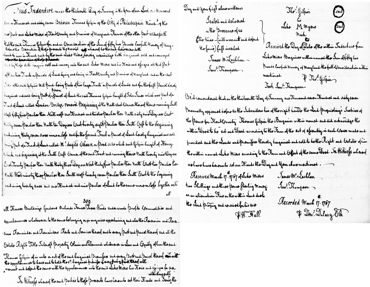
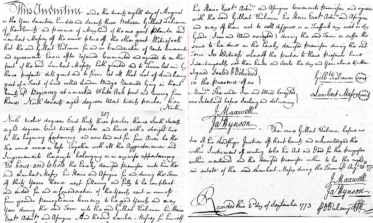
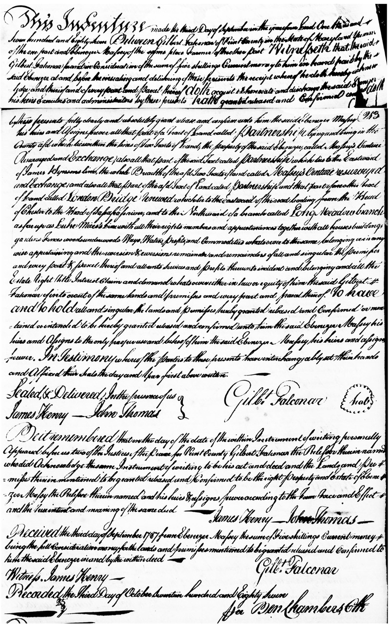
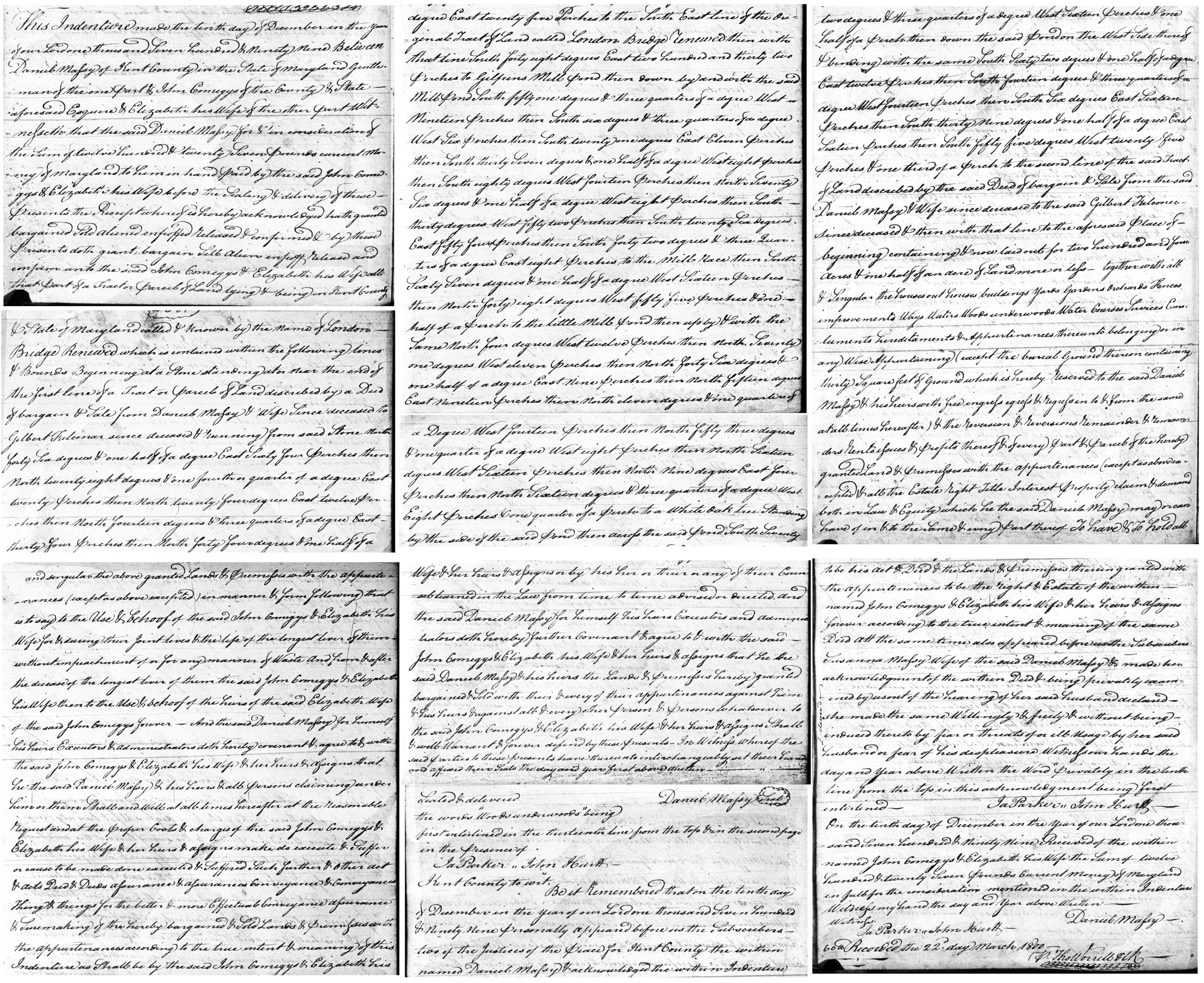
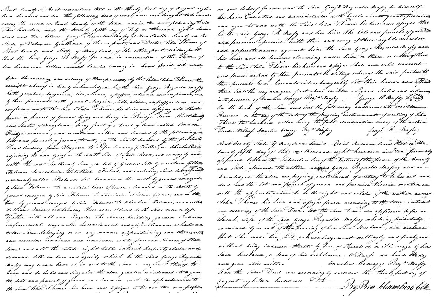
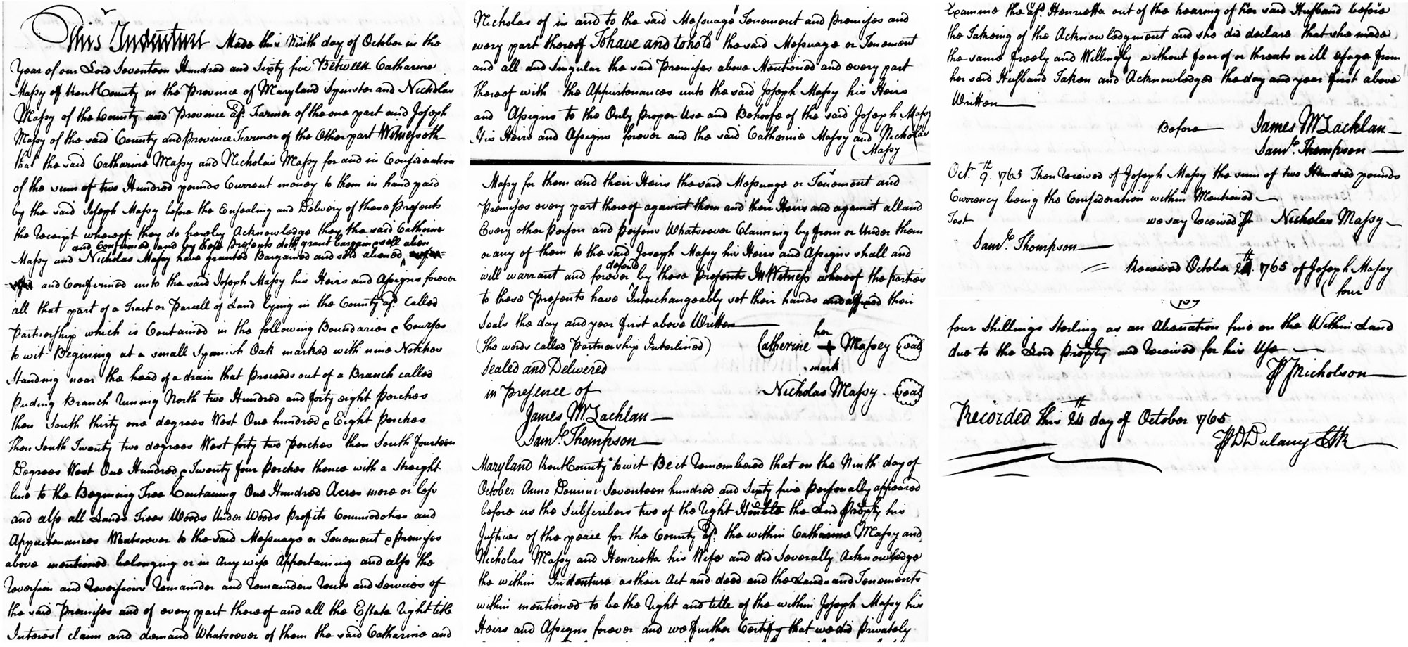
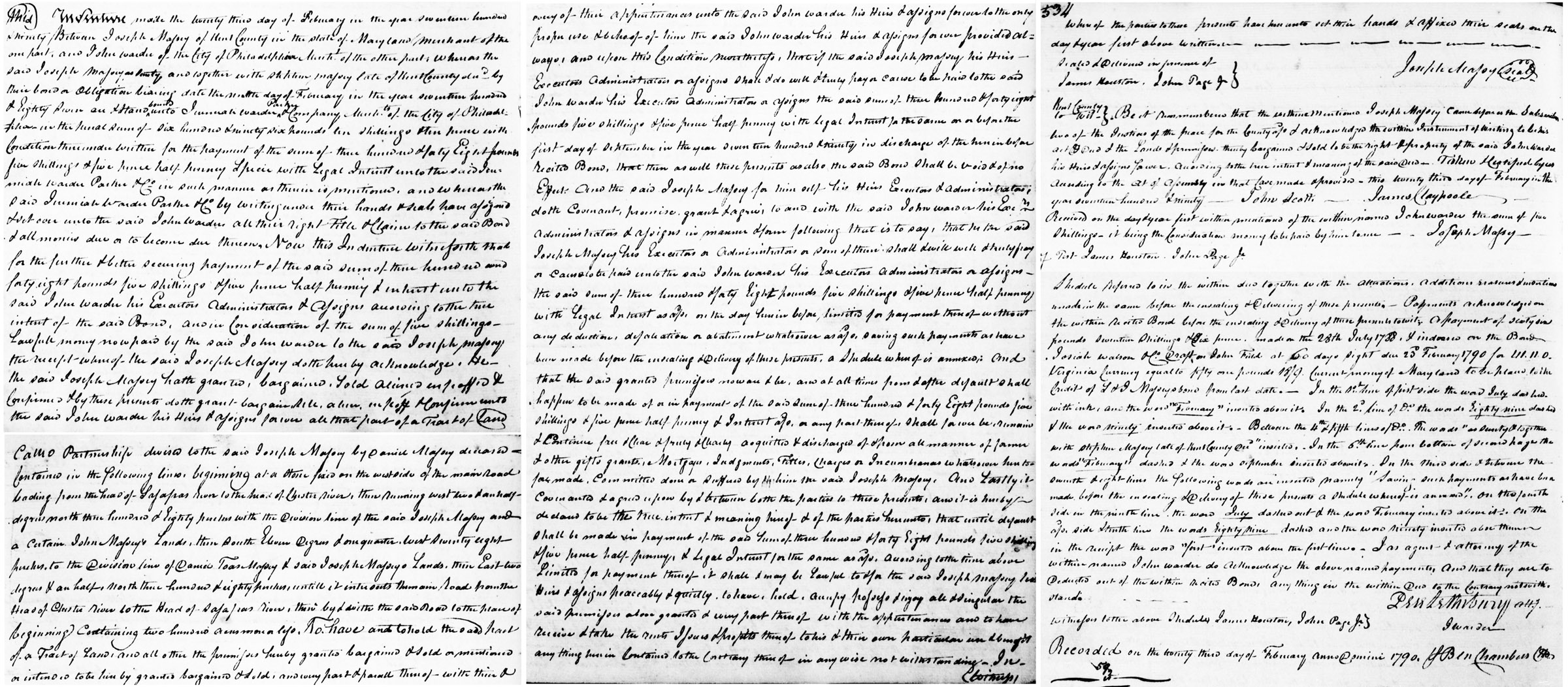
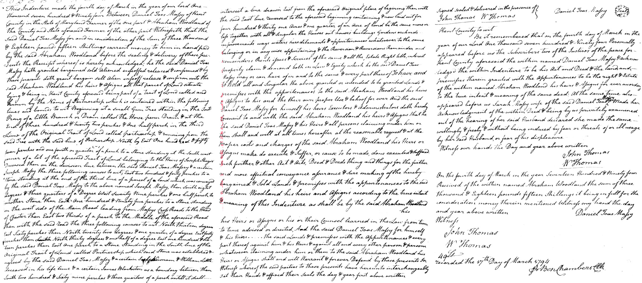
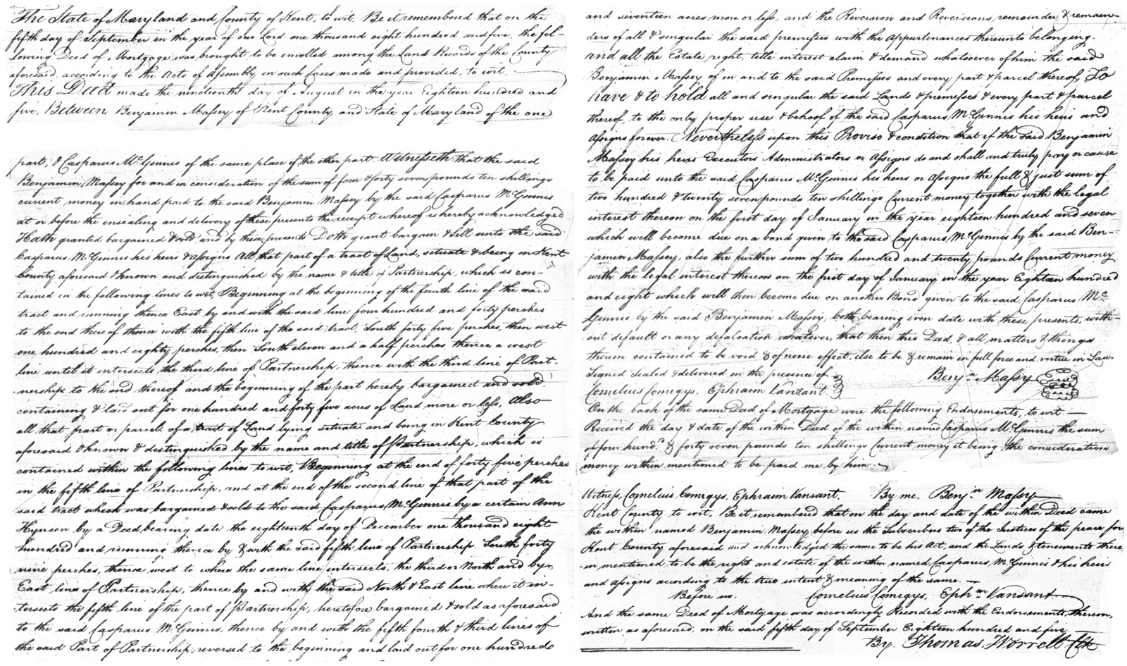
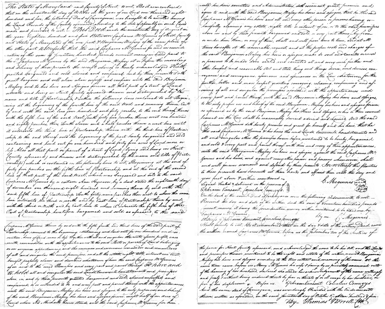
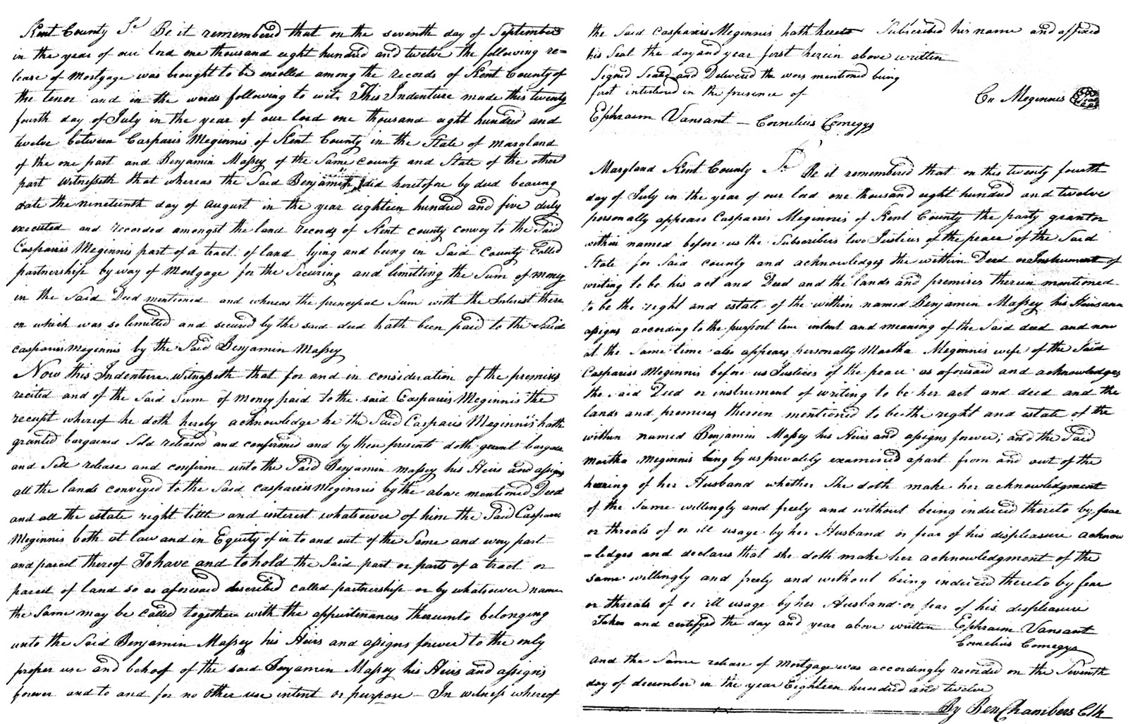
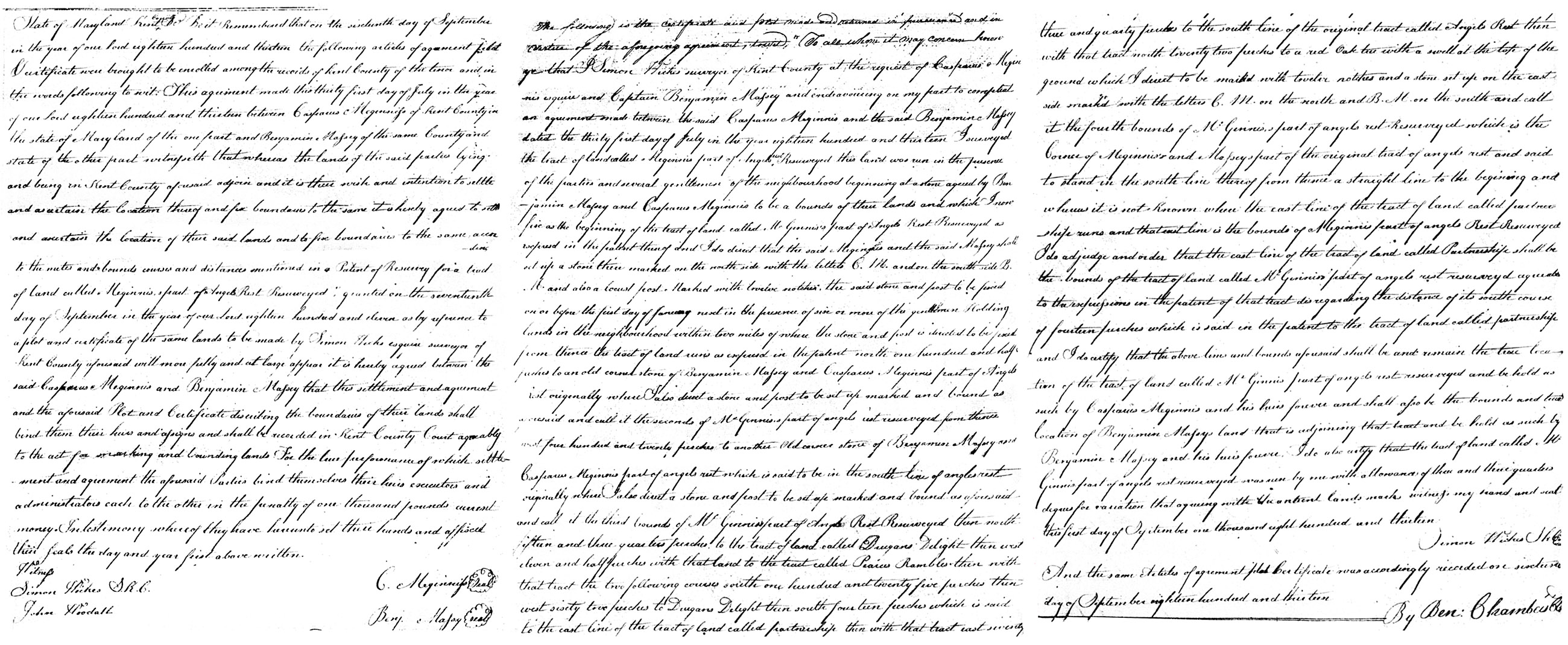
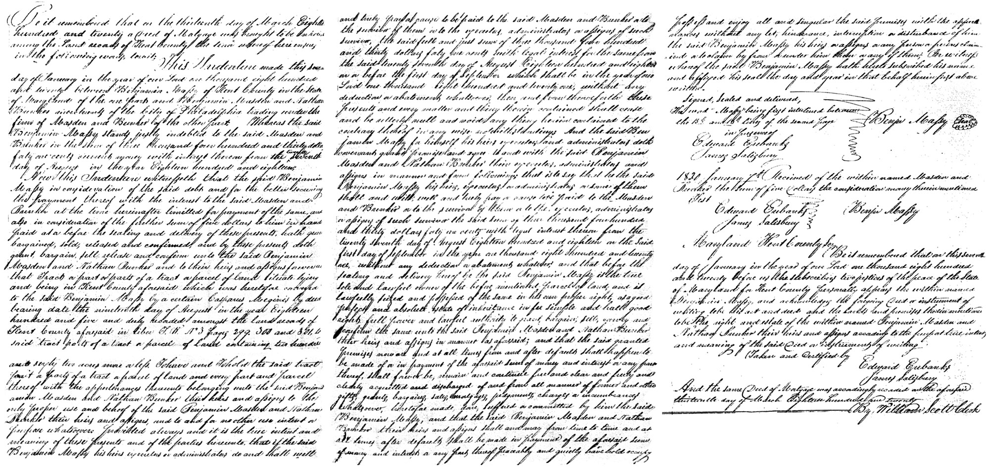
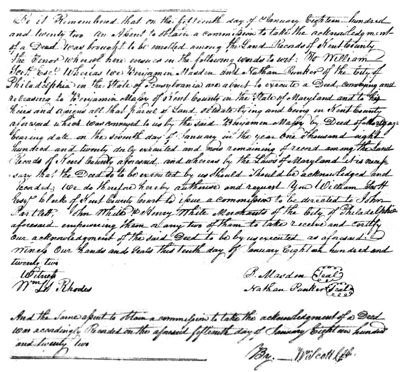
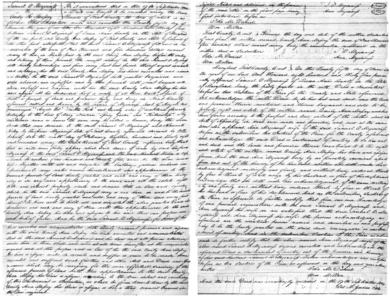
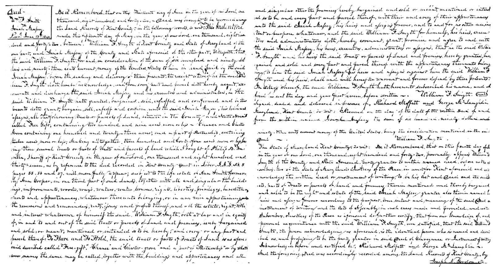
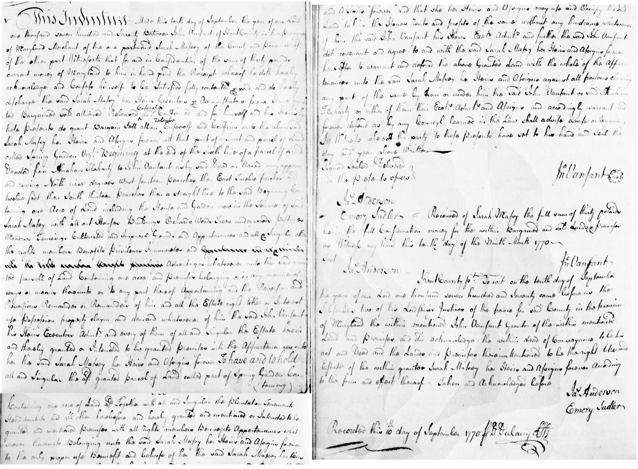
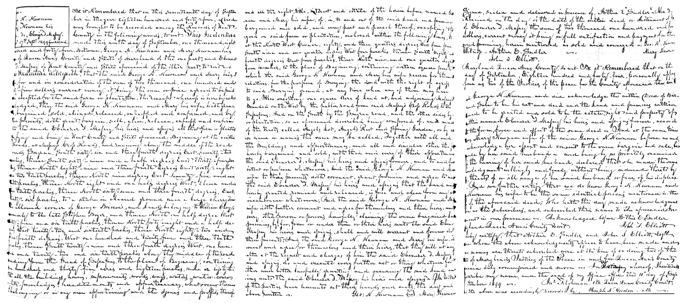