| Section VI - Massey Data Bank | One Maryland Massey Family by George
Langford, Jr. 1901-1996 ©Cullen G. Langford and George Langford, III, 2010 |
Maryland Land Records, Queen Anne's County, BC & GS #14, pp. 375-377
James Massey, patent, March 31, 1761
|
March 31, 1761: James Massey, Sr. of Queen Anne's County in Maryland patents Massey's Part of Friendship Corrected, now totaling 211 acres (the sum of 94 acres in Friendship
(itself totaling 500 acres granted to Col. Richard Tilghman) and
39 acres (bought from Thomas Hynson Wright by James Massey) plus 115
acres in adjacent portions). Survey by Arthur Emery; countersigned for the Crown by Edward Lloyd and H. Sharpe. |
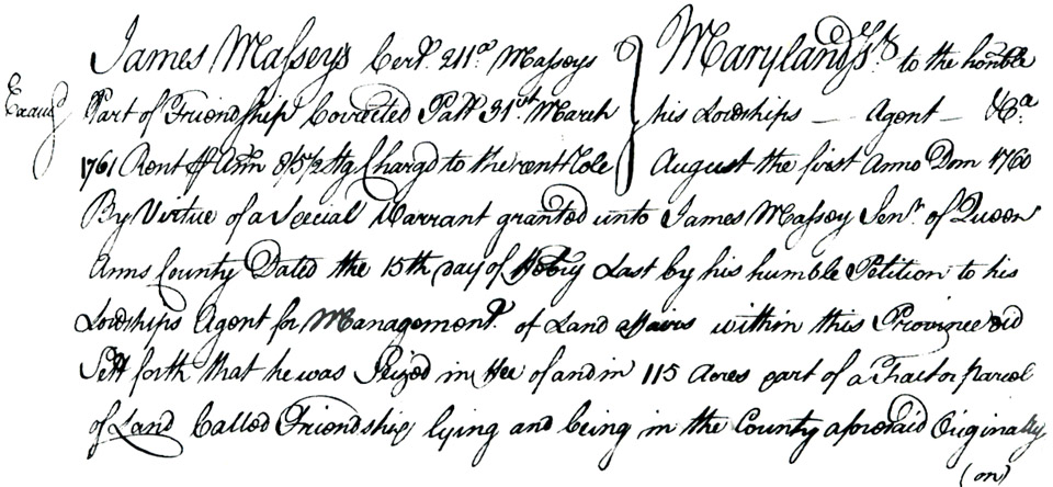
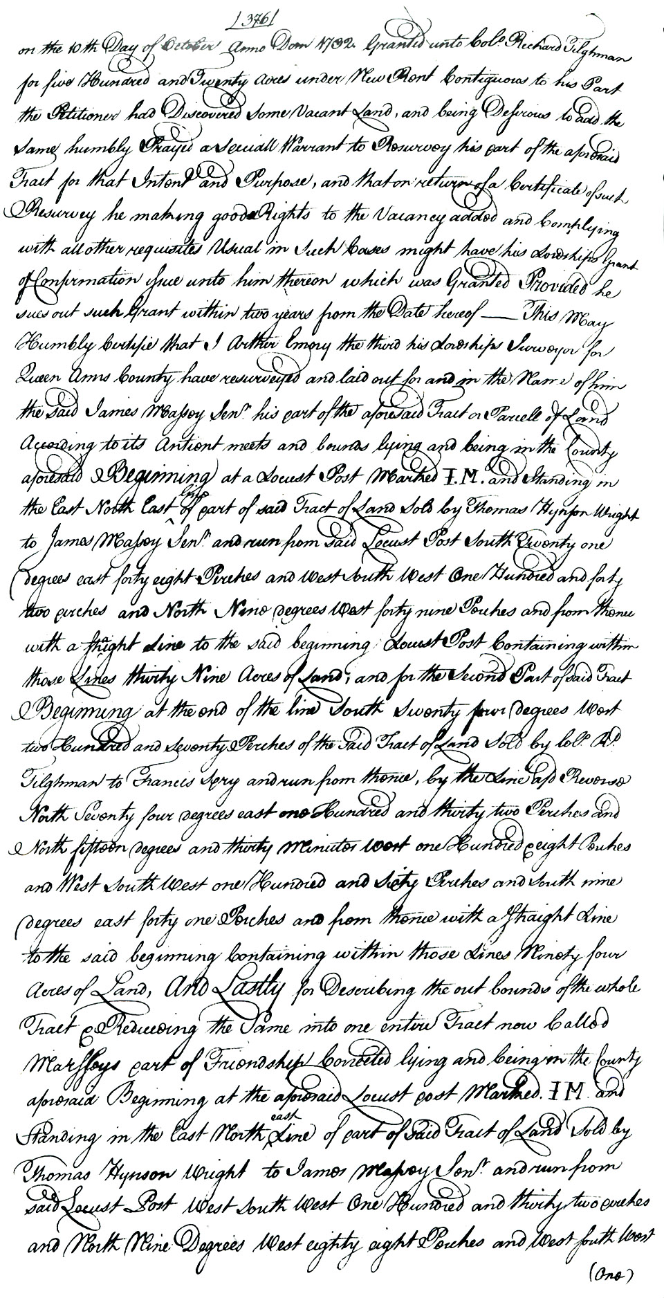
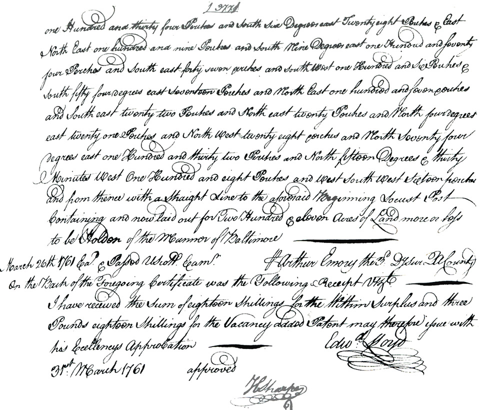
| Examination: James Massey's certificate 211°°: Massey's Part of Friendship Corrected patent 31 March 1761 rent of ann. 8/5/2 sterling charged to the rent role Maryland etc. to the Hon. his Lordship's agent etc. August 1 Anno Domini 1760. By virtue of a special warrant granted unto James Massey Senior of Queen Anne's County dated the 15th day of July last by his humble petition to his Lordship's Agent for Management of Land Affairs within this Province did set forth that he was seized in [illegible] of and in 115 acres part of a tract or parcel of land called Friendship lying and being in the county aforesaid. Originally on the 10th day of October Anno Domini 1762 granted unto Col. Richard Tilghman for five hundred and twenty acres under the New Rent. Contiguous to his part the petitioner has discovered some vacant land, and being desirous to add the same humbly prayed a special warrant to resurvey his part of the aforesaid tract for that intent and purpose, and that on return of a certificate of such resurvey he, making good rights to the vacancy added and complying with all other requisites usual in such cases might have his Lordship's grant of confirmation sure unto him thereon which was granted. Provided he sues out such grant within two years from the date thereof. This may humbly certified that I, Arthur Emory, the Third, his Lordship's Surveyor for Queen Anne's County, have resurveyed and laid out for and in the name of him the said James Massey, Senior, his part of the aforesaid tract or parcel of land according to its antient meets and bounds lying and being in the county aforesaid. Beginning at a locust post marked {IM} and standing in the East North East line of part of said tract of land sold by Thomas Hynson Wright to James Massey Senior and run from said Locust post South twenty one degrees East forty eight perches and West South West one hundred and forty two perches and North nine degrees West forty nine perches and from thence with a straight line to the said beginning locust post, containing within those lines thirty nine acres of land, and for the second part of said tract, beginning at the end of the line South seventy four degrees West two hundred and seventy perches of the said tract of land sold by Col. Richard Tilghman to Francis Fry and run from thence, by the line aforesaid reverse North Seventy four degrees East one hundred and thirty two perches and North fifteen degrees and thirty minutes West one hundred and eight perches and West South West one hundred and sixty perches and South nine degrees and forty one perches and from thence with a straight line to the said beginning containing within those lines ninety four acres of land, And lastly for describing the out bounds of the whole tract and reducing the same into one entire tract now called Massey's part of Friendship Corrected lying and being in the county aforesaid, Beginning at the aforesaid locust post marked {IM} and standing in the East North East line of part of said tract of land sold by Thomas Hynson Wright to James Massey, Senior, and run from said locust post West South West one hundred and thirty two perches and North nine degrees West eighty eight perches and West South West one hundred and thirty four perches and South six degrees East twenty eight perches and East North East one hundred and nine perches and South nine degrees East one hundred and seventy four perches and South East forty seven perches and South West one hundred and six perches South fifty four degrees East seventeen perches and Northeast one hundred and seven perches and South East twenty two perches and North East twenty perches and North four degrees East twenty one perches and North West twenty eight perches in North seventy four degrees East one hundred and thirty two perches and North fifteen degrees and thirty minutes West one hundred and eight perches and West South West sixteen perches and from thence with a straight line to the aforesaid beginning locust post containing and now laid out for two hundred and eleven acres of land more or less to be holden of the Mannor of Baltimore. Arthur Emery, Third, Deputy Surveyor of Queen Anne's County
March 26, 1761 etc.[illegible] Scott exam. On the back of the foregoing certificate was the following receipt viz.: I received the sum of 18 shillings for the within surplus and 3 pounds 18 shillings for the vacancy added. Patent may therefore issue with his Excellency's approbation. Edward Lloyd
31 March 1761.approved
H. Sharpe |
|