| Section VI - Massey Data Bank | One Maryland Massey Family by George
Langford, Jr. 1901-1996 ©Cullen G. Langford and George Langford, III, 2010 |
Maryland Land Records: Surveyors' Certificates & Deeds: Kent County
Note: High-resolution images of the certificates can be viewed at the Maryland State Archives, but registration is required in advance of doing so. Once you have registered,
you can access the images ...
|
| Cert. # |
Images |
Large, complex certificates are listed first: Abstracts; Lesser certificates are here |
||||||
| 85 |
dsl00087-1.jpg dsl00087-2.jpg dsl00087-3.jpg dsl00087-4.jpg dsl00087-5.jpg |
Bridgetown Common
|
||||||
| 133 |
dsl00133-1.jpg dsl00133-2.jpg dsl00133-3.jpg dsl00133-4.jpg |
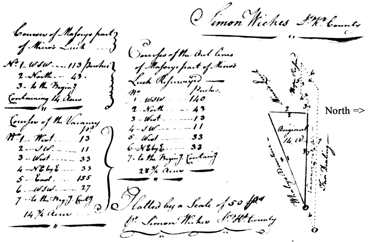
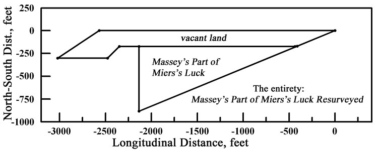
State
of Maryland, Kent County: By virtue of the special warrant to resurvey,
granted to Abednago Massey of said county, dated the 23rd day of April
1783, to resurvey part of a tract of land called Miers's Luck,
originally on the 10th day of August, 1753, granted to Luke Miers, to
correct errors in the original survey and add vacancy if any by the said
warrant may appear. These are therefore to certify that I, Simon Wickes, Surveyor of Kent
County and state aforesaid, have resurveyed for and in the name of
aforesaid Abednago Massey the aforesaid part of a tract of land called Miers's Luck.
Beginning at the end of twenty seven perches West Southwest from a
large stone at the corner of land formerly possessed by Dennis Dulany,
which is said to be the corner of Thomas Massey's land called Whaley's Adventure, and running from thence West South West one hundred and thirteen perches, then North forty three perches to the East line of Miers's Luck,
from thence with a straight line to the beginning, containing fourteen
acres. I have also added one piece of vacancy: Beginning at the end of
the second line of said Massey's Part of Miers's Luck,
and running from thence West thirteen perches, then South West eleven
perches and West thirty three perches, then North East by East thirty
three perches to a tract of land called Fair Dealing,
then with the said tract East one hundred and fifty five perches to the
aforesaid stone at the corner of Dulany's land and West South West
twenty seven perches, from thence with a straight line to the beginning,
containing fourteen and three quarters acres. And lastly I have by
outlines reduced the whole into one entire tract called Massey's Part of Miers's Luck Resurveyed.
Beginning at the aforesaid stone at the corner of Dulany's land and
which is also at the end of or in the line of the tract of land called
Fair Dealing and which was laid out to be the corner of Thomas Massey's
land called Whaley's Adventure, and running from thence West South West one hundred and forty perches, then North forty three perches to the West line of Miers's Luck
and West thirteen perches and South West eleven perches and West thirty
three perches, then North East by East thirty three perches to a tract of
land called Fair Dealing, from
thence with a straight line to the beginning, containing twenty eight
and three quarters acres. There is on the vacancy twenty five hundred
old rails value to three pounds fifteen shillings. Witness my hand this
18th day of December 1783.
|
||||||
| 163 |
dsl00166-1.jpg dsl00166-2.jpg dsl00166-3.jpg dsl00166-4.jpg |
Kent County, Maryland: By virtue of part of a special warrant granted
unto Joshua Vansant of Kent County, bearing date the 17th day of May,
1763, for the quantity of twenty acres of land, lying and being in Kent
County aforesaid, and between the following tracts of land, viz.:
Nicholas Massey's Slipe, Massey's Venture, and Addition to Fair Dealing,
also by virtue of a special warrant granted unto the aforesaid Joshua
Vansant, bearing date the 6th day of September, 1763, for the quantity
of fifty four acres and three quarters of an acre of land lying and
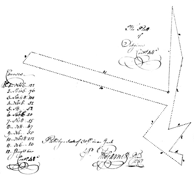
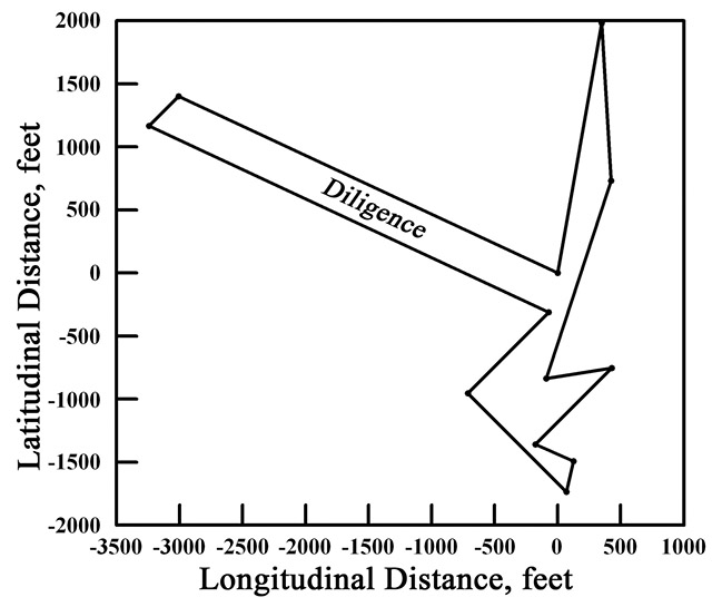
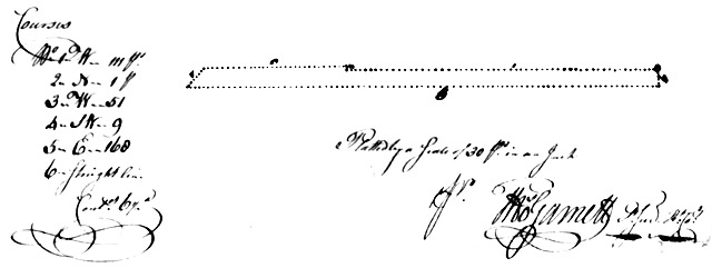
being in Kent County aforesaid and joining to The Slipe Along[side] Massey's Venture, and to the Addition to Fair Dealing, Massey's Venture, and The Exchange, partly cultivated, as by the said warrant may appear, etc.: These are therefore to humbly certify that I, Thomas Garnett, Deputy Surveyor of Kent County (under Benjamin Young, Surveyor General of the Eastern Shore of Maryland) have carefully surveyed and laid out for and in the name of him, the said Joshua Vansant, a parcel of land called Diligence, lying and being in Kent County aforesaid: Beginning at a stone where formerly stood a red oak, the beginning of a tract of land called The Exchange, formerly belonging to Nicholas Massey, deceased, being on the West side of Black Pudding Branch and running thence North ten degrees East one hundred twenty and two perches, then South three degrees thirty minutes East seventy six perches, then South eighteen degrees fifteen minutes West one hundred perches, then North eighty one degrees East thirty two perches, then South West fifty two perches, then South sixty six degrees east twenty perches, then South thirteen degrees West fifteen perches, then North West sixty seven perches, then North East fifty five perches, then North sixty five degrees West two hundred and twelve perches, then North East twenty perches, thence with a straight line to the beginning, containing forty eight acres of land more or less, to be held of his Lordship's Manor of Baltimore in Kent County this 19th day of September Anno Domini 1763. Thomas Garnett, Deputy Surveyor, Kent County
I do also certify that there is about 35 acres of the above land cultivated, partly enclosed with its oak fence whereon is one old leaky brick dwelling house about 20 feet long and 16 feet wide, one story high with a brick chimney, a bastard framed passage between the house and kitchen about 16 feet wide and 16 feet long, one log meat house about 10 feet long and 10 feet wide, one old log house about 14 feet long, 12 feet wide, one old milk house, all covered with featheredge shingles, one brick barn, 10 apple trees ... Test
Thomas Garnett, Deputy Surveyor for Kent County
I have received fifteen pounds for the within improvements, and two shillings for one year's rent of the within land to [illegible] 1764. Patent may therefore issue with his Excellency's approbation. 28 August, 1764. approved,
H. Sharpe Maryland aforesaid: For the consideration of ten shillings currency to me paid, I do hereby transfer and assign all my right and claim of the within certificate to Joseph Massey and Ebenezer Massey or their assigns, as witness my hand and seal this 26th day of April 1764. Joshua Vansant
Signed sealed anddelivered in the presence of Saint Geo. Peale |
||||||
| 349 |
dsl00356-1.jpg dsl00356-2.jpg dsl00356-3.jpg dsl00356-4.jpg dsl00356-5.jpg dsl00356-6.jpg dsl00356-7.jpg dsl00356-8.jpg |
Kent
County Maryland: By virtue the special warrant of resurvey granted
unto Joseph and Ebenezer Massey of Kent County, bearing date the 28th day of
August 1764, to resurvey the following tracts or parcels of land lying and
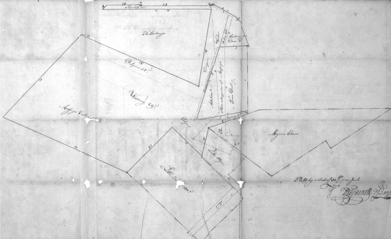
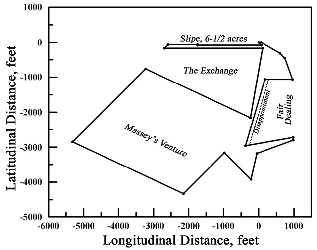
being in the County viz.: Massey's Venture, originally on the sixth day of October, Anno Domini 1719, granted unto Peter and Nicholas Massey for 200 acres. The Slipe Alongside of Massey's Venture, originally on the seventh day of October, Anno Domini 1741, granted unto Nicholas Massey for 25 acres. Pudding Dam, originally on the 19th day of September 1763, granted unto the aforesaid Joseph Massey and Ebenezer Massey for 6 acres. Slipe, originally on the 28th day of August 1764, granted unto the aforesaid Joseph Massey for 6 1/2 acres, and Diligence, originally on the 28th day of August 1764, granted unto the aforesaid Joseph and Ebenezer Massey for 48 acres, all under new rent with liberty therein given to add any vacant land line contiguous thereto and also by two renewments endorsed thereon, the one bearing date the 10th day of December 1764, with liberty to include a tract of land called Disappointment, originally on the 10th day of December 1764, granted under the aforesaid Joseph and Ebenezer Massey for 2 1/4 acres, the other bearing date the fourth day of June 1765 with liberty of including one other tract of land called Delay, lying in the county aforesaid and contiguous to the above-mentioned tracts, originally on the fourth day of June 1765 granted unto the aforesaid Joseph and Ebenezer Massey, 2 acres, under new rent etc. as by the said warrant and endorsements may appear etc. These are therefore humbly to certify that I, Thomas Garnett, Deputy Surveyor of Kent County, under Benjamin Young, Esquire, Surveyor General of the Eastern Shore of Maryland, have carefully resurveyed and laid out for and in the name of them, the said Joseph and Ebenezer Massey, the aforesaid tracts of land according to their [illegible] metes and bounds in manner following, viz.: Massey's Venture: Beginning at the original beginning thereof and running from thence North sixty five degrees West two hundred and twelve perches and North East one hundred and twenty four perches, then South sixty five degrees East one hundred and twelve perches, thence with a straight line to the beginning, containing one hundred and nineteen acres. The Slipe Alongside of Massey's Venture: Beginning at the original beginning thereof and running thence South sixty degrees East thirty eight perches, thence South sixteen degrees West forty eight perches, thence South one hundred and forty perches, then East twenty perches, thence South twenty four degrees West thirty two perches, then South sixty six degrees West sixty two perches, then North East fifty eight perches, then with a straight line to the beginning, containing twenty five acres. Whereas the courses of the aforesaid tract run into extra surveys, I have therefore resurveyed the same and excluded such extra surveys in manner following: Beginning at the original beginning thereof and running thence South sixty six degrees East thirty eight perches, and South sixteen degrees West forty eight perches (which comes to an extra survey called Addition to Fair Dealing) then West eight perches, then South eighteen degrees, fifteen minutes West one hundred and twenty perches, then North eighty degrees East forty six perches, thence South eleven perches (which comes to an extra survey called Myers Chance) thence South seventy one degrees West twenty eight perches, then South thirteen degrees West twenty six perches, then North sixty six degrees West nineteen perches, then North East fifty eight perches, thence with a straight line to the beginning, containing fourteen acres of land clear of extra surveys. Pudding Dam: Beginning at the original beginning thereof and running thence West thirty seven perches, then North sixteen degrees East forty eight perches, then North sixty degrees West thirty eight perches, then East four perches, thence South sixty degrees East thirty eight perches, then South East twelve perches, thence South twenty degrees degrees East thirty nine perches, thence with a straight line to the beginning, containing six acres of land. Slipe: Beginning at the original beginning thereof and running thence West one hundred and eleven perches, then North one perch, then West fifty one perches, thence South West nine perches, then East one hundred and sixty eight perches, thence with a straight line to the beginning, containing six acres and one half an acre of land. Diligence: Beginning at the original beginning thereof and running thence North ten degrees East one hundred and twenty two perches, thence South three degrees thirty minutes East 76 perches, then South eighteen degrees fifteen minutes West one hundred perches, then North eighty one degrees East thirty two perches, then South West fifty two perches, thence South sixty six degrees East twenty perches, thence South thirteen degrees West fifteen perches, then Northwest sixty seven perches, then North East fifty five perches, thence North sixty five degrees West two hundred and twelve perches, then North East twenty perches, thence with a straight line to the beginning, containing forty eight acres of land. Disappointment: Beginning at the original beginning thereof and running thence South eighteen degrees fifteen minutes West one hundred and twenty perches, thence South eighty one degrees West three perches, then North eighteen degrees fifteen minutes East one hundred and twenty perches, thence with a straight line to the beginning, containing two acres and one quarter of an acre of land and is all included in two extra surveys call the Slip Alongside of Massey's Venture and Diligence. Delay: Beginning at the original beginning thereof and running thence North sixteen degrees East forty eight perches and North sixty degrees West seven perches and South sixteen degrees West fifty perches, thence with a straight line to the beginning, containing two acres and is all included in an extra survey called the Slipe Alongside of Massey's Venture. I have also by virtue of the said warrant surveyed and laid out for and in the name of them, the said Joseph and Ebenezer Massey, a piece of vacant land lying contiguous to the aforesaid tract called the Slipe Alongside of Massey's Venture: Beginning at the end of one hundred perches South from the beginning of Addition to Fair Dealing, and running thence South five perches, thence South seventy one degrees West forty perches, then North eleven perches, thence with a straight line to the beginning, containing two acres. I have also surveyed and laid out for and in the name of them, the said Joseph and Ebenezer Massey, one other parcel of vacant land lying contiguous to the tracts called Diligence and Massey's Venture: Beginning at the beginning of Massey's Venture and run running thence North two degrees West one hundred and thirty and one perches, then North sixty five degrees West one hundred and twelve perches, then North East thirty three perches, than South sixty five degrees East two hundred and twelve perches, and South West fifty five perches, than South East sixty seven perches, thence South thirteen degrees West five perches, then North West sixty five perches, thence with a straight line to the beginning, containing fifty nine acres. And lastly I have by virtue of the said warrant reduced the aforesaid seven tracts or parcels of land with the aforesaid two parcels of vacancy into one entire tract now called Massey's Venture Resurveyed: Beginning for the out bounds of the whole lot at a post standing near the end of the East line of a tract of land formerly in the possession of Nicholas Massey, deceased, called The Exchange, it being in the place of the hickory, the original beginning of the Slipe Alongside of Massey's Venture, and running from thence East four perches, thence South sixty degrees East thirty eight perches, then South East twelve perches and South twenty degrees East thirty nine perches and West forty eight perches, thence South eighteen degrees fifteen minutes West one hundred and twenty perches, then North eighty degrees East eighty four perches, thence South five perches, thence South twenty one degrees West sixty seven perches, thence South thirteen degrees West forty six perches and North West sixty five perches and South West one hundred perches, then North sixty five degrees West two hundred and twelve perches, then North East [one hundred and seventy nine] perches, then South sixty five degrees East two hundred perches, then North ten degrees East one hundred and twenty two perches, then West one hundred [and seventy perches] then North East nine perches, then East fifty one perches, then South one perch, then East one hundred and eleven perches, thence with a straight line to the beginning, containing and now resurveyed for two hundred and fifty and four acres and one half an acre of land more or less. To be held of his Lordship's Manor of Baltimore in Kent County this eleventh day of June, Anno Domini 1765. Thomas Garnett, Deputy Surveyor, Kent County
|
| Cert. # |
Images |
Less complex certificates are listed here: Abstracts | Plat; either by PSI-Plot or by the Surveyor |
||||||
| 017 |
dsl00019-1.jpg dsl00019-2.jpg dsl00019-3.jpg dsl00019-4.jpg |
Kent County, Maryland: By virtue of a warrant of resurvey granted unto
George Moffatt of Kent County, bearing date the 7th day of December
1762, to resurvey a tract or parcel of land called The Flower of the Forrest, also The Forrest,
lying and being in Kent County aforesaid, originally on the 10th day of
October Anno Domini 1707 granted unto a certain George Moffatt for the
quantity of 100 acres under new rent, with liberty therein given to add
any vacant land lying contiguous thereto, etc, as by the said warrant
may appear, etc. These are therefore humbly to certify that I, Thomas Garnett, Deputy Surveyor of Kent County, under Benjamin Young, Esq., Surveyor General of the Eastern Shore of Maryland, have carefully resurveyed and laid out for and in the name of him, the said George Moffatt, all the aforesaid tract of land in manner following: Beginning at the original beginning thereof and running thence North West two hundred forty and eight perches, then North East seventy and six perches, then South East one hundred eighty and five perches, thence with a straight line to the beginning, containing and now resurveyed for one hundred and ten acres. I have also by virtue of the said warrant surveyed and laid out for and in the name of him, the said George Moffatt, a parcel of vacant land lying contiguous to the aforesaid Flower of the Forrest: Beginning at a white oak sapling marked with twelve notches standing at the end of forty perches on the first line of The Flower of the Forrest and running thence North and North West two hundred and eight perches, then South West seventeen perches, then North West thirty six perches, then South West ten perches, then South fifty degrees East one hundred forty and eight perches, then East three perches, thence with a straight line to the beginning, containing eighteen acres of land more or less. And lastly I have by virtue of the said warrant reduced the aforesaid tract of land with the aforesaid parcel of vacancy into one entire tract now called Addition to the Flower of the Forrest: Beginning at the original beginning of The Flower of the Forrest and running thence North six degrees East ninety and nine perches, then North West one hundred eighty and five perches, then South West ninety and three perches, then North West thirty and six perches, then South West ten perches, then South fifty three degrees east one hundred and fourteen perches, thence with a straight line to the beginning, containing one hundred and twenty acres of land more or less, to be held of his Lordship's Manor of Baltimore in Kent County this thirty first day of May, Anno Domini 1763. Thomas Garnett, Deputy Surveyor of Kent County
To the Honorable
His Lordship's Agent: I do also certify that there is about 15 acres of the above land cultivated, wherein is about 200 panels of old fence. Test: Thomas Garnett, Deputy Surveyor
I have received nine pence half penny for the within surplus, eighteen shillings for the vacancy
added, and one shilling and one penny half penny for one year and a
half year's rent, thereon to [illegible] 1764. Patents may therefore
issue with his Excellency's approbation.
Edward Lloyd
3 December 1764
Approved
H. Sharpe |
|
||||||
| 73 |
|||||||||
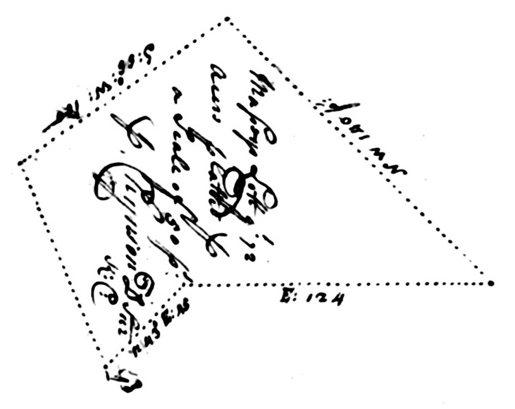
| 138 |
ds100141-1.jpg ds100141-2.jpg ds100141-3.jpg |
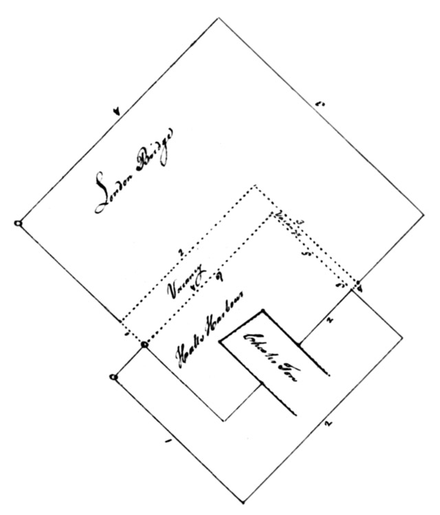
Kent County Maryland: By virtue of a common warrant granted unto Joseph Massey
of Kent County, bearing date the sixth day of May 1760, for the
quantity of four acres and one half acre of land lying and being Kent
County aforesaid. As by the said warrant may appear.these are
therefore humbly to certify that I, Thomas Garnett, Deputy Surveyor of
Kent County under Benjamin Young, Esquire, Surveyor General of the
Eastern Shore of Maryland, have carefully surveyed and laid out for and
in the name of him, the beforesaid Joseph Massey, all the said parcel of
land called The Contest, lying and being in Kent County aforesaid. Beginning at a bounded mulberry post, being the beginning of a tract of land called London Bridge Renewed
and running thence South West by West eight perches and South forty
nine degrees East forty one perches, then with a straight line to the
beginning, containing one acre of land more or less. To be [illegible]
of his Lordship's Manor of Baltimore in Kent County this fourth day of
November Anno Domini 1760. Platted by a scale of 30 ft in an inch. Thomas Garnett, Deputy Surveyor [Note: London Bridge Renewed lies along the Eastern edge of The Contest - GL,III, ed.] |
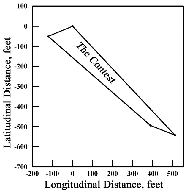 Corners:
Containing 1 acre.
|
||||||
| 154 |
dsl00154-1.jpg dsl00154-2.jpg dsl00154-3.jpg |
Out Range (unpatented) Kent County: Certificate and Plat of the Out Range, 640 acres, for Robert Smith, Esquire.
Q if not already patented
This certificate does not include
... by the Court [illegible] differences & express[es] not a third
part of what it said to contain; Exam by [illegible given name] Spill,
Examiner.
... this mended & patt.
[The plat at right explains what perplexed this examiner - GL,III, ed.]
Maryland, etc.: By virtue of the warrant for two thousand three hundred and thirty five acres of land granted to Robert Smith, Esquire, dated 15 April 1705, I do hereby certify that I have laid out for the said Robert Smith a tract of land called Out Range, lying in Kent County: Beginning at a bounded dogwood tree standing on the north side of the main branch of Chester River and near by a branch and running thence North East and by North three hundred and twenty perches, then North West by West three hundred and twenty perches, then South East by South three hundred and twenty perches, and then to the first tree, containing and now laid out for six hundred and forty acres more or less to beholden of the Manor of Baltimore the 15th day of May 1705. By Mr. Solomon Wright, Deputy Surveyor of Kent County
|
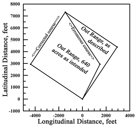 PSI-Plotted plat of Certificate No.154, both as described and as intended. |
||||||
| 159 |
dsl00162-1.jpg dsl00162-2.jpg dsl00162-3.jpg |
Kent County, Maryland: By virtue of a special warrant granted unto
Joshua Vansant of Kent County, bearing date the 6th day of September,
1763 for the quantity of fifty four acres and three quarters of an acre
of vacant land lying and being in the county aforesaid and joining to
the Slipe Along[side] Massey's Venture, and to the Addition to Fair Dealing, Massey's Venture, and The Exchange,
etc. and by the renewment endorsed thereon, bearing date the 10th day
of December, 1764, for the quantity of twelve acres, being the remainder
of the aforesaid warrant not yet [illegible] by the said warrant and
endorsement may appear... These are therefor humbly to certify that I, Thomas Garnett, Deputy Surveyor of Kent County (under Benjamin Young, Esq., Surveyor General of the Eastern Shore of Maryland) have carefully surveyed and laid out for and in the name of him, the said Joshua Vansant, all that tract or parcel of land called Delay, lying and being in Kent County aforesaid: Beginning at the end of thirty seven perches West from the beginning of Addition to Fair Dealing and running thence North sixteen degrees East forty eight perches, then North sixty degrees West seven perches, then South sixteen degrees West fifty perches, thence with a straight line to the beginning, containing two acres of land more or less, to be held of his Lordship's Manor of Baltimore in Kent County this third day of June, 1765. Thomas Garnett, Deputy Surveyor, Kent County
For a valuable consideration to me in hand paid by Joseph Massey and Ebenezer Massey of Kent County, I do hereby assign over all my right, title, and interest of the within certificate unto them, the said Joseph and Ebenezer Massey, their heirs and assigns. As witness my hand this fourth day of June, Anno Domini 1765. Joshua Vansant
Witness:
Saint Geo. Peale |
|
||||||
| 164 |
ds100167-1.jpg ds100167-2.jpg ds100167-3.jpg |
Kent
County Maryland. By virtue of part of a special warrant granted unto
Joshua Vansant of Kent County, bearing date the sixth day of September
1763, for the quantity of fifty four acres of land by the warrant
[illegible] thereon bearing date the twenty-eighth day of August 1764.
As by the said warrant may appear etc. These are therefore humbly
to certify that I, Thomas Garnett, Deputy Surveyor of Kent County under
Benjamin Young, Esquire, Surveyor General of the Eastern Shore of
Maryland, have carefully surveyed and laid out for and in the name of
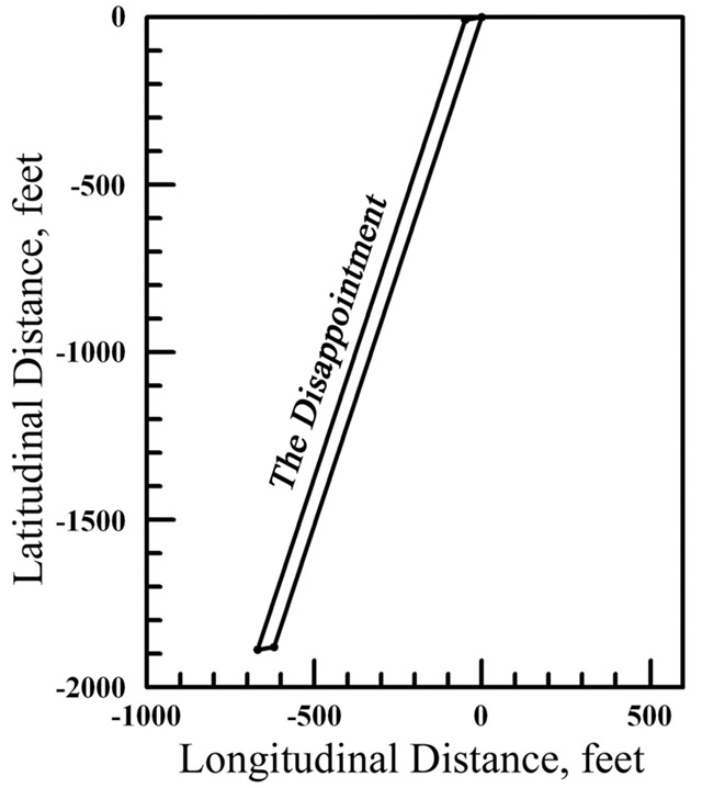
him, the said Joshua Vansant, all that parcel of land called The Disappointment, lying and being in Kent County aforesaid. Beginning at the end of forty six perches on the West line of the Addition to Fair Dealing
and running thence South eighteen degrees, fifteen minutes West one
hundred and twenty perches and South eighty one degrees West three
perches, then North eighteen degrees, fifteen minutes East one hundred
and twenty perches, and thence with a straight line to the beginning,
containing two and one quarter acres of land, more or less, to be held
of his Lordship's Manor of Baltimore in Kent County this eighth day of
November Anno Domini 1764. Thomas Garnett, Deputy Surveyor, Kent County
Courses:
|
Contains 2-1/4 acres.
Platted by a scale of 30 ft. in an inch.
See:068.Joseph Massey Y-75.Ebenezer Massey |
||||||
| 184 |
dsl00188-1.jpg dsl00188-2.jpg dsl00188-3.jpg dsl00188-4.jpg |
Kent
County. By virtue of a warrant for two hundred acres of land
granted unto William Comegys and aforesaid county, bearing date the
twelfth day of April last past, and 100 acres thereof signed unto
Richard Massey of Queen Anne's County as may appear viz.: These are therefore to certify that I, James Harris, Deputy Surveyor of aforesaid county, have laid out for and in the name of the said Richard Massey of Queen Anne's County all that tract or parcel of land called The Exchange lying and being in the county aforesaid and on the North 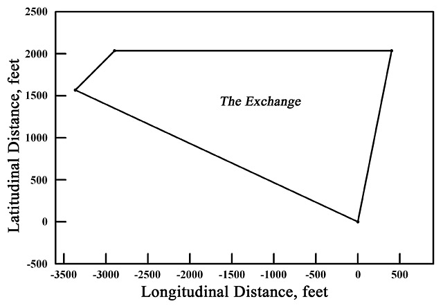 side of the
head of Chester River. Beginning at a bounded red oak standing on the
West side of a branch called Black Pudding Branch near the mouth thereof, and on
the North side of an old path that leaves from one Gilbert Falconer's to
the Cypress Swamp, and running from the said red oak North sixty five
degrees West two hundred and twenty five perches, thence North East forty side of the
head of Chester River. Beginning at a bounded red oak standing on the
West side of a branch called Black Pudding Branch near the mouth thereof, and on
the North side of an old path that leaves from one Gilbert Falconer's to
the Cypress Swamp, and running from the said red oak North sixty five
degrees West two hundred and twenty five perches, thence North East forty
(continuing at top right ===>)
|
perches, then East two hundred perches, thence with a straight line to the first bounded tree aforesaid,
now laid out for one hundred acres of land more or less to be holden
the Manor of Baltimore as willing. My hand this sixteenth day of May
Anno Domini seventeen hundred and eighteen. James Harris, Deputy Surveyor,
Kent County
|
||||||
| 192 |
dsl00192-1.jpg dsl00192-2.jpg dsl00192-3.jpg dsl00192-4.jpg |
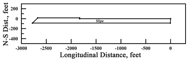
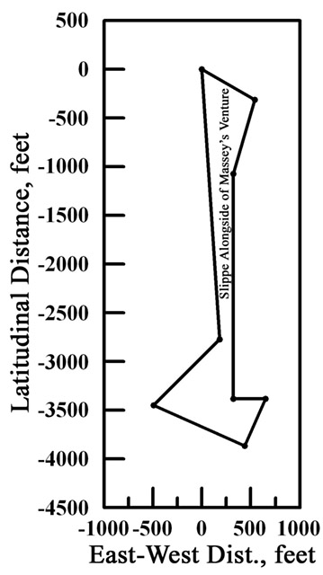
The Slippe Alongside of Massey's Venture
Kent
County: By virtue of part of a special warrant granted Peter Massey and
Nicholas Massey of Kent County on 19th March last for fifty five acres
of land is made appear etc. This is to certify that I, the subscriber,
Deputy Surveyor of Kent County, surveyed and laid out for the aforesaid
Peter and Nicholas Massey a parcel of land called The Slippe Alongside of Massey's Venture
lying contiguous and adjoining the aforesaid Nicholas Massey land in
the aforesaid county. Beginning at a bounded hickory standing at the end
of the East line of aforesaid land lying in Kent County [three
illegible words] that issues out of Chester River and running from said
hickory South 60° East 38 perches and South 16° West 48 perches
and South 140 perches, thence East 20 perches, thence South 24° West
32 perches, thence North 66° [West] 62 perches, thence North East
68 perches, thence by a straight line to the beginning hickory,
containing and now laid out for twenty five acres of land more or less,
whereon is contained about three acres of cleared ground in a long
narrow slip with an indifferent oak rail fence along one side or better
of the same ground, one post in the ground clapboarded thirty foot long
indifferent old dwelling house, one ten foot long boarded house, and one
small log corn house etc. The said land to be held of the Manor of
Baltimore in Kent County, 30 March 1730. Platted by a scale of 100 feet
in an inch.George Skirven, Deputy Surveyor Kent County
|
|
||||||
| 197 |
dsl00201.jpg dsl00202.jpg dsl00203.jpg dsl00204.jpg dsl00205.jpg |
Forrest Kent County in Maryland: By virtue of
a warrant granted Charles Hynson the eighteenth day of May last for
three hundred acres of land by him assigned to Gideon Pierce of the
aforesaid county and also a warrant granted to the same Gideon Pierce
the thirteenth day of October last for five hundred acres of land and
also another warrant granted the same Gideon Pierce the twenty firstst
day of October last for one hundred acres of land more, which said three
warrants amounts in the whole to the quantity of nine hundred acres.
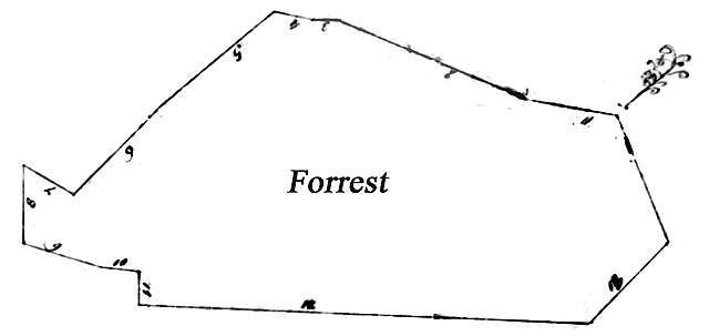
These are therefore to certify that I, James Smith, Deputy Surveyor of Kent County under Michael Howard, Esquire, Surveyor General of the Eastern Shore, hath laid out for and in the name of him, the said Gideon Pierce, all that tract or parcel of land called the Forrest. Beginning at a Spanish oak standing on the West side of a branch called the Doogg Branch or Toas Mill Branch and on the lower side of the branch called the Bare Branch and near the mouth of the same which runs out of the aforesaid Doogg or Mill Branch on the North side of Chester River in Kent County and running from the said Spanish oak North eighty degrees West ninety five perches, thence West North West two hundred and four perches, then West twenty eight perches, then West and by North forty perches, thence South fifty degrees West one hundred and fifty three perches, then South West one hundred and twenty four perches, then North sixty degrees West sixty perches, then South eighty two perches, thence South eighty four degrees East forty perches, thence South thirty six perches, thence South eighty seven degrees East four hundred and sixty perches, then North East one hundred and fifteen perches, and from thence to the first beginning tree, containing and laid out for nine hundred acres of land, more or less, to be held of the Manor of Baltimore, this ninth day of November Anno Domini 1727. James Smith, Deputy Surveyor Kent County
On the back of the certificate is thus endorsed: Kent County aforesaid: I do assigned to Gideon Pearce of this county all my right, title, and interest of the within warrant, as witness my hand this 19th day of May Anno Domini 1727. Charles Hynson
|
|
||||||
| 208 |
dsl00212-1.jpg dsl00212-2.jpg dsl00212-3.jpg dsl00212-4.jpg |
Know
all men by these presents that I, George Dunkan of Kent County, have
and do hereby assign, transfer, and make over onto Zorobabel French of
Kent County, planter, twenty two acres, part of a common warrant granted
to me by a new warrant for one hundred twenty five acres on the 16th
day of April last. To have and to hold the said twenty two acres as part
of these and warrant under him, the said Zorobabel French, his heirs,
and assigns, forever to his and their own proper use. As witness my hand
and seal this 29 day of August Anno Domini 1746. George Dunkan {Seal}
Kent County Maryland: By virtue of a
common warrant granted to George Dunkan of Kent County for three hundred
acres of land, bearing date on the 22nd day of April, Anno Domini 1745,
and 175 acres, part thereof being renewed by a resurvey thereon bearing
date on the 16 day of April last, and by virtue of an assignment from
the said George [Dunkan] of twenty two acres, part of the 175 acres, to
Zorobabel French of Kent County aforesaid, bearing date on the 29th day
of this instant August as by the aforesaid warrant and the assignment of
hereto annexed may appear viz.:
These are humbly to certify that I,
George Garnett, Deputy Surveyor of Kent County under the Hon. Benjamin
Young, Esquire, Surveyor General of the Eastern Shore of Maryland: I
have surveyed and laid out for and in the name of him the said Zorobabel
French all that tract of land called French's Lott, lying in Kent County aforesaid. Beginning at a bounded white oak being the beginning tree of a tract of land called Burks
and running from thence North East sixty four perches, thence South
eighty two perches and South West sixty four perches, thence with a
straight line to the beginning white oak, containing and now laid out
for twenty two acres of land, more or less, to behold of his Lordship's
Manor of Baltimore in Kent County this 29 day August, Anno Domini 1748.
George Garnett, Deputy Surveyor of Kent County.
|
Platted by a scale of 50 perches in an inch. |
||||||
| 256 |
dsl00262-1.jpg dsl00262-2.jpg dsl00262-3.jpg dsl00262-4.jpg dsl00262-5.jpg |
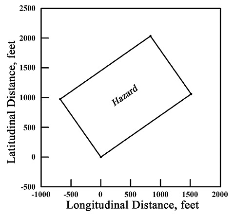
Hazard Kent County in Maryland: by virtue of
a warrant of fifty acres of land granted to the Zorobabel French of the
said county bearing date at Annapolis the thirteenth day of July last
past has by the same warrant may appear:
These are therefore to certify that I, Charles Hynson, Deputy Surveyor of Kent County, hath laid out for and in the name of the Zorobabel French all that tract or parcel of land called Hazard, lying and being in the said county near the head of Chester River. Beginning at a bounded Spanish oak, standing on the West side of the branch called the Dead Branch about 100 feet above the old Duck Creek path, and running North 55° East 112 perches, then North 35° West 72 perches, thence South 55° West 112 perches, thence in a straight line to the beginning tree, containing and now laid out for 50 acres more or less, to be held of the Manor of Baltimore this 20th day of October Anno [Domini] 1725. Charles Hynson, Deputy Surveyor Kent County
Maryland aforesaid: To the Hon.
Benjamin Young and George Stewart, Esquire, the Lord Proprietary's Chief
Judges in land affairs within this province:
The petition of Samuel French of Kent County humbly show us that a certain Zorobabel French, your petitioner's father, had on the 20th day of October anno Domini 1725 surveyed and laid out for him a certain tract or parcel of land called Hazard, lying and being in the county aforesaid, containing 50 acres by virtue of a warrant for that quantity granted him in common form the 13th day of July in the year aforesaid, which said warrant expressly mentions the caution money to have been paid at the time of granting the same; but before he, the said Zorobabel French [illegible] put his Lordship's grant for the same, he died; and by his last will and testament in writing, duly made and recorded, among the things devised the aforesaid tract called Hazard onto your petitioner, Samuel French, who therefore humbly prays that, for as much as he has paid and satisfied onto Benjamin Tasker, Esquire, his Lordship's present Agent and Receiver General for his use all the [illegible] rents which were due from the time of making the said survey, his Lordship's grant may issue to him thereon. And as in duty bound he'll pray
To the clerk of the land office, ninth of April 1752. |
|
||||||
| 265 |
dsl00272-1.jpg dsl00272-2.jpg dsl00272-3.jpg dsl00272-4.jpg dsl00272-5.jpg |
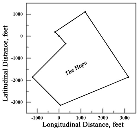
The Hope Know all men by these presents that
I, William Comegys, out of a warrant for four hundred acres of land did
and by these presents do sign unto Gilbert Falconar, his heirs and
assigns, the two hundred and ten acres of land laid out as by this where
it appears the said Gilbert paid [illegible] money for said assignment
before this return was made and I accordingly wrote an assignment on the
original warrant as is usual and I give this but as a further
confirmation of that and that [illegible] may be lodged in the land
office. Witness my hand and seal this tenth day of April Anno Domini
1724.
William Comegys
Witness:
John Blundl Cornelius Comegys Kent County: By virtue of a warrant of two hundred and ten acres of land from William Comegys to Gilbert Falconar, being part of a warrant of four hundred acres of land granted to the aforesaid Comegys on the twenty sixth day of March last past as may appear: These are therefore to certify that I, James Harris, Deputy Surveyor of Kent County, have laid out and surveyed for and in the name of the aforesaid Gilbert Falconar all that tract or parcel of land called The Hope lying and being in Kent County aforesaid on the North side of Chester River: Beginning at a bounded 10"oak standing on the South side of a great branch at the head of the said river called the Cypress Branch and near against the aforesaid mouth of a branch running out of the said Cypress branch called the Black Pudding Branch and running from the aforesaid oak North West sixteen perches, then North East by East one hundred perches, thence South East by South two hundred and sixteen perches, thence West South West two hundred and three perches, thence North West one hundred and ten perches, thence North East one hundred and thirty perches, and thence with a straight line to the aforesaid first bounded tree, [laid out for] two hundred and ten acres of land, more or less, to be holden of the Manor of Baltimore aforesaid [illegible] this 10th day of April 1719. James Harris, Deputy Surveyor, Kent County
|
|
||||||
| 327 |
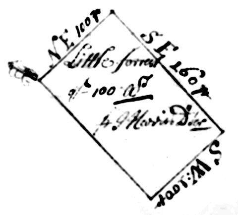
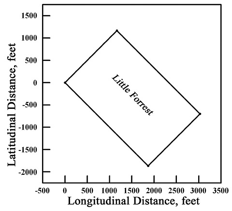
dsl00333-1.jpg dsl00333-2.jpg dsl00333-3.jpg |
Kent County: By virtue of a warrant for two hundred acres of land
granted unto Mr. William Comegys of said county, bearing date the
twelfth day of April last, part of may appear etc.: These are therefore to certify that I, James Harris, Deputy Surveyor of Kent County, have laid out and surveyed for and in the name of said William Comegys all that tract or parcel of land called Little Forrest, lying and being in the county aforesaid and on the North side of Chester River and on the North side of a great branch proceeding out of the head of said river called the Cypress Branch: Beginning at a bounded white oak being the Easternmost bounded tree of a parcel of land called Well Meaning, and running from said oak North East one hundred perches, then South East one hundred and sixty perches, thence South West one hundred perches, from thence North West unto the first bounded tree, containing and now laid out for one hundred acres of land, more or less, to be holden of the manor of Baltimore as witness my hand this twenty seventh day of August, Anno [Domini] 1718. James Harris, Deputy Surveyor, Kent County
|
Well Meaning lies directly West of Little Forrest and shares its Eastern corner with the Western corner of Little Forrest.
|
||||||
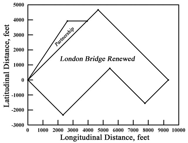
| 329 |
dsl00335-1.jpg dsl00335-2.jpg dsl00335-3.jpg dsl00335-4.jpg dsl00335-5.jpg |
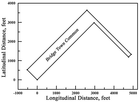
Kent
County Maryland: By virtue of the special warrant of resurvey granted
to Daniel Massey of Kent County, bearing date 29 day of August 1752, to
resurvey sixty acres of land, being part of a tract of land called Partnership,
lying in Kent County, originally on the 17th day of February 1684
granted unto a certain Daniel Toes 3,000 acres under new rent with
liberty and the said warrant to act any vacant land lying contiguous and
to reduce the same into one entire tract is by the said warrant may
appear viz.: These are therefore humbly to certify that I, George Garnett, Deputy Surveyor, Kent County under the Hon. Benjamin Tasker, Junior, Esquire, Surveyor General of the Eastern Shore of Maryland, have carefully resurveyed and laid out for and in the name of him, the said Daniel Massey, a parcel of land, part of the aforesaid tract called Partnership. Beginning at a bounded mulberry post, standing in the place of the original beginning tree of Partnership, and running thence North East by North two hundred eighty six perches, from thence East eighty six [80 perches fits better- GL,III, ed.] perches, thence with a straight line to the beginning mulberry post, containing and now resurveyed for sixty acres of land more or less. Also I have, by virtue of the aforesaid warrant, surveyed and laid out for and in the name of him, the said Daniel Massey, a parcel of vacant land lying contiguous to the aforesaid part of Partnership. Beginning at the bounded mulberry post standing in place of the original beginning of Partnership and running thence North East four hundred perches and South four hundred perches, then Southwest one hundred thirty three perches and one third of a perch, then North West two hundred perches, then South West two hundred sixty six perches and two thirds of a perch, thence with a straight line to the beginning mulberry post, containing six hundred and fifty acres of land, more or less. And lastly I have by virtue of the said warrant reduced the aforesaid part of Partnership so as aforesaid resurveyed, together with the said vacancy, added into one entire survey now called London Bridge Renewed. Beginning for the outer bounds thereof at a bounded mulberry post standing in the place of the original beginning of Partnership and running thence North East by North two hundred and eighty and six perches, then East eighty perches and North East sixty perches, thence South East four hundred perches and Southwest one hundred thirty three perches and one third of a perch, then North West two hundred perches, thence Southwest two hundred sixty six perches and two thirds of a perch, thence with a straight line to the beginning, containing and now resurveyed for seven hundred and ten acres of land more or less. To be hold of his Lordship's Manor of Baltimore, Kent County the 16 day of January 1753. George Garnett, Deputy Surveyor of Kent County
I do humbly certify that there is
contained on the vacant land added on this survey about one hundred
acres of cultivated ground, twelve scattering apple trees, one old 40
foot tobacco house, two old small log houses.
George Garnett, Deputy Surveyor of Kent County
I have received the sum of thirty
pounds ten shillings sterling for the within vacancy and two pounds ten
shillings for the improvements; patents may therefore issue with his
Excellency's approbation.
[illegible signature]
8 August 1754
Platted by a scale of 100 perches in an inch.===>
|
Courses:
|
||||||
| 347 |
dsl00354-1.jpg dsl00354-2.jpg dsl00354-3.jpg |
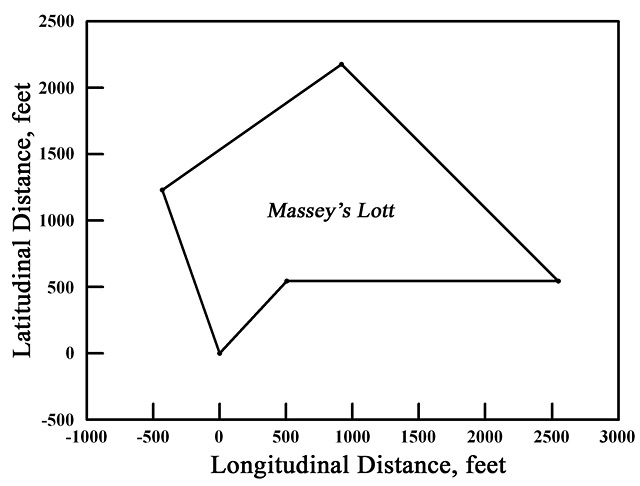
Kent
County, Maryland: By virtue of the warrant for two hundred acres of
land granted to William Massey of Queen Anne's County, bearing date at
Annapolis the 28th day of February last past as may appear, etc.: These
are therefore to certify that I, Charles Hynson, Deputy [Surveyor] of
the said county, has laid out for and in the name of the said William
Massey all that tract or parcel of land called Massey's Lott,
lying and being in the said county on the North side of the Chester
River. Beginning at a bounded red oak standing on the North side of a
branch called Pudding Branch, respecting a parcel of land laid out for
William Burt, and continuing from said red oak North forty three degrees
East forty five perches, then East one hundred and twenty four perches,
then North West one hundred and forty perches, thence South fifty five
degrees West one hundred perches, thence by a straight line to the
beginning tree, containing and now laid out for seventy two acres, more
or less, to be held of the Manor of Baltimore this 29th day of March,
Anno Domini 1722. Charles Hynson, Deputy Surveyor, Kent County
|
Courses:
|
||||||
| 348 |
dsl00355-1.jpg dsl00355-2.jpg dsl00355-3.jpg |
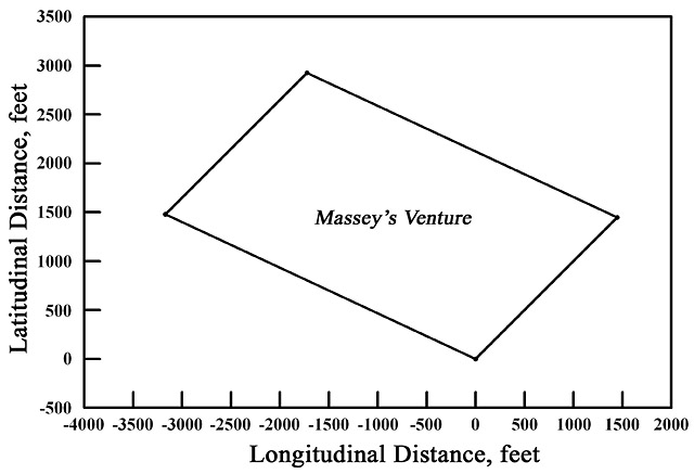
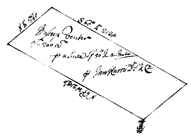
Maryland:
By virtue of a warrant for two hundred acres of land granted unto Peter
Massey and Nicholas Massey bearing date the 16th day of September last
past as may appear: These are therefore to certify that I, James Harris, Deputy Surveyor of Kent County, have laid out and surveyed for and in the name of the aforesaid Peter Massey and Nicholas Massey all that tract or parcel of land called Massey's Venture, lying and being in Kent County and on the North side of Chester River and on the North West side of a branch called the Cypress Branch, beginning at a bounded red oak standing near the aforesaid branch and on the West side of a small branch running out of said Cypress Branch, it being the uppermost bounded tree of a parcel of land called Well Meaning, and running from the said oak North sixty five degrees West two hundred and twelve perches, then North East one hundred and twenty four perches, thence South sixty five degrees East two hundred and twelve perches, and then along a straight line to the first bounded tree, containing and now laid out for two hundred acres of land more or less, to be held of the Manor of Baltimore and witness my hand this seventh day of March Anno [Domini] one thousand seven hundred and seventeen. James Harris, Deputy Surveyor Kent County
|
|
||||||
| 355 |
dsl00362-1.jpg dsl00362-2.jpg dsl00362-3.jpg dsl00362-4.jpg dsl00362-5.jpg |
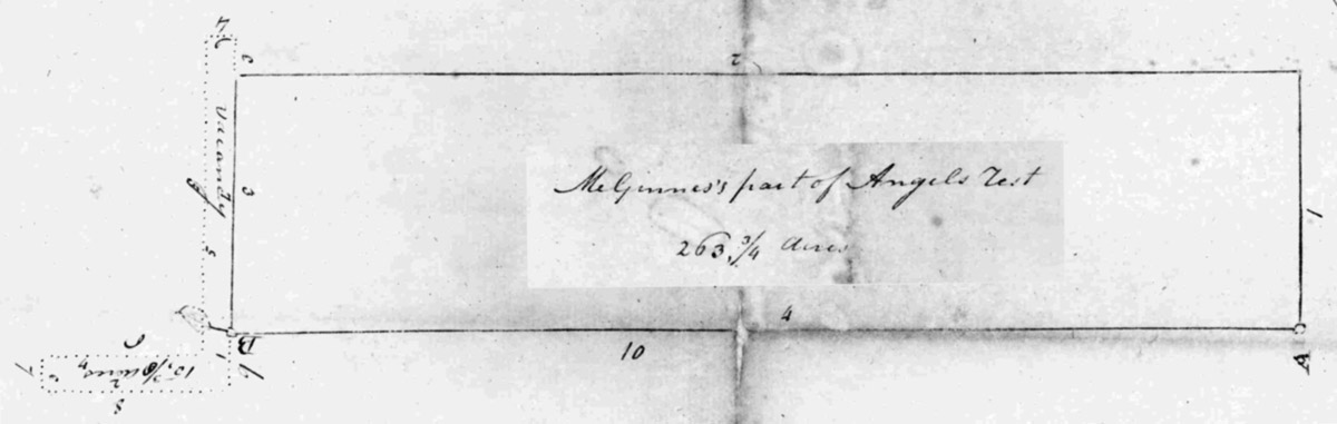
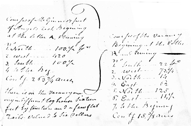
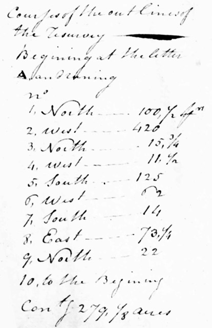
McGinnes Part Of Angels Rest Resurveyed Kent County in
Maryland: By virtue of a warrant of resurvey granted Casparis MeGinnes
of the county and state aforesaid, bearing date the third day of January
eighteen hundred and three to resurvey his part of a tract of land
called Angels Rest originally on the tenth day of Sept. 1684 granted to
Bryan Omealy for 1200 acres and add vacancy if any as by the said
warranty may appear.
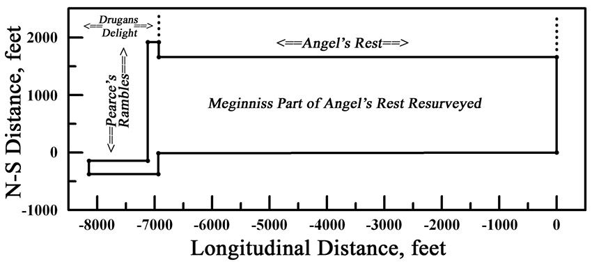
These are therefore to certify that I, Simon Wickes, Surveyor of Kent County and State aforesaid by virtue of the said warrant have resurveyed and laid out for and in the name of the said Casparis MeGinnes the part of the said tract which he the said Casparis MeGinnes claims and which is clear of older surveys. Beginning at a stone standing in a division line between Benjamin Massey and the aforesaid Casparis MeGinnes and at the end of the first line of that part of Angels Rest which formerly belonged to Richard Gibson and running from said stone as the table of the courses of MeGinnes's part of Angels Rest hereto annexed containing two hundred and sixty three and three quarter acres and I have added one piece of vacancy to the said land: Beginning at a marked black oak tree standing at the end of the third line of Casparis MeGinnes's part of Angels Rest and running as the table of the courses of the vacancy hereto annexed, containing fifteen acres and three eights of an acre. And lastly I have by out lines reduced the whole into one entire tract and call it MeGinnes Part of Angels Rest Resurveyed: Beginning at a stone standing in a division line between Benjamin Massey and the aforesaid Casparis MeGinnes at and the end of the first line of that part of Angels Rest which formerly belonged to Richard Gibson and running from said stone North one hundred and a half perches to Elijah Massey's part of Angels Rest, then with his land West four hundred and twenty perches to the South line of Angels rest, then with that line North fifteen perches and three quarter of a perch to the tract of land called Drugans Delight, then with that land West eleven perches and a half perch to the tract of land called Pearces Rambles, then with that land the two following courses: South one hundred and twenty five perches, then West sixty two perches to the tract called Drugans Delight, then South fourteen perches to the tract of land called Partnership, then with that land East seventy three perches and one quarter of a perch to the aforesaid tract called Angels Rest, then with that land North twenty two perches to a marked red oak tree, the beginning of that part of Angels Rest which formerly belonged to Richard Gibson, then with a straight line to the beginning, containing and now resurveyed for two hundred and seventy nine acres and one eighth of an acre of land. Witness my hand and seal this first day of June eighteen hundred and three. Simon Wickes, S.K.C. {Seal}
|
|
||||||
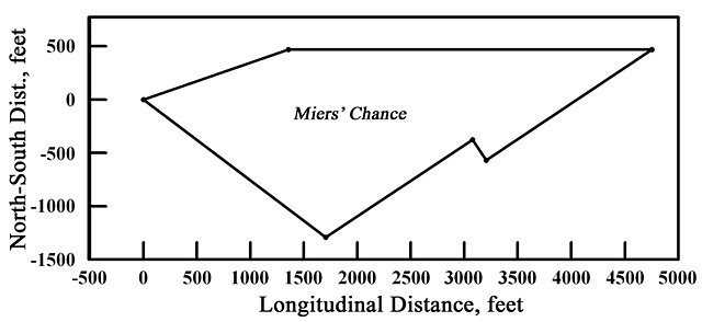
| 364 |
dsl00371-1.jpg dsl00371-2.jpg dsl00371-3.jpg dsl00371-4.jpg dsl00371-5.jpg dsl00371-6.jpg |
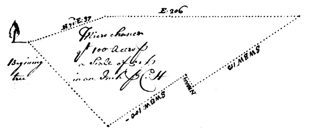
Kent County In Maryland: By virtue of a warrant of sixteen hundred acres
of land granted to Charles Hynson of said county, bearing date at
Annapolis the twenty ninth day of of August last [illegible] one hundred
acres thereof assigned to Stephen Miers of the said county as may
appear, viz.: These are therefore to certify that I, Charles Hynson, Deputy Surveyor of Kent County, have laid out for and in the name of the said Stephen Miers all that tract or parcel of land called Miers' Chance, lying and being in the said county on the North side of the head of Chester River and on the North side of a branch called the Cypress Branch, proceeding out of the head of Chester River: Beginning at a bounded white oak standing on the east side of a branch proceeding out of the said Cypress Branch commonly called Pudding Branch and running from the said oak North seventy one degrees East eighty and seven perches, then East two hundred and six perches, thence South West and by West one hundred perches, then with a straight line to the beginning tree, containing and laid out for one hundred acres of land, more or less, to be held of the Manor of Baltimore this twelfth day of December, Anno [Domini] 1720. Charles Hynson, Deputy Surveyor, Kent County
Kent County In Maryland: I do
assign to Stephen Miers of said county one hundred acres of land, part
of a warrant of sixteen hundred twenty and [illegible] acres dated at
Annapolis the twenty ninth day of August last past, as may appear with
all my right, title, and interest to the same, as witness my hand this
tenth day of December Anno [Domini] 1720.
Charles Hynson
|
|
||||||
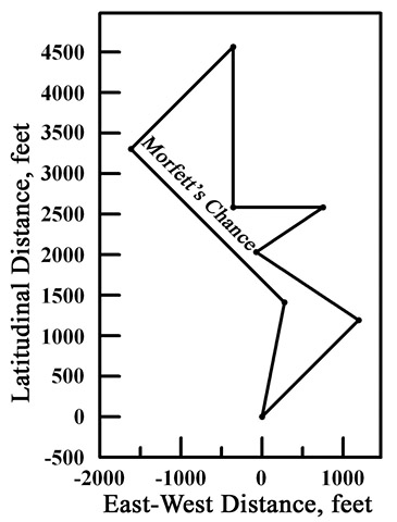
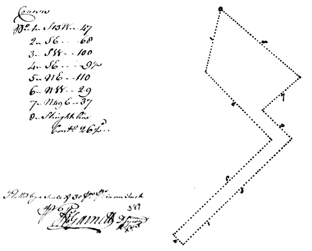
| 388 |
dsl00397-1.jpg dsl00397-2.jpg dsl00397-3.jpg dsl00397-4.jpg dsl00397-5.jpg |
Maryland: Lay out for Mr. Gideon Pe[a]rce of Kent County one hundred acres of land, he having given [illegible] for the same ... As appears in any part of this province not formerly laid out for nor cultivated by any person nor lands reserved for his Lordship's use and return your certificate of survey there of which the name of the place, in what county it lieth, and of what Manor to be held into his Lordship's Land Office by the ... first ... day of July ... next thence to be transmitted to the Examiner General for due examination and for your so doing this shall be your warrant ... Given under his Lordship's lessor sealat arms this 31st ... day of December ... Anno Domini 1724. To his Lordship's Surveyor of this province: March the 2nd, 1725/4
I do assign over the within warrant to George Murphy of Kent County as witness my hand the day and year above written.
Gideon Pearce
Testis:
[illegible phrase]
William Pearce Edward Burrish To be laid on the vacant land lying between The Flower of the Forrest and Smith's land, called ... {? - GL,III, ed.] Kent County In Maryland: By virtue of a warrant of one hundred acres of land granted to Gideon Pearce of Kent County, gentleman, bearing date at Annapolis the thirty first day of December last past, and by the said Pearce assigned to George Morfett as by the same warrant may appear, etc.: These are therefore to certify that I, Charles Hynson, Deputy Surveyor of Kent County, have laid out for and in the name of the said George Morfett all that tract or parcel of land called Morfett's Chance, lying and being in the said county: On the North side of Chester River, beginning at a bounded red oak, being the first bounded tree of a parcel of land called The Flower of the Forrest, and running from the said oak North East one hundred and two perches, then North West and by West ninety two perches, then North East and by East sixty perches, then West sixty seven perches, then North one hundred and twenty perches, then South West one hundred and eight perches, then South East one hundred and sixty two perches, then with a straight line to the beginning tree, containing and now laid out for sixty one acres more or less, to be held of the Manor of Baltimore this twenty eighth day of June, Anno [Domini] 1725. Charles Hynson, Deputy Surveyor, Kent County
|
|
||||||
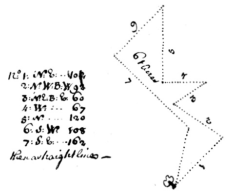
| 389 |
dsl00398-1.jpg dsl00398-2.jpg dsl00398-3.jpg |
Kent County, Maryland: By virtue of a common warrant granted unto Luke
Myers of Kent County, bearing date the 29th day of July 1759, for the
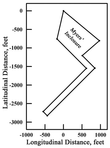
quantity of twenty acres, as by the said warrant may appear, etc.: These are therefore humbly to certify that I, Thomas Garnett, Deputy Surveyor of Kent County (under Benjamin Young, Esq., Surveyor General of the Eastern Shore of Maryland) have carefully surveyed and laid out for and in the name of him, the said Luke Myers, all that tract of land called Myers Inclosure: Beginning at a white oak, the boundary of Myers [Miers] Chance, and running thence South thirteen degrees West forty seven perches, then South East sixty eight perches, then South West one hundred perches, then South East nine perches and one half perch, then North East one hundred and ten perches, then North West twenty nine perches, then North forty nine degrees East thirty seven perches, thence with a straight line to the beginning, containing twenty six acres and one half acre of land more or less, to be held of his Lordship's Manor of Baltimore in Kent County this 1st day of August Anno Domini 1759. Thomas Garnett, Deputy Surveyor, Kent County
|
rearranged to fit the present format. |
||||||
| 390 |
dsl00399-1.jpg dsl00399-2.jpg dsl00399-3.jpg |
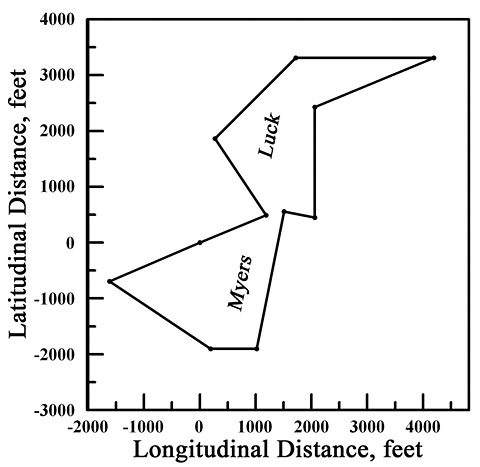
Myers Luck Kent County Maryland: It is by virtue
of the special warrant of survey granted unto Luke Myers of Kent County
bearing date the 25th day of March 1751 found on his Lordship's
proclamation to affect the vacant land included in John Falconar's
resurvey made on his part of The Hope on the third day of June 1746 as by the said warrant may appear:
These are therefore humbly to certify that I, George Garnett, Deputy Surveyor of Kent County under the Hon. Benjamin Tasker, Junior, Esquire, Surveyor General of the Eastern shore of Maryland, have carefully resurveyed and laid out for and in the name of him, the said Luke Myers, all the aforesaid parcel of land now called Myers Luck, lying in Kent County aforesaid:Beginning at the end of the East North East line of John Falconar's part of The Hope and running thence East North East seventy eight perches, then North West by North one hundred perches, then North East one hundred twenty four perches, then East one hundred and fifty perches, then West South West one hundred and forty perches, thence South one hundred and twenty perches, then West by North thirty four perches, then South one hundred and twenty perches, then West by North thirty four perches, then South by West one hundred and fifty two perches, then West fifty perches, then North West by West one hundred and thirty two perches, thence with a straight line to the beginning, containing and now surveyed for two hundred acres of land more or less; to behold his Lordship's Manor of Baltimore in Kent County this 29th day of May seventeen hundred and fifty one. George Garnett, Deputy Surveyor, Kent County
To the humble his Lordship's agent: I do further certify that there is contained on the within survey about 12 acres of cultivated ground with some fence thereon, one very old square logged dwelling house, one very old round log tobacco house, [and] seven scattering apple trees. And also that the said land lies adjoining to lands granted on his Lordship's instructions for taking up his border forest lands: at forty shillings, [one] hundred pence caution money. Test: George Garnett, Deputy Surveyor, Kent County 29 May 1751.
I have received the sum of ten pounds for the within land and one pound for the improvements; patent may therefore issue. 17 March
1753
Benjamin Tasker
|
|
||||||
| 475 |
dsl00486-1.jpg dsl00486-2.jpg dsl00486-3.jpg |
Kent
County, Maryland: By virtue of a special warrant granted unto Joshua
Vansant of Kent County bearing date the 7th day of May 1763, for the
quantity of twenty acres of land lying and being in Kent County
aforesaid and between the following tracts of land, viz.: Nicholas
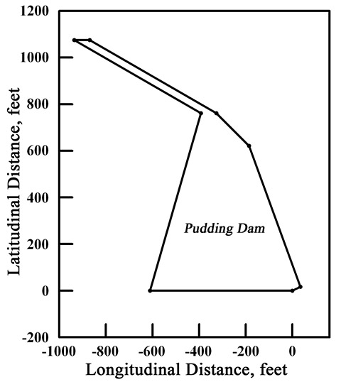
Massey's Slipe, Massey's Venture, and Addition to Fair Dealing, partly cultivated, as by the said warrant may appear, etc.: These are therefore humbly to certify that I, Thomas Garnett, Deputy Surveyor of Kent County (under Benjamin Young, Esq., Surveyor General of the Eastern Shore of Maryland) have carefully surveyed and laid out for and in the name of the said Joshua Vansant a parcel of land called Pudding Dam, lying and being in Kent County aforesaid: Beginning at a hickory tree being the beginning tree of a tract of land called Addition to Fair Dealing and running thence West thirty seven perches, then [illegible] North sixteen degrees East forty eight perches, then North sixty degrees West thirty eight perches, then East four perches, then South sixty degrees East thirty eight perches, then South East twelve perches, then South twenty degrees East thirty nine perches, thence with a straight line to the beginning, containing six acres of land more or less, to be held of his Lordship's Manor of Baltimore in Kent County this 19th day of September, Anno Domini 1763. Thomas Garnett, Deputy Surveyor, Kent County
|
|
||||||
| 526 |
dsl00537-1.jpg dsl00537-2.jpg dsl00537-3.jpg |
Kent
County, Maryland: By virtue of a special warrant granted unto Joshua
Vansant of Kent County, bearing date the 6th day of September, 1763, for
the quantity of fifty four acres and three quarters of an acre, lying
and being in Kent County aforesaid and joining to the Slipe Alongside Massey's Venture, and to the Addition to Fair Dealing, Massey's Venture, and The Exchange, partly cultivated, as by the said warrant may appear, viz.: These are therefore humbly to certify that I, Thomas Garnett, Deputy Surveyor of Kent County (under Benjamin Young, Esq., Surveyor General of the Eastern Shore of Maryland) have carefully surveyed and laid out for and in the name of him, the said Joshua Vansant, a parcel of land called Slipe, lying and being in Kent County aforesaid: Beginning at the end of one perch South from a hickory, the beginning of The Slipe Along[side] Massey's Venture, and running thence West one hundred and eleven perches, then North one perch, then West fifty one perches, then South West nine perches, then East one hundred sixty and eight perches, thence with a straight line to the beginning, containing six acres and one half acre of land, more or less, to be held of his Lordship's Manor of Baltimore in Kent County this 19th day of September, Anno Domini 1763. Thomas Garnett, Deputy Surveyor of Kent County
|
|
||||||
| 527 |
dsl00538-1.jpg dsl00538-2.jpg dsl00538-3.jpg dsl00538-4.jpg |
Whereas
there was a warrant for fifty acres of land granted to Peter Massey and
Nicholas Massey bearing date, the 19th of March 1729, and executed
according to the and by these presents released, acquitted, and
discharged, and [illegible] all my right, title, property
that I, the said Peter Massey and of right or interest may have to the
above said Nicholas, humbly pray that said patent may be made out in the
same, 1741. Peter Massey
Testes:
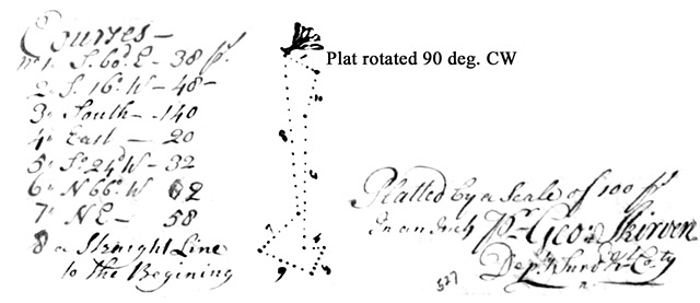
Gideon Pearce Kent County, Maryland: By virtue of a special warrant granted unto Peter and Nicholas Massey of said county for the quantity of fifty five acres of land bearing date, the 19th of March last, as by said warrant may more fully appear, etc.: These are to certify that I, the subscriber, have surveyed and laid out for the said Peter and Nicholas Massey a small parcel of land called The Slippe Along the Side of Massey's Venture. Beginning at a bounded hickory standing at the end of the East line of a parcel of land now in possession of the said Nicholas Massey called Massey's Venture, lying in Kent County aforesaid near the side of a branch that runs out of Chester River and running from said hickory South 60 degrees East thirty eight perches, then South 16 degrees West forty eight perches, then South one hundred and forty perches, then East twenty perches, then South 24 degrees West thirty two perches, then North 66 degrees West sixty two perches, then North East fifty eight perches, thence with a straight line to the beginning, containing and now laid out for twenty five acres of land more or less, whereon is contained about three acres of cleared ground in a long slippe with an indifferent oak rail fence along one side of the same ground, one /post in the ground/ clabboarded thirty foot long indifferent old dwelling house, one ten foot long boarded house, and one small log corn house, etc. The said land to be held of the Manor of Baltimore in Kent County this 30th March, 1730. George Skirven, Deputy Surveyor, Kent County
|
This is another, second certificate for the same survey, with the same date. See Certificate No.192 |
||||||
| 544 |
dsl00555-1.jpg dsl00555-2.jpg dsl00555-3.jpg |
Kent
County, Maryland: By virtue of a warrant of two hundred and seventy
acres of land granted to Gideon Pearce of said county, bearing date at
Annapolis the 10th day of April last past as may appear, etc.: These are to certify that I, Charles Hynson, Deputy Surveyor of said county, have laid out for and in the name of the said Gideon Pearce all that tract or parcel of land called Spring Garden, lying and being in the said county on the South side of Sassafras River, beginning at a marked red oak standing on the West side of the road that leads from the head of Chester to the head of Sassafras and running from the said oak North forty eight perches, then East one hundred and fifty six perches, then North one hundred perches, then East one hundred and seventy two perches, the South sixty five degrees East one hundred twenty six perches, then South thirty five degrees West thirty seven perches, then South forty nine degrees West sixty perches, then South sixty six degrees West sixty four perches, thence with a straight line to the beginning tree, containing and now laid out for two hundred sixty five acres of land more or less, to be held of the Manor of Baltimore this third day of October, Anno Domini 1722. Charles Hynson, Deputy Surveyor of Kent County
|
| ||||||
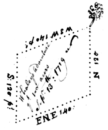
| 621 |
dsl00638-1.jpg dsl00638-2.jpg dsl00638-3.jpg |
Maryland: By virtue of a warrant of four hundred acres of land granted
unto James Harris, Es., of Kent County, bearing date the ninth day of
September instant, one hundred acres of land assigned to Daniel Whaley
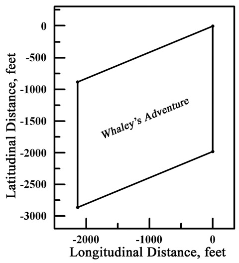
of said county as may appear: These are to certify that I, Charles Hynson, Deputy Surveyor of Kent County, have laid out for and in the name of the said Daniel Whaley all that tract or parcel of land called Whaley's Adventure, lying and being in Kent County on the East side of Chesapeake Bay and on the North side of a river called Chester River and on the South side of a branch in said river called Cypress Branch: Beginning at the South East corner of a parcel of land called Fair Dealing, formerly laid out for John Salter and running from the said South East corner of [Fair] Dealing West South West one hundred and forty perches, then South one hundred and twenty perches, then East North East one hundred and forty perches, then with a straight line to the first beginning, containing and now laid out for one hundred acres of land more or less, to be holden of the Manor of Baltimore [illegible.] Witness my hand this 13th day of October, 1719. Charles Hynson, Deputy Surveyor, Kent County
|
The southeast corner of Fair Dealing coincides with the beginning tree (see sketch) of Whaley's Adventure. |

| Land Transaction | Plat Derived from Deed | |||
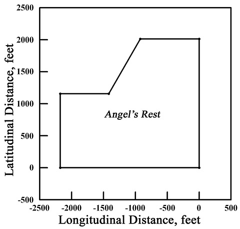
| David Witherspoon to Daniel Massey, March 21, 1755: Angel's Rest ... all that parcel of land being part of a tract of land called Angels Rest,
lying and being in Kent County on the North side of Chester
River. Beginning at the end of the third line of the [illegible]
original tract and running from thence North one hundred and twenty and
two perches, then West fifty and six perches to the great road leading
from [illegible] head of Sassafras River to the head of Chester River,
then South thirty degrees West with said road sixty perches then West
forty and six perches,, then South seventy perches to the third line of
the [illegible] then running East to the beginning. Containing and laid
out for eighty acres of land more or less unto said Daniel Massey ...
... and whereas disputes have been likely to arise on account of the lines of the aforesaid Angels Rest interfering with the land of the said Daniel Massey called Partnership now the aforesaid David Witherspoon doth remiss, release, and forever quitclaim unto said Daniel Massey, his heirs, and assigns, forever all the estate, right, title, or property, either in law or equity, which he the said David Witherspoon, his heirs, executors, or administrators have, ought, or could have to that part of Angels Rest lying and being within said Daniel Massey's claim of the aforesaid tract of land called Partnership ... ... Daniel Massey, his heirs, and assigns, shall and may at all times forever hereafter peaceably and quietly have, hold, occupy, posses,s and enjoy the aforesaid granted lands and premises without the lett, hindrance, molestation, interruption, or denial of him the said David Witherspoon, his heirs, executors, and administrators, and of all and every other person or persons who whatsoever claiming or to claim any right, title, interest, or property by, from, or under him the said David Witherspoon, his heirs, executors, administrators, and by, from, or under a certain Bryant Amoly ... |
 |
|||
| Thomas Witherspoon to Elijah Massey, March 19, 1771: Angel's Rest ... all that parcel of land being
part of a tract of land lying in Kent County in the province of
Maryland between Sassafras and Chester Rivers called Angels Rest,
the aforesaid granted parcel thereof lying between John Carslocks and
Jacobs Galifons part of the aforesaid tract. Beginning at the end of the
North line of John Carslocks part of Angels Rest
according to a partition thereof heretofore [illegible] and running
thence North fifty three perches and one quarter of a perch thence East
four hundred and twenty perches thence South fifty three perches and one
quarter of a perch then with a straight line to the first beginning,
containing and now laid out for one hundred thirty nine and one half of
an acre of land ...
... Thomas Witherspoon for himself and his heirs does further grant and covenant to and with the said Elijah Massey, his heirs, and assigns, that he the said Thomas Witherspoon and his heirs the said granted parcel of land and premises with the appurtenances in every part thereof as well himself and his heirs is against all and every of their heirs of a certain Bryan Omeally and against any person or persons claiming or to claim by from or under them or any of them as also against all manner of person or persons whatsoever laying any lawful claim to the same ... |
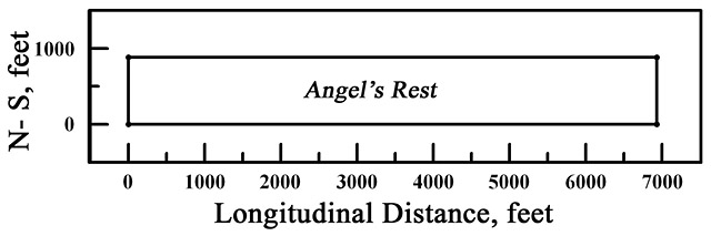 Note: The 1771 plat of Angel's Rest
has a longitudinal dimension more than twice as great as does the 1755
plat, but I have not yet found a Certificate for any parcel called Angel's Rest; all that notwithstanding, the Witherspoon family and a fellow called Bryan[t] Omealy [Amoly] still connect them - GL,III, ed.
|
|||
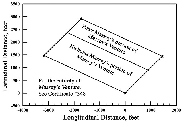
| Peter Massey and Nicholas Massey, Jr., division, March 16, 1718: Massey's Venture ...The
aforesaid Peter to have that part next adjoining onto the plantation
where he now lives beginning at a bounded White Oak being the East most
bounded tree of a parcel called Well Meaning and the beginning tree of the aforesaid land called Massey's Venture
and then running from the said tree North sixty five degrees West two
hundred and twelve perches thence North East seventy seven perches
thence South 65° East two hundred and twelve perches then to the
aforesaid bounded tree containing one hundred acres of land more or less
...
Note: Well Meaning lies to the east of the northernmost point of the divided Massey's Venture, and Peter Massey apparently lives on Well Meaning, which lies to the north and east of Massey's Venture. However, see |
 |
|||
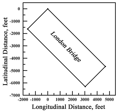
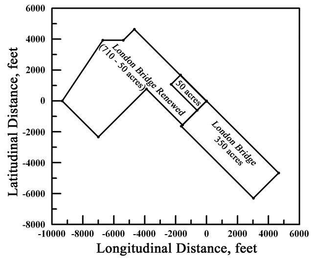
| John Toaes (Toas) to Sarah Massey, May 12, 1709: London Bridge Know all men by these presents
that I John Toaes, late of Kent County in the province of Maryland for
diverse good causes and considerations am herewith moving but more
especially for and in consideration of brotherly love and affection
actions I have onto Sarah Massey the new wife of Peter Massey formerly
Sarah Toaes, have given, granted, released, and confirmed to be as by
these presents I do give, grant, alienate, release, and confirm unto
Peter Massey and his heirs all that tract or parcel of land whereon he
now lives, lying upon the head of Chester River being part of a tract of
land called London Bridge:
Beginning at a white oak standing on the side of a valley [illegible]
half a mile up the [blank] from Peter Massey towards the land
[illegible] running South West one hundred and forty perches, then South
East four hundred perches, then North East one hundred and forty
perches, then North West four hundred perches to the first bounded tree
containing by estimation three hundred and fifty acres. ...
|
 |
|||
| Daniel Massey to Henry Clark, June 9, 1758: 50-acre part of London Bridge Renewed ...Witnesseth that the said Daniel
for and in consideration of the sum of twenty pounds paid to his father
Peter Massey by a certain John Clark, father of the aforesaid Henry for a
certain quantity of fifty acres of land sold by the said Peter to the
same [illegible] to be part of a tract of land called London Bridge
may more fully appear by a deed recorded in Kent County records, which
land has since been found vacant. Now the same Daniel having taken up
the same land and complied with all requirements having his Lordships
patent of confirmation for the said land and being willing to do
acquaint and justice to the same Henry doth by these presents rent,
bargain, sell, alienate, enfeoff, and confirm unto this said Henry Clark
the aforesaid land, being part of a tract or parcel of land now called London Bridge Renewed. Beginning at the North East corner of said land and being the North corner of the land formerly called London Bridge
and running from thence South West fifty two perches than North West
one hundred and forty four perches then North East fifty two perches
then to East one hundred forty four perches to the first place of
beginning, containing and now laid out for fifty acres of land more or
less ...
Note: In order to fit these three parcels London Bridge, London Bridge Renewed, and the present 50-acre portion of London Bridge Renewed into context, I have replatted London Bridge Renewed so that all three parcels have the same starting point, the bounded white oak in the deed for London Bridge. I don't know whether it's coincidence or not, but the zero-latitude starting points for London Bridge and London Bridge Renewed coincide - On the other hand, perhaps the entire right-hand leg of London Bridge Renewed coincided with the entirety of London Bridge - It's the ambiguity of the term, "North East corner" (of London Bridge Renewed) that causes this problem - GL,III, ed. |
 |
|||
| Daniel Toas Massey to Abraham Woodland, March 4, 1794: 431.25-acre part of Partnership ...Witnesseth that the said Daniel
Toas Massey for and in consideration of the sum of three thousand and
eighteen pounds fifteen shillings current money to him in hand paid by
the said Abraham Woodland ... part of tract of land called and known by the
name of Partnership which is contained within the following lines and
bounds, to wit: Beginning at a small gum tree standing on the South
prong of a little branch or drain called the Horse Penn Drain and at the
end of three hundred and twenty two perches and one half perch in the
third line of the original tract of land called Partnership and running
from the said tree with said line of Partnership North by East one
hundred and fifty seven perches and one fourth or quarter of a perch to a
stone standing at the South West corner of the lot of the aforesaid
tract of land belonging to the heirs of Joseph Sturgis, deceased, then
on the division line between the said Daniel Toas Massey land and a
certain Joseph Massey land the three following courses to wit: East two
hundred and forty perches to a stone standing at the end of the third
line of a parcel of land which was conveyed by the said Daniel Toas
Massey to the above named Joseph Massey and South eight degrees and
three quarters of the degree West seventy nine perches and one half
perch to another stone, then East one hundred and ninety five perches to
a stone standing on the West side of the main road [now called Route 313
- GL,III, ed.] leading from
Masseys Crossroads [now called just Massey, Maryland - GL,III, ed.] to
Head of Chester [now called Millington, Maryland - GL,III, ed.] and East
two thirds
of the perch to the middle of the aforesaid road, then with the said
road the three following courses to wit: North thirteen degrees East
sixty perches and North twenty two degrees and one-quarter degree
East forty perches, then North thirty degrees and one half of a degree
East one hundred and sixteen perches, then East one perch to a stone
standing in the South line of the original tract of land called
Partnership which said stone was established and agreed by the said
Daniel Toas Massey and his certain Joseph Newman and William Little,
deceased, in his lifetime and a certain James Blackiston and is a
boundary between them South two hundred and sixty nine perches and three
quarters of the perch until it shall intersect the line drawn East from
the aforesaid original place of beginning, then with this said East
line reversed to the aforesaid beginning, containing and now laid out
for four hundred and thirty one acres and one quarter of an acre...
|
|
|||
|
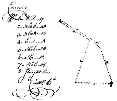
Luke Miers to Joseph Parsons, November 11, 1760 Miers Luck: 178 acres Kent County Maryland: Witnesseth that the said Luke Miers [and Elizabeth, his wife] for and in consideration of the sum of one hundred and ten pounds current money to him in hand paid by the said Joseph Parsons, the receipt whereof he, the said Luke Myers, does hereby acknowledge thereof doth hereby exonerate and discharge the said Joseph Parsons, his heirs and executors and administrators forever more, hath granted, bargained, sold, alienated, released, and confirmed, and by these presents doth grant, bargain, sell, release, and confirm unto him, the said Joseph Parsons, his heirs and assigns, all that part of a tract or parcel of land called Miers Luck: Beginning at a marked black oak standing at the end of the South East and dividing line of the original tract of The Hope, being the beginning of Miers Resurvey and running with said Resurvey East North East seventy eight perches, then North West by North one hundred perches, then North East one hundred and twenty four perches, then East thirty perches, then South one hundred and seventy four perches, then West by North thirty four perches, then South by West one hundred and fifty two perches, then West fifty perches, then North West by West one hundred and thirty two perches, and from thence with a straight line to the first place of beginning,containing and now laid out for one hundred and seventy eight acres of land ... |
|
|||
| Daniel Massey to John Comegys &Elizabeth, his wife, March 22, 1800 London Bridge Renewed: 204 acres Witnesseth that the said Daniel Massey for
and in consideration of the sum of one thousand two hundred and twenty
seven pounds current money of Maryland to him in hand paid by the said
John Comegys and Elizabeth his wife before the sealing and delivery of
these presents, the receipt whereof is hereby acknowledged, hath
granted, bargained, sold, aliened, enfeoffed, released, and confirmed,
and by these presents doth grant, bargain, sell, alien, enfeof, release,
and confirm unto the said John Comegys and Elizabeth his wife all that
part of a tract or parcel of land lying and being in Kent County and
state of Maryland called and known by the name of London Bridge Renewed
which is contained within the following lines and bounds: Beginning at a
stone standing at or near the end of the first line of a tract or
parcel of land described by deed of bargain and sale from Daniel Massy
[Massey] and wife, since deceased, to Gilbert Falconar, since deceased,
and running from said stone North 46° and one half of a degree East
64 perches, then North 28° and one for third quarter of the degree
East 20 perches, then North 24° East 12 perches, then North 14°
and three quarters of the degree East 34 perches, then North 44° of
one half of the degree East 25 perches to the South East line of the
original tract of land called London Bridge Renewed, then with that line
South 48° East 232 perches to Gilpin's Mill Pond, then down by and
with the said mill pond South 51° and three quarters of the degree
West 19 perches, then south 6° and three quarters of the degree West
six perches, thence South 21° East 11 perches, thence South 37°
and one half of a degree West eight perches, thence South 80° West
14 perches, then North 76° and one half of the degree West eight
perches, thence South 30° west 52 perches, thence South 76° East
54 perches, thence South 42° and three quarters of the degree East
eight perches to the mill race, thence South 67° and one half of the
degree West 16 perches, then North 48° West 55-1/2 perches to the
little mill pond, and up by and with the same North 4° West 12
perches, then North 71° West 11 perches, then North 46° and one
half of a degree East nine perches, then North 15° east 19 perches,
then North 11° and one quarter of a degree West 14 perches, then
North 53° and one quarter of a degree West eight perches, then North
16 degrees West 16 perches, then North 9° East four perches, then
North 16° and three quarters of the degree West eight perches and
one quarter of a perch to a white oak tree standing by the side of the
said pond, then across the said pond south 72° and three quarters of
the degree West 16 perches and one half of a perch, then down the said
pond on the West side thereof and binding with the same South 62° and
one half of the degree East 12 perches, then South 14° and three
quarters of the degree West 14 perches, then South 6° East 16
perches, thence South 39° and one half of degree East 16 perches,
thence South 55° West 25 perches and one third of a perch to the
second line of the said tract of land described by the said deed of
bargain and sale from the said Daniel Massy [Massey] and wife since
deceased to the said Gilbert Falconar since deceased, and then with that
line to the aforesaid place of beginning, containing and now laid out
for 204 acres and one half of an acre of land more or less ... or in any wise appertaining (except the burial
ground thereon containing thirty square feet of ground which is hereby
reserved to the said Daniel Massey and his heirs with free ingress
egress and regress into and from the same at all times hereafter) ...
Note by GL,III, Editor: The presence of two portions of Gilpin's Mill Pond along the boundaries of London Bridge Renewed in the March 22, 1800 deed made it easy to correlate those boundaries with the orthophotographic Millington Quadrangle of 1988 provided by Johns Hopkins University; the composite image at bottom right shows a small portion of this map and its scales along with the boundaries of London Bridge Renewed; there is remarkable coincidence of the 1988 land lines and wetlands with the 1800 survey (platted from the London Bridge Renewed deed with the help of PSI-Plot, a spreadsheet-based mathematics assistant). Any doubters can refer to the same area shown with Google Earth (where London Bridge Renewed is centered on the coordinates 39°16'04.00 N, 75°49'58.51 W). |
|
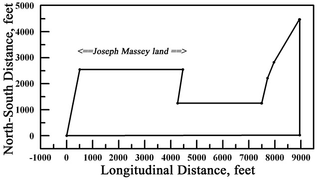
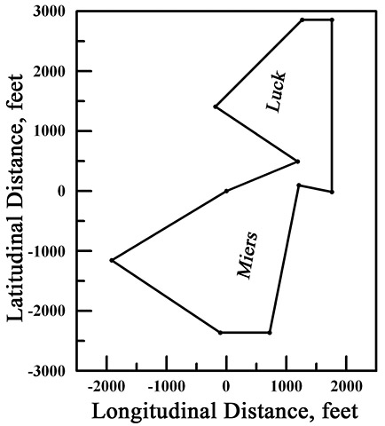
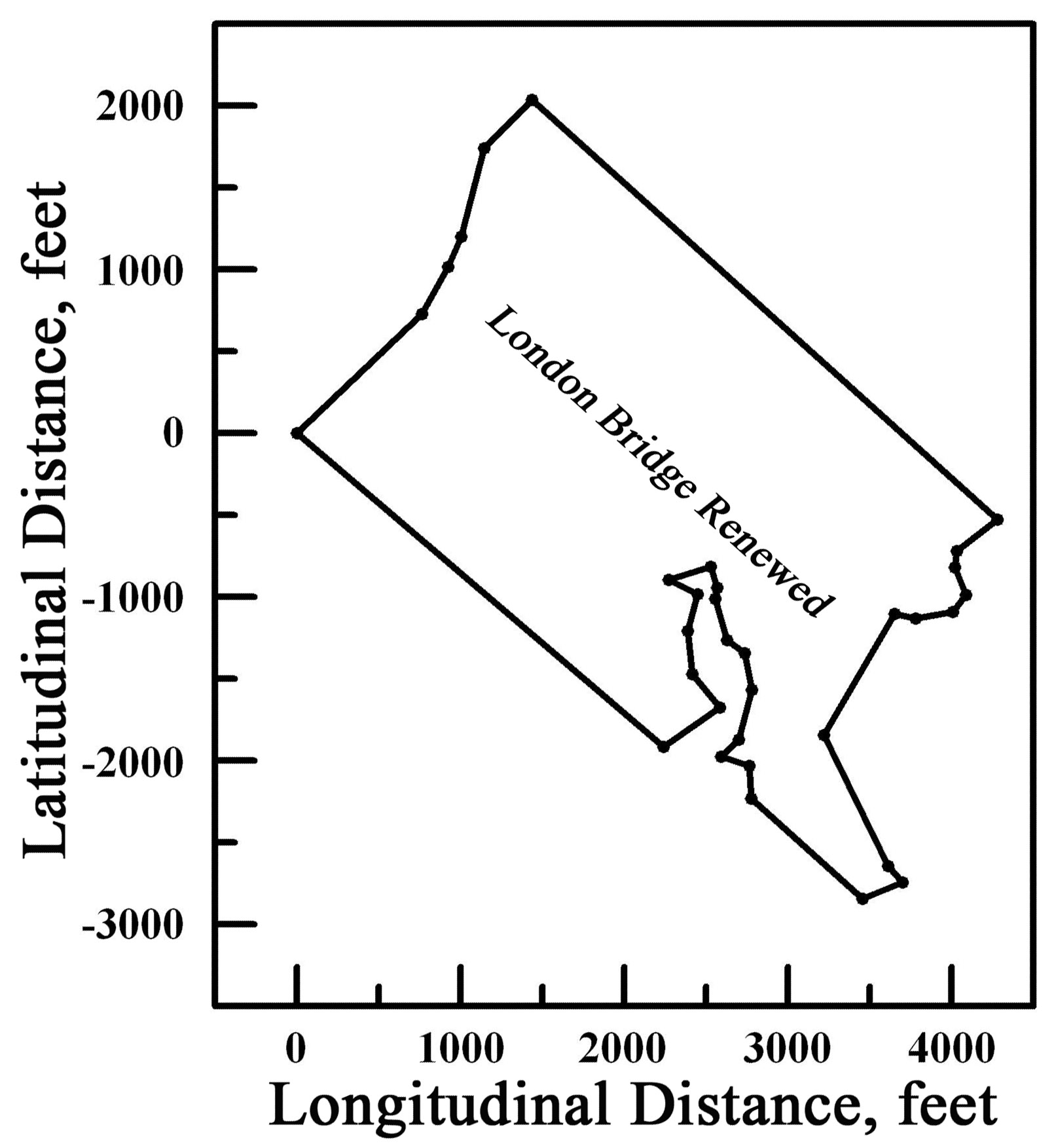
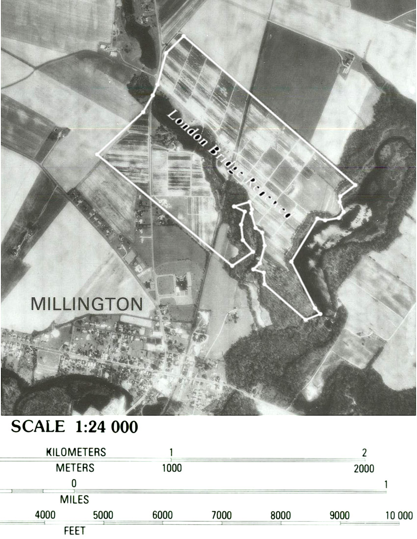