Date
|
Parcel
|
1675/01/08
|
|
Grantor
|
Grantee
|
Parcel
|
Acreage
|
Lib:No:Fol
|
Type
|
Charles Ballard, on behalf of Thomas Harwood
|
Toage Riggin
|
Golden Lyon
|
700
|
WW:095
|
Mortgage to Secure a Debt
|
January
8, 1675: Charles Ballard of Somerset County in the Province of Maryland
finds himself bonded to Toage Riggin, also of Somerset County, to the
tune of twenty eight thousand five hundred pounds of good, sound,
merchantable tobacco on behalf of Thomas Harwood for the consideration
of fourteen thousand two hundred and fifty pounds of good, sound,
merchantable tobacco as payment for the tract of land called the Golden
Lyon, lying on the Eastern Shore by the Pocomoke River near
Moremsco
Creek adjoining to the said river and on the East side of the said
creek and enclosed within the following metes and bounds: Beginning at
a marked cedar standing South and running along the creek side by a
line drawn North two hundred and ten perches to a marked oak, then
running into the woods by a line drawn East five hundred and thirty
four perches to a marked oak for length and running with a line drawn
by said oak South to a marked pine two hundred and twenty perches,
thence drawing a line West down to the creek side to the first marked
cedar five hundred twenty five perches, containing seven hundred acres,
with the condition of this obligation that if the above bound Charles
Ballard shall and will (on the behalf of the aforenamed Thomas Harwood)
give the above named Toage Riggin within ten days of these presents
full and complete possession of the aforementioned seven hundred acres,
then this obligation shall be null and void. Witnesses: Thomas Highway
and William Stevens; Tom. Beauchamp is Somerset County clerk.
|
| 1676/09/04 |
|
Grantor
|
Grantee
|
Parcel
|
Acreage
|
Lib:No:Fol
|
Type
|
| Capt. Thomas Harwood & wife Mary Harwood
|
Toage Riggin |
Golden Lyon |
700
|
WW:145 |
Deed
|
September
4, 1676: Captain Thomas Harwood and his wife Mary Harwood,
mariner of London, sell for twelve thousand five hundred pounds of
tobacco to Toage Riggin, planter of Somerset County in the Province of
Maryland, the tract called Golden Lyon, lying in Somerset County on the
Eastern Shore by the Pocamoke River and Moremsco Creek adjoining to the
said river and on the East side of said creek and enclosed by the
following metes and bounds: Beginning at a marked cedar standing South
and running along by the creek side by a line drawn North two hundred
and ten perches to a marked oak, thence running into the woods by a
line drawn East five hundred and thirty four perches to a marked oak
for length and running a line from the said oak South to a marked pine
two hundred and twenty perches, and thence drawing a line West down to
the creek side to the first marked cedar five hundred and thirty four
perches, containing seven hundred acres. Acting as attorneys for the
Harwoods: Charles Ballard and David Browne, both of Somerset County.
Witnesses: Francis Finch, Walter Danah, John Smith and Charles
Baltemore.
|
1688/01/01
|
|
Grantor
|
Grantee
|
Parcel
|
Acreage
|
Lib:No:Fol
|
Type
|
Matthew Scarborough
|
|
North Petherton
|
500
|
NS:B:634
22:392 |
Patent
|
1688:
North Petherton -
Matthew Scarborough - 500 acres in Worcester
County.
|
169?
|
|
Grantor
|
Grantee
|
Parcel
|
Acreage
|
Lib:No:Fol
|
Type
|
Samuel Layfield
|
William Marsey
|
|
|
L:007
|
|
|
169?
|
|
Grantor
|
Grantee
|
Parcel
|
Acreage
|
Lib:No:Fol
|
Type
|
John Massey & wife
|
Thomas Davis
|
|
|
L:376
|
|
... not located ...
|
170?
|
|
Grantor
|
Grantee
|
Parcel
|
Acreage
|
Lib:No:Fol
|
Type
|
| Samuel Layfield & Priscilla Layfield
|
William Massey |
Carmell |
|
GI:26 |
|
|
1723/05/02
|
|
Grantor
|
Grantee
|
Parcel
|
Acreage
|
Lib:No:Fol
|
Type
|
John Tumstall
|
|
Long Meadow
|
248
|
Pat. cert. 1500
|
Patent
|
May
2, 1723: Long Meadow - John Tumstall, 248 acres - there are two other
parcels called Long Meadow: one patented in August, 1747; the other in October, 1747.
|
1734/08/20
|
|
Grantor
|
Grantee
|
Parcel
|
Acreage
|
Lib:No:Fol
|
Type
|
Atkins Marcy
|
John Marcy
|
North Petherton
|
[not stated]
|
AZ:168-168a
|
Bonded Division
|
August 20, 1734: Atkins Marcy of
Somerset County executes his bond to John Marcy to secure the equitable
division of a parcel of land called North
Petherton, situate in Somerset County [North Petherton actually
lies in Worcester
County - GL,III, ed.] in the Province of Maryland, which was
marked by a line of trees about six or seven years ago and now is
marked again by consent of both parties. Witness: Michael Godwin.
|
| 1739/04/05 |
|
Grantor
|
Grantee
|
Parcel
|
Acreage
|
Lib:No:Fol
|
Type
|
Samuel Taylor, George Dawson
& William Dawson
|
John Marsey |
Spring Bank
|
500
|
MF:56,56a
|
Deed
|
April
5, 1739: John Marsey of
Somerset County in the Province of Maryland buys for £62 from Samuel Taylor, George Dawson
& William Dawson of Prince George's County, two-thirds of the 500
acre parcel called Spring Bank lying in
Somerset County [Spring Bank actually lies in Worcester
County - GL,III, ed.] on Indian River. Witnesses: John Addisson,
Ben. Ball, and John Dawson.
|
1743/07/14
|
|
Grantor
|
Grantee
|
Parcel
|
Acreage
|
Lib:No:Fol
|
Type
|
Thomas Right
|
|
Friends Advice
|
40
|
Pat cert. 920
|
Patent
|
July
7, 1743: Friends Advice - Thomas Right, 40 acres - there are two other
parcels called Friends Advice: one patented in 1750; the other in 1771.
|
1747/08/07
|
|
Grantor
|
Grantee
|
Parcel
|
Acreage
|
Lib:No:Fol
|
Type
|
Captain Henry Waggoman
|
|
Long Meadow
|
78
|
Pat. cert. 1501
|
Patent
|
August
7, 1747: Long Meadow - Captain Henry Waggoman, 78 acres.
|
1747/10/01
|
|
Grantor
|
Grantee
|
Parcel
|
Acreage
|
Lib:No:Fol
|
Type
|
| Major Robert J. Henry |
|
Long Meadow
|
646
|
Pat. cert. 1502
|
Patent
|
October
1, 1747: Long Meadow -
Major Robert J. Henry, 646 acres.
|
1747/12/10
|
|
Grantor
|
Grantee
|
Parcel
|
Acreage
|
Lib:No:Fol
|
Type
|
| Teague Riggins |
|
Riggins Amendment
|
285
|
Pat. cert. 2019
|
Patent
|
December
10, 1747: Riggins Amendment - Teague Riggins, 285 acres.
|
1750/07/15
|
|
Grantor
|
Grantee
|
Parcel
|
Acreage
|
Lib:No:Fol
|
Type
|
| Benjamin Transway |
|
Friends Advice |
356
|
Pat cert. 921 |
Patent
|
July
15, 1750: Friends Advice - Benjamin Transway, 356 acres.
|
1755/07/02
|
|
Grantor
|
Grantee
|
Parcel
|
Acreage
|
Lib:No:Fol
|
Type
|
John Newbold
|
|
Carmell
|
119
|
Pat.cert. 441
|
Patent
|
July 2, 1755: Carmell - John Newbold - 119
acres in Worcester
County - See also an earlier Carmel.
|
1756/08/11
|
|
Grantor
|
Grantee
|
Parcel
|
Acreage
|
Lib:No:Fol
|
Type
|
William Tull
|
|
Spring Bank
|
14
|
Pat. cert. 2405
|
Patent
|
August
11, 1756: Spring Bank -
William Tull - 14 acres in Worcester
County.
|
1771/08/16
|
|
Grantor
|
Grantee
|
Parcel
|
Acreage
|
Lib:No:Fol
|
Type
|
William Miles
|
|
Friends Advice |
123
|
Pat cert. 922 |
Patent
|
August
16, 1771: Friends Advice - William Miles, 123 Acres,
|
1783/01/01
|
|
Grantor
|
Grantee
|
Parcel
|
Acreage
|
Lib:No:Fol
|
Type
|
[not found]
|
|
Golden Lyon
|
700
|
[not found]
|
Named parcel
|
1783:
Golden Lyon - See WW:095 and WW:145; referenced
in Maryland State Archives.
Parcels owned in 1783 by David Matthews: 248 acres and 235 acres and
also by Obed Riggen: 100 acres, summing to 583 acres, do not quite
account for Golden Lyon's 700 acres.
|
1832/02/11
|
|
Grantor
|
Grantee
|
Parcel
|
Acreage
|
Lib:No:Fol
|
Type
|
Thomas Marshall
|
Ann Cox
|
Long Meadow
|
37+
|
GH:6:196
|
Deed
|
February 11, 1832: Thomas
Marshall of Somerset County in the State of Maryland sells for $150.00
to Ann Cox, also of Somerset County, the 37+ acre tract called Long Meadow, the real estate of
William Cox, late of Somerset County, by appointment and order of
Chancery Court, in order to settle his debts. Long Meadow lies in
Somerset County near the mouth of Pocomoke River within the following
metes and bounds: Beginning at a marked sassafras post standing at a
corner of the lands of Isaac Riggin, and thence running South one and a
half degrees East seven rods, thence South eighty eight and a half
degrees West thirty seven rods to a marked sassafras post standing at
the North East corner of a tract called Golden
Lyon, thence South one and a half degrees East (by and with the
lands formerly held by the heirs of William Staney (Standy ?) and
Matthias Coston) one hundred and thirty four rods to Tabatha Ward's
land, thence, by and with the said Tabatha Ward's land, East forty four
rods, thence North twenty degrees East thirty and a half rods to a
ditch, thence by and with the said ditch South eighty one degrees West
twenty five rods, thence North five degrees East thirty three rods to a
stone, thence South eighty one degrees East six rods to a marked red
oak, thence North five degrees East eighty seven and a half rods to a
marked cedar post standing on a line of the said Isaac Riggin, thence
by and with said Riggin's land South eighty six and a half degrees West
fifteen rods to the beginning, containing thirty seven acres and one
rood. Witnesses: Justices of the Peace John St. Cohoon and Levin Tyler;
George Stanoz is Somerset County clerk.
|
1854/01/14
|
|
Grantor
|
Grantee
|
Parcel
|
Acreage
|
Lib:No:Fol
|
Type
|
James D. Adams &
wife Leah W. Adams
|
Thomas C. Stephens &
wife Amanda L. Stephens
|
Riggins Amendment
|
[not stated]
|
LW:3:306
|
Deed
|
January
14, 1854: James D. Adams and his wife Leah W. Adams of Somerset County
in the State of Maryland sell for $325.00 to Thomas C. Stephens and his
wife Amanda L. Stephens the tract called Riggins
Amendment which is contained within the following metes and bounds:
Beginning at the first boundary of the aforesaid tract and from thence
running North eighty seven and a half degrees East sixty eight and a
quarter perches to the lands of Thomas Long's heirs, thence with the
said lands South five and a half degrees West [no distance indicated]
to a cedar post on the bank of a new ditch cut about ten perches from a
locust bounder at the said James D. Adams landing, thence by and with
the said new ditch to Moremsco
Creek, thence [illegible] said creek and binding thereon to a gut,
thence up said gut to the beginning bounder [acreage not indicated.]
Also, James D. Adams and Amanda L. Stephens are to grant access by an
existing road leading from the County Road to the said James D. Adams
landing on Moremsco Creek
and to keep said road in good repair. Witnesses: Justices of the Peace
Alfred A. Curtis and Colmore A. McReady; Levin Woolford is Somerset
County clerk.
|
1860/07/21
|
|
Grantor
|
Grantee
|
Parcel
|
Acreage
|
Lib:No:Fol
|
Type
|
Joseph B. Cox & wife Margaret Cox
|
Daniel Boston & wife Enetia Boston
|
Long Meadow
|
37+
|
LW:7:16
|
Deed
|
July 21, 1860: Joseph B. Cox
and his wife Margaret Cox of Worcester County in the State
of Maryland sell for $25.00 to Daniel Boston and his wife Enetia Boston, both
of Somerset County, the 37+ acre tract called Long Meadow,
which lies in Somerset County near the mouth of Pocomoke River and
which was purchased by Ann Cox from Thomas Marshall, trustee appointed
to sell and dispose the real estate of the late William Cox and which
was left by the Last Will and Testament of Ann Cox to her son, the
aforementioned Joseph B. Cox. Witnesses: Justice of the peace for
Worcester County E.L. Maddux and John I. Bound; Levin Woolford is
Somerset County clerk.
|
| 1862/11/10 |
|
Grantor
|
Grantee
|
Parcel
|
Acreage
|
Lib:No:Fol
|
Type
|
| Daniel Boston & wife Enetia Boston
|
Joshua B. Adams |
Long Meadow
|
22
|
LW:7:488
|
Deed
|
November
10, 1862: Daniel Boston and
his wife Enetia Boston sell for $50.00 to Joshua B. Adams all that
parcel (Long Meadow) lying North of
the County Road leading to Shell Town that was conveyed to the said
Daniel Boston by deed from Joseph B. Cox and wife and contained within
the following metes and bounds: Beginning at a marked red oak standing
on the North of said road, and thence running South seven degrees and
fifty minutes East eighty seven and a half poles to a marked maple,
thence South eighty nine degrees West fifteen poles, thence South one
degree West seven pole, thence North eighty nine degrees West thirty
seven poles to a marked red oak, thence South one degree West seventy
four poles to the aforesaid County Road, thence with said County Road
South eighty six degrees East sixteen poles, thence to the beginning,
containing twenty two acres. Witnesses: Tubman C. Langford and Justice
of the Peace Henry W. Matthews; Levin Woolford is Somerset County clerk.
|
1865/05/15
|
|
Grantor
|
Grantee
|
Parcel
|
Acreage
|
Lib:No:Fol
|
Type
|
George B. Dennis, James
N. Hughes, & William F.W. Miles
|
Joshua B. Adams
|
Riggins Amendment, Long
Meadow, & Golden Lyon
|
508.75
|
LW:9:149
|
Deed
|
May 15
1865: George B. Dennis, James N. Hughes, and William
F.W. Miles, commissioners appointed by the Circuit Court for Somerset
County to divide the lands of James D. Adams, late of Somerset County,
deceased, in consideration of the sum of $4,500.00, sell to Joshua B.
Adams all that parcel which constituted the dwelling & plantation
of the said James D. Adams at the time of his death. The tracts include
the parcels called Riggins
Amendment, Long Meadow, and Golden Lyon, totaling 508-3/4 acres and
designated as Lot No.1 in the plat filed with the proceedings of the
said commission, which was surveyed by William F.W. Miles and dated
December 6, 1860. Witness: Justice of the Peace Isaac Gibbons; Levin
Woolford is Somerset County clerk.
|
1865/05/17
|
|
Grantor
|
Grantee
|
Parcel
|
Acreage
|
Lib:No:Fol
|
Type
|
| Joshua B. Adams & wife Margaret A. Adams
|
William Massey |
Riggins Amendment, Long
Meadow, & Golden Lyon |
508.75 |
LW:9:150
|
Deed
|
May
17, 1865: William Massey buys for $5,600.00 from Joshua
B. Adams and his wife Margaret A. Adams the tract
which was conveyed to the Adamses by deed from George B. Dennis,
William F.W. Miles, and James N. Hughes, commissioners
appointed by the Circuit Court and also that tract
which was conveyed to Joshua B. Adams by deed from Daniel Boston
and which adjoins the first tract. Witnesses: Justice of the Peace S.
Wilkins; Levin Woolford is Somerset County clerk. |
| 1866/08/04 |
|
Grantor
|
Grantee
|
Parcel
|
Acreage
|
Lib:No:Fol
|
Type
|
| Thomas C. Stephens & wife Amanda L. Stephens
|
E.J. Adams
|
Riggins Amendment
|
[not stated]
|
LW:10:436
|
Deed
|
August 4,
1866: Thomas C. Stephens
and his wife Amanda L. Stephens sell for $400.00 to E.J. Adams the
tract called Riggins Amendment
situated on Moremsco Creek
whereon Thomas C. Stephens now lives and which he
purchased from James D. Adams. Witness: Justice of the Peace S.
Wilkins; Levin Woolford is Somerset County clerk. |
1870/09/21
|
|
Grantor
|
Grantee
|
Parcel
|
Acreage
|
Lib:No:Fol
|
Type
|
Azariah P. Lankford
|
Samuel Massey
|
Goods & chattels
|
[none]
|
LW:12:364
|
Mortgage to Secure a Debt
|
September 21, 1870: Azariah P. Lankford,
in order to secure a debt of $372.00 to Samuel Massey, executes a
mortgage to Mr. Massey of the following list of goods and chattels: One
bay horse,one grey mare, one yoke of oxen, three cows, one young ox,
three yearlings, eighteen hogs & pigs, eleven sheep, one
[illegible] cart, thirty bushels of wheat, one hundred bushels of oats,
fourteen stacks of fodder, and all my share of the corn in the field,
provided that if I pay to the said Samuel Massey the sum of three
hundred and seventy two dollars with interest thereon on or before the
first day of August, eighteen hundred and seventy one, then these
presents shall be void. Witnesses:
Fert. Keane and Justice of the Peace Henry W. Matthews; Levin L. Waters
is Somerset County clerk.
|
1872/05/20
|
|
Grantor
|
Grantee
|
Parcel
|
Acreage
|
Lib:No:Fol
|
Type
|
Samuel Massey
|
Azariah P. Lankford
|
Goods & chattels
|
[none]
|
LW:13:416
|
Release of M'gage
|
May
20, 1872: Samuel Massey releases the mortgage of Azariah P. Lankford; see LW:12:364. Witness: Loren L. Waters,
Somerset County clerk.
|
| 1872/05/25 |
|
Grantor
|
Grantee
|
Parcel
|
Acreage
|
Lib:No:Fol
|
Type
|
| Edward J. Adams & wife Emily F. Adams
|
Samuel Massey |
[not stated] |
[not stated] |
LW:13:429 |
Deed |
May
25, 1872: Samuel Massey buys for $350.00 from Edward J. Adams and his
wife Emily F. Adams, all of Somerset County, the tract lying in
Somerset County on Moremsco Creek, that
had been conveyed to the said E.J. Adams by Thomas C. Stephens and wife
by deed dated August 1866. Witness: Justice of the Peace Smith
Lankford; Loren L. Wasters is Somerset County clerk. |
| 1874/02/25 |
|
Grantor
|
Grantee
|
Parcel
|
Acreage
|
Lib:No:Fol
|
Type
|
| George A. Phoebus & wife Virginia C. Phoebus
|
Sarah M.E. Massey |
[not stated] |
[not stated] |
LW:14:642 |
Deed |
February
25, 1874: George A. Phoebus and his wife Virginia C. Phoebus sell for
$1,400.00 to Ann E.H. Phoebus, John W. Phoebus, Mary H.J. Phoebus,
Matthias E.W. Phoebus, Sarah M.E. Massey,
Margaret E. Henderson, Ignatius H. Phoebus, and Aurilla J. Phoebus,
the tract that James Phoebus, late of Somerset County, owned and
possessed at his death. Witnesses: Henry G. Budd, Notary Public for the
City of [illegible], Delaware; Levin L. Waters is Somerset County
clerk. [Note: James Phoebus owned about ten different parcels at one
time or another, too many to unscramble here - GL,III, ed.] |
| 1874/09/04 |
|
Grantor
|
Grantee
|
Parcel
|
Acreage
|
Lib:No:Fol
|
Type
|
| Ignatius H. Phoebus, Wilbur F. Massey and his
wife Sarah E.M.P. Massey, George Hudson and his wife Margaret E.
Hudson, Mary H. Phoebus, Anne E. Phoebus, and Aurilla J. Phoebus
|
John W. Phoebus |
[not stated] |
162.5
|
LW:15:615 |
Division |
September
4, 1874: Ignatius H. Phoebus, Wilbur F. Massey
and his wife Sarah E.M.P. Massey, George Hudson and his wife
Margaret E. Hudson, Mary H. Phoebus, Anne E. Phoebus, and Aurilla J. Phoebus,
all of Somerset County in the State of Maryland, petition for a
commission to divide into three parts a tract of land, and also to
determine the annual rental value of the dower right of the widow of
James Phoebus, and then to sell the divisions to whomsoever parties of
this agreement so elect. The tract was accordingly surveyed and Lot
No.2 has the following metes and bounds: 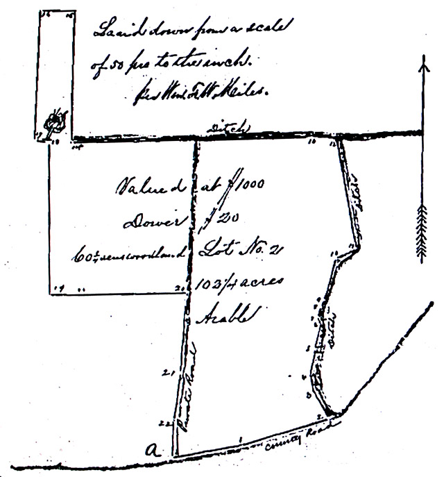 Beginning at the Eastward side
of the private road where it intersects the County Road leading to
Deals Island, at the end of the seventh course of Lot No.1 represented
on the plat by the letter A, thence down the said County Road and
reversing the said seventh course, South seventy nine degrees West
forty two perches, thence South seventy and a quarter degrees West
fifty six perches to the middle of the Lead Ditch and the beginning of
Lot No.3, thence up by and with the middle of the said Ditch and
reversing the courses of Lot No.3 by the following courses, South
twenty nine and three quarter degrees East thirty perches, thence South
twelve degrees East ten perches, then South eight and a quarter degrees
West sixteen perches, then South twelve and three quarter degrees West
fourteen perches, thence South nine degrees East four perches, thence
South nine and a quarter degrees West six perches, thence South twenty
four degrees West four perches, fourteen and a third degrees West two
hundred and fifty four [maybe 25-3/4] perches, thence South seventy
degrees West twelve perches, thence South ten and a half degrees East
sixty eight perches to the out lines of the said lands, thence by and
with the middle of the ditch South eighty nine degrees East fourteen
perches,, thence North eighty eight degrees East one hundred forty six
and three quarter perches to a marked post set up in a red oak stump,
the first bounder of the tract called Friend's
Advice, thence South one degree West seventy eight and a half
perches, thence South eighty eight degrees East twenty one and three
quarter perches, thence North one degree East seventy eight and a half
perches, thence North eighty eight degrees West six and a half perches
to a post by the side of a marked oak, thence North one and a half
degrees West ninety three perches to the end of the eleventh line of
Lot No.1, thence reversing the lines of Lot No.1 by the four following
courses, South eighty nine degrees West eighty two and a half perches
to the Eastward side of the private road, thence by and with the
Eastward side of said road by the three following courses, North three
and a quarter degrees East forty eight perches, thence North seven
degrees East twenty eight perches, thence North half a degree East
twenty four perches to the place of beginning, containing one hundred
and sixty two and a half acres. Witnesses: [too many to list here];
Levin L. Waters is Somerset County clerk. Beginning at the Eastward side
of the private road where it intersects the County Road leading to
Deals Island, at the end of the seventh course of Lot No.1 represented
on the plat by the letter A, thence down the said County Road and
reversing the said seventh course, South seventy nine degrees West
forty two perches, thence South seventy and a quarter degrees West
fifty six perches to the middle of the Lead Ditch and the beginning of
Lot No.3, thence up by and with the middle of the said Ditch and
reversing the courses of Lot No.3 by the following courses, South
twenty nine and three quarter degrees East thirty perches, thence South
twelve degrees East ten perches, then South eight and a quarter degrees
West sixteen perches, then South twelve and three quarter degrees West
fourteen perches, thence South nine degrees East four perches, thence
South nine and a quarter degrees West six perches, thence South twenty
four degrees West four perches, fourteen and a third degrees West two
hundred and fifty four [maybe 25-3/4] perches, thence South seventy
degrees West twelve perches, thence South ten and a half degrees East
sixty eight perches to the out lines of the said lands, thence by and
with the middle of the ditch South eighty nine degrees East fourteen
perches,, thence North eighty eight degrees East one hundred forty six
and three quarter perches to a marked post set up in a red oak stump,
the first bounder of the tract called Friend's
Advice, thence South one degree West seventy eight and a half
perches, thence South eighty eight degrees East twenty one and three
quarter perches, thence North one degree East seventy eight and a half
perches, thence North eighty eight degrees West six and a half perches
to a post by the side of a marked oak, thence North one and a half
degrees West ninety three perches to the end of the eleventh line of
Lot No.1, thence reversing the lines of Lot No.1 by the four following
courses, South eighty nine degrees West eighty two and a half perches
to the Eastward side of the private road, thence by and with the
Eastward side of said road by the three following courses, North three
and a quarter degrees East forty eight perches, thence North seven
degrees East twenty eight perches, thence North half a degree East
twenty four perches to the place of beginning, containing one hundred
and sixty two and a half acres. Witnesses: [too many to list here];
Levin L. Waters is Somerset County clerk. |
1875/09/04
|
|
Grantor
|
Grantee
|
Parcel
|
Acreage
|
Lib:No:Fol
|
Type
|
George H. Lewis
|
John H. Massey
|
House & woodland
|
10
|
LW:15:530
|
Mortgage Deed
|
September 4, 1875: John H. Massey of
Somerset County in the State of Maryland buys from George H. Lewis of
Worcester County the house and lot of land lying on Moremsco Creek in
Somerset County which was willed by Samuel Massey, who had purchased
the property from Ned Adams, and also ten acres of woodland which
George H. Lewis purchased from Joshua Adams adjoining the land of James
Davis and M. Lankford on the Shelton Road. The purchase price is the
requirement that George H. Lewis pay a Note of Hand dated September 3,
1875 and due with interest on January 1, 1876, for which John H. Massey
is security. In case George H. Lewis defaults, then John H.
Massey can sell the present property at public auction with 30 days'
public notice as spelled out in the present deed. Witness: Luke Bratten
and Justice of the Peace J.M. Bratten. J.T. Matthews is Circuit Court
clerk and Lewis L. Waters is Somerset County clerk.
|
|
|
Grantor
|
Grantee
|
Parcel
|
Acreage
|
Lib:No:Fol
|
Type
|
|
|
|
|
|
|
|
|
|
Grantor
|
Grantee
|
Parcel
|
Acreage
|
Lib:No:Fol
|
Type
|
|
|
|
|
|
|
|