Dates
|
|
Source
|
Note
|
Because
this
Texas
land
tract is only a few miles away from oil-producing land,
and because it still, at this date, remains the undivided property of
the whole list of the heirs of 90.Robert
Douglass
Massey, it has had an un-planned effect:- it has kept
these R.D. Massey heirs aware of each other, it has kept up to date
their genealogical records, and it has kept these heirs in touch with
each other, as attempts have been made, over the years, to develop a
financial return from the property; a possibility that still exists as
this book goes to press.[Ed.]
|
|
c.1903
|
Robert
D.
Massey,
with
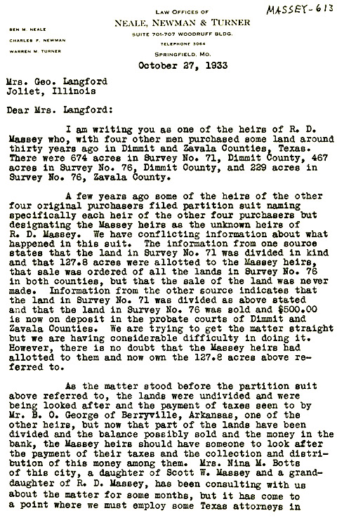
four other men, purchased these land tracts:
674 acres; Survey #71,
Dimmit Co., Texas
|
476 acres; Survey #76,
Dimmit Co., Texas
|
229 acres; Survey #76,
Dimmit Co., Texas
|
The purchasers of this 1,370 acres, together with R.D. Massey, were
surnamed Coxsey, Shadburn, Floyd and George.
|
1; 2
|
7
Nov.1909
|
R.D.
Massey
died
intestate
in Bentonville, Ark.
|
3
|
c.1925
|
The
heirs
of
the
other four original purchasers filed partition suits,
specifically naming each of their heirs, but designating the Massey
heirs as "unknown heirs of R.D. Massey." Apparently, some 515
acres of this land was sold c.1925; leaving 855 acres to be divided
among the five families: 171 acres each, in Dimmit Co. Some $500.
was deposited in the Probate Courts of Dimmit and Zapata Counties for
the R.D. Massey heirs, plus $150. in a bank in Berryville, Ark.
|
1
|
1932
|
Mary
S.
George
sued
R.D. Massey et al in the District court for
partition. The five families were each allotted a one-fifth
interest, 171 acres each, in Dimmit Co.
|
2
|
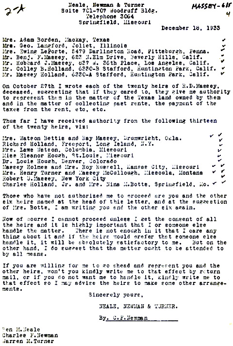
10
Dec.1933
|
A
Springfield,
Mo.
law
firm made the first of many attempts to secure
concerted action by all of the R.D. Massey heirs; twenty by this census.
|
4
|
8
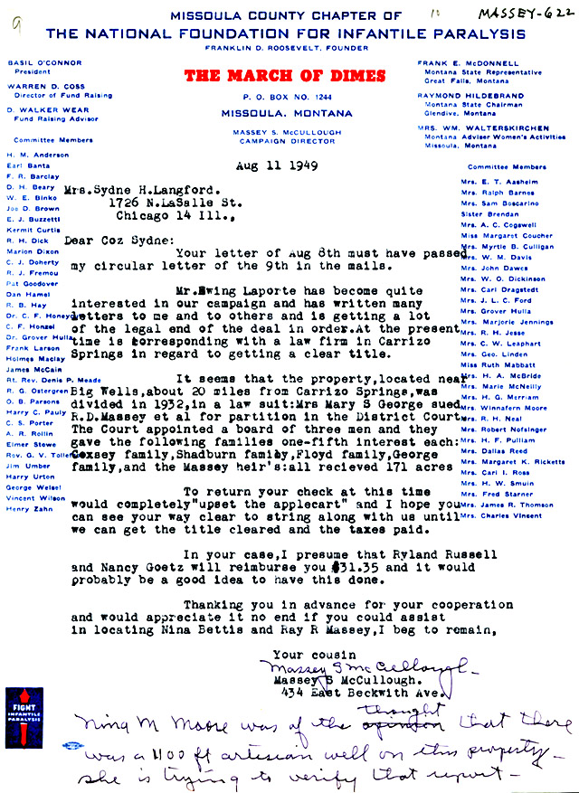
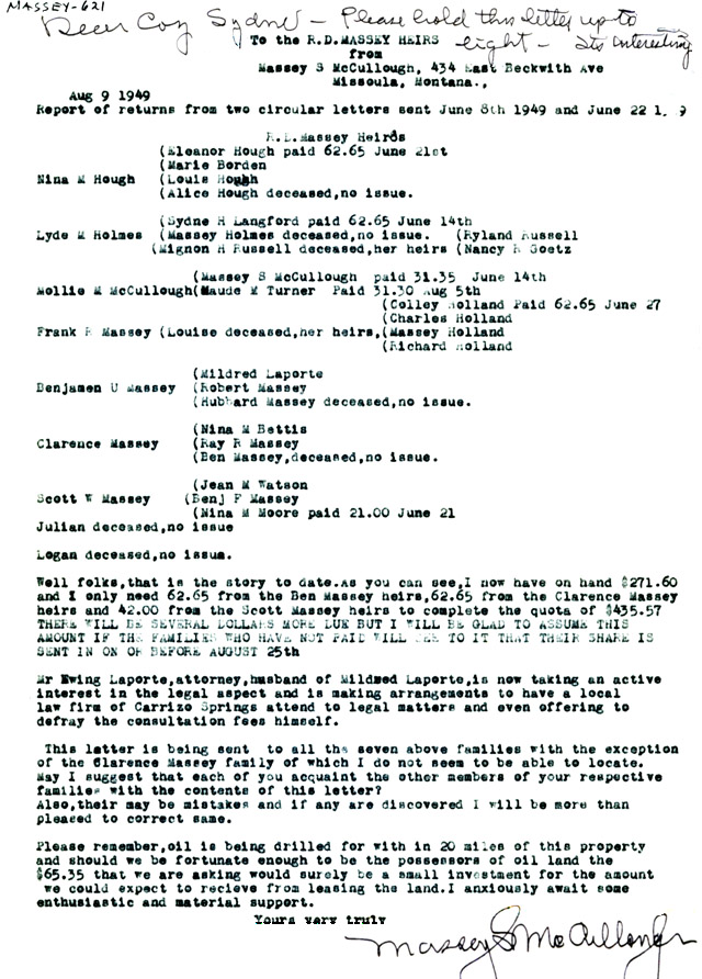
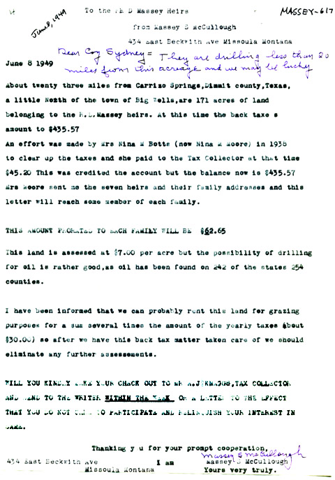
Jun.1949
|
Massey
S.
McCullough,
son
of 47.Mollie Massey
and George T. McCullough assumed the task of getting action from all
R.D. Massey heirs. He writes that their 171 acre share is twenty-three
miles from Carizzo Springs, a little North of Big Wells:
| "Possibility of oil rather
good ... a well was being drilled about twenty miles from Massey
property." |
|
13
|
| 21
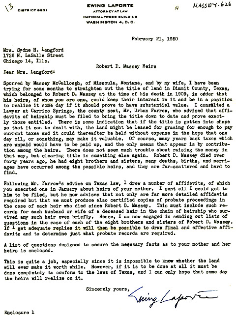
Feb.1950
|
Ewing
Laporte,
a
Washington,
D.C. lawyer, and husband of 212.Mildred
Massey, daughter of 44.Benjamin
Ulpian Massey,
assumes the task of getting concerted action from the R.D. Massey
heirs.
|
14
|
| 4
Mar.1950
|
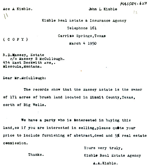
A
potential
purchaser
writes
Massey McCullough, asking for a price for
the land. |
6
|
7
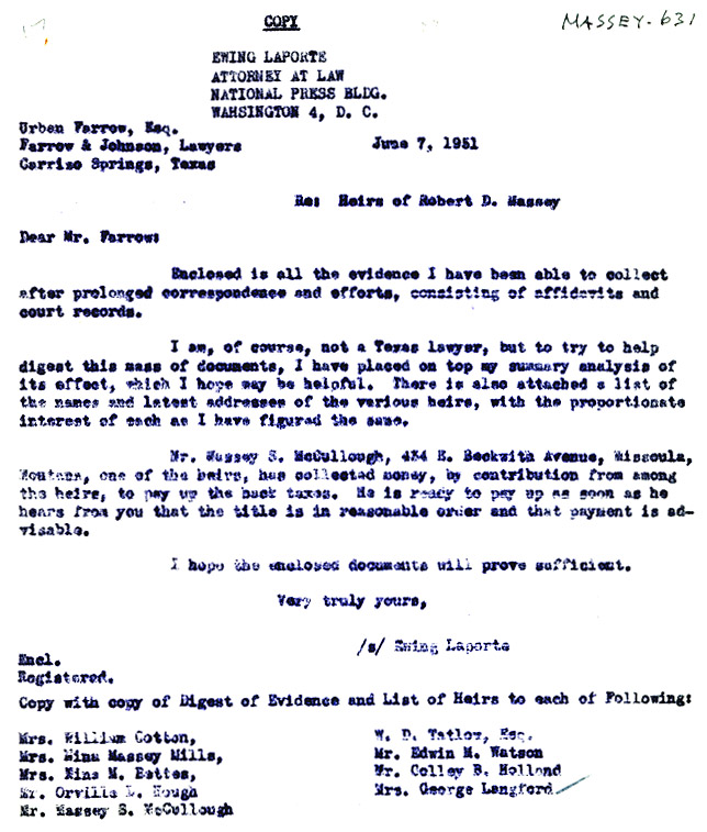
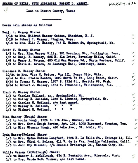
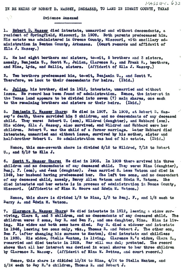
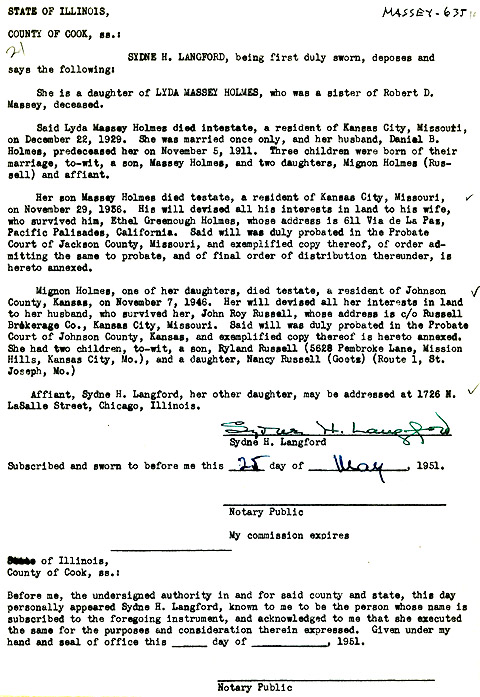
Jun.1951
|
Ewing
Laporte
issues
a
report analyzing each R.D. Massey heir's share of the
Texas land.
|
|
11
Jul.1956
|
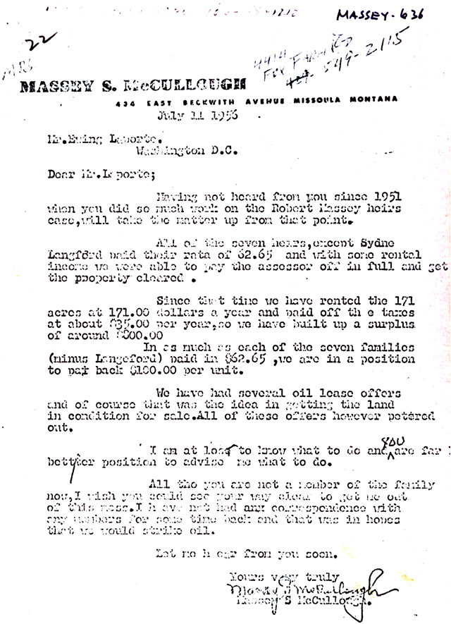
Massey
McCullough
writes
Ewing
Laporte that the 171 acre tract has been leased
for grazing at $1.00 per acre; that the back taxes have been all paid
up; and that an $800 surplus has been accumulated. He also
reported that all oil lease offers have petered out.
|
7
|
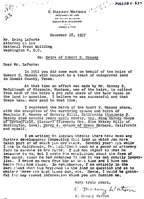
18
Dec.1957
|
E.
Massey
Watson,
of
Columbia, Mo., a son of 216.Jean
Virginia Massey and Samuel
Laws Watson, grandson of 45.Scott
Withers Massey, writes Ewing Laporte for any up-dated information
regarding the Texas property.
|
16
|
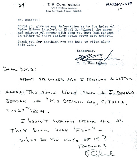
16
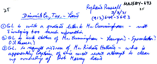
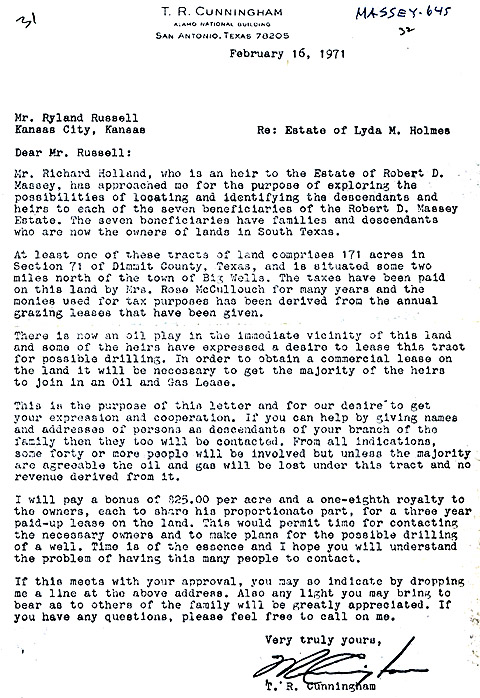
Feb.1971
|
T.
R.
Cunningham,
of
San Antonio, Texas writes Ryland Russell, a grandson
of 7.Lyda Massey and
Daniel B. Holmes, that he had been approached by Richard Holland, a son
of 208.Louise Massey and Charles Holland, and a grandson of 42.Frank Raleigh Massey, to explore
the possibilities of leasing the 171 acre tract for exploration.
Mr. Cunningham offers to pay a bonus of $25.00 per acre plus a
one-eighth royalty for a three-year paid-up lease.
|
9
|
6
May
1971
|
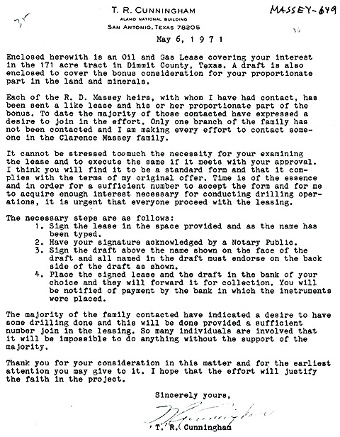
Mr.
Cunningham
issues
a
three-year lease, and a draft for the bonus money
to each of the R.D. Massey heirs.
|
10
|
6
May
1974
|
The
three-year
lease
expired.
|
11
|
31
Jan.1975
|
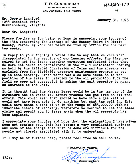
In
response
to
a
questioning letter from me, Mr. Cunningham explained that
no well had been drilled. He wrote that in Texas it is illegal to
produce gas from an oil reservoir; that the well, if drilled would have
been in the cap of an oil structure; that it would have cost $85,000.
to drill a test well that could not be utilized; that the lease had
been allowed to expire.
Mr. Cunningham also wrote that after the oil reservoir has been
depleted, the R.D. Massey heirs would be free to again lease the
property for exploration.
|
11
|
5
Apr.1975
|
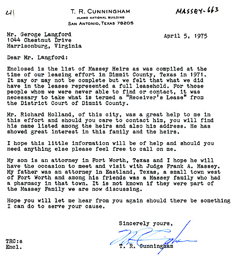
Mr.
Cunningham
sent
me
a list of the R.D. Massey heirs, as he had been
able to ascertain them. He also expressed his willingness to
again be of service in the matter of another oil lease.
|
12
|
Note 1
|
And
there
the
matter
rests; as this book is readied for publication.[1990 - Ed.]
|
|
Note 2
|
[What with the new ability of the petrogas industry to drill horizontally and open up gas fields by hydraulic fracturing of the rock at depth, Dimmit County, Texas is currently (September 2015) undergoing a natural gas play in the Eagle Ford shale - GL,III, ed.]
|
17, 18
|