Plant formerly located in Joliet, Illinois - ca. 1920.
Biplane flight over Joliet, Illinois, by George Langford, Jr., about 1917
The aerial view below, left shows the Elgin, Joliet & Eastern railroad yards in Joliet, Illinois, about 1917. As luck would have it, George, Jr.'s image also captured much of the McKenna Process Company plant on the triangular plot at right center. Image 1 and Image 2 of the main McKenna page were taken from the East Jackson Street bridge at top center. The McKenna office was located at the corner of East Jackson Street and North Abe Street. The large building on the spacious lot at bottom center of the aerial image is the Henderson School; the school and the church, both seen in the distance in Image 2, are gone now. Henderson Street is the last visible road at lower right. Then come a one-block alley and North Abe Street.
 |
The map below shows much the same area as the aerial image at left, except that North is at the top of the page in the map but about 30 degrees below left in the aerial image. The Henderson School was already gone when the USGS map was made in 1954; it was located where the "Sch" is printed on the map, just north of the stream that traverses the map. Only one building remained on the non-pink portion of the former McKenna plant site in 1954, less than ten years after the McKenna Company was liquidated; but two railroad sidings and a N/S branch line were still present. East Jackson Street is the prominent E/W road at bottom; and North Abe Street is the first N/S street to the west of the branch line. The Elgin, Joliet & Eastern railroad yards were still as prominent in this map as in the aerial image and about the same as they appeared in my April, 2005, visit to the site. 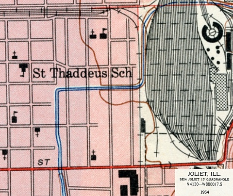 |
 The passenger in the Curtiss
J1
biplane at left was Ed Ackerman; Louis
MacLaren was pilot; and Harry Olharver was the person in the foreground. The passenger in the Curtiss
J1
biplane at left was Ed Ackerman; Louis
MacLaren was pilot; and Harry Olharver was the person in the foreground. |
 George Langford, Jr. probably
made the aerial image at upper left during his turn as passenger in
this biplane; the prints of
the images on this page all bear the same processor's ID. George Langford, Jr. probably
made the aerial image at upper left during his turn as passenger in
this biplane; the prints of
the images on this page all bear the same processor's ID. |