Cert.#
|
Images at MSA
|
Abstract, with plat descriptions from MSA images
|
Plats, by original surveyors and by using PSI-Plot
|
197
|
dsl00236-1.jpg
dsl00236-2.jpg
dsl00236-3.jpg
|
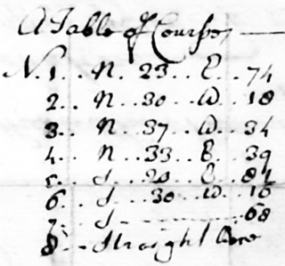
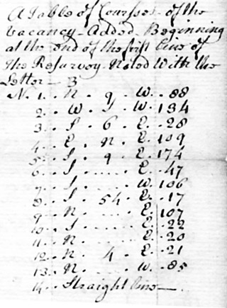
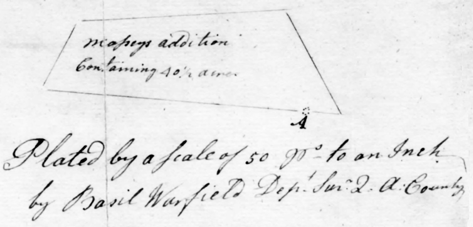
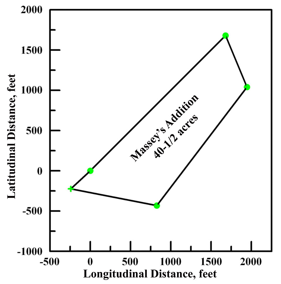
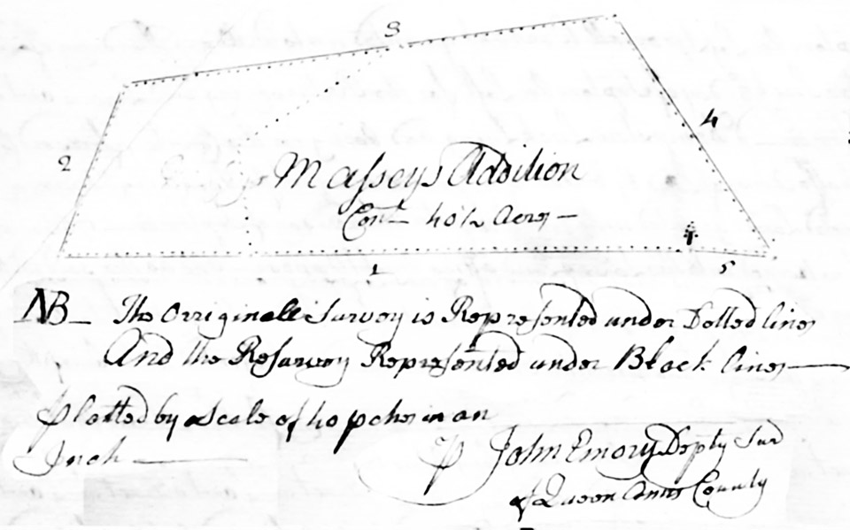
October 18, 1773: Massey's Addition: Unpatented Certificate No. 197,
40-1/2 acres surveyed for Jane Whittington. Massey's Addition was
originally granted to Samuel Massey,
who died without heirs. Jane Whittington wished to purchase the land
and petitioned to have it resurveyed, now performed by Queen Anne's
County Deputy Surveyor Basil Warfield.
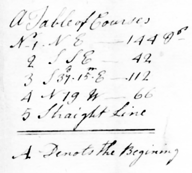 The metes and bounds of Masseys
Addition are: Beginning at a bounded post said to stand where the
original boundary of the aforesaid tract and Chestnut Neck did formerly
stand near Dividing Creek, and running from said post North East one
hundred and forty four perches, then South South East forty two perches,
then South thirty seven and a quarter degrees West one hundred and
twelve perches, then North seventy nine degrees West sixty six perches,
and from thence with a straight line to the aforesaid beginning post,
containing forty and a half acres. The metes and bounds of Masseys
Addition are: Beginning at a bounded post said to stand where the
original boundary of the aforesaid tract and Chestnut Neck did formerly
stand near Dividing Creek, and running from said post North East one
hundred and forty four perches, then South South East forty two perches,
then South thirty seven and a quarter degrees West one hundred and
twelve perches, then North seventy nine degrees West sixty six perches,
and from thence with a straight line to the aforesaid beginning post,
containing forty and a half acres.
[Note the surveyor's error in Line 3 of his Table of Courses - GL,III, ed.]
|
The land is chiefly cultivated and
has 175 panels of old rail fence.
|
|
|
198
|
dsl00237-1.jpg
dsl00237-2.jpg
dsl00237-3.jpg
dsl00237-4.jpg
|
March
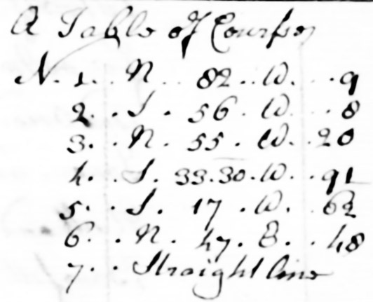
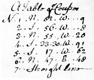
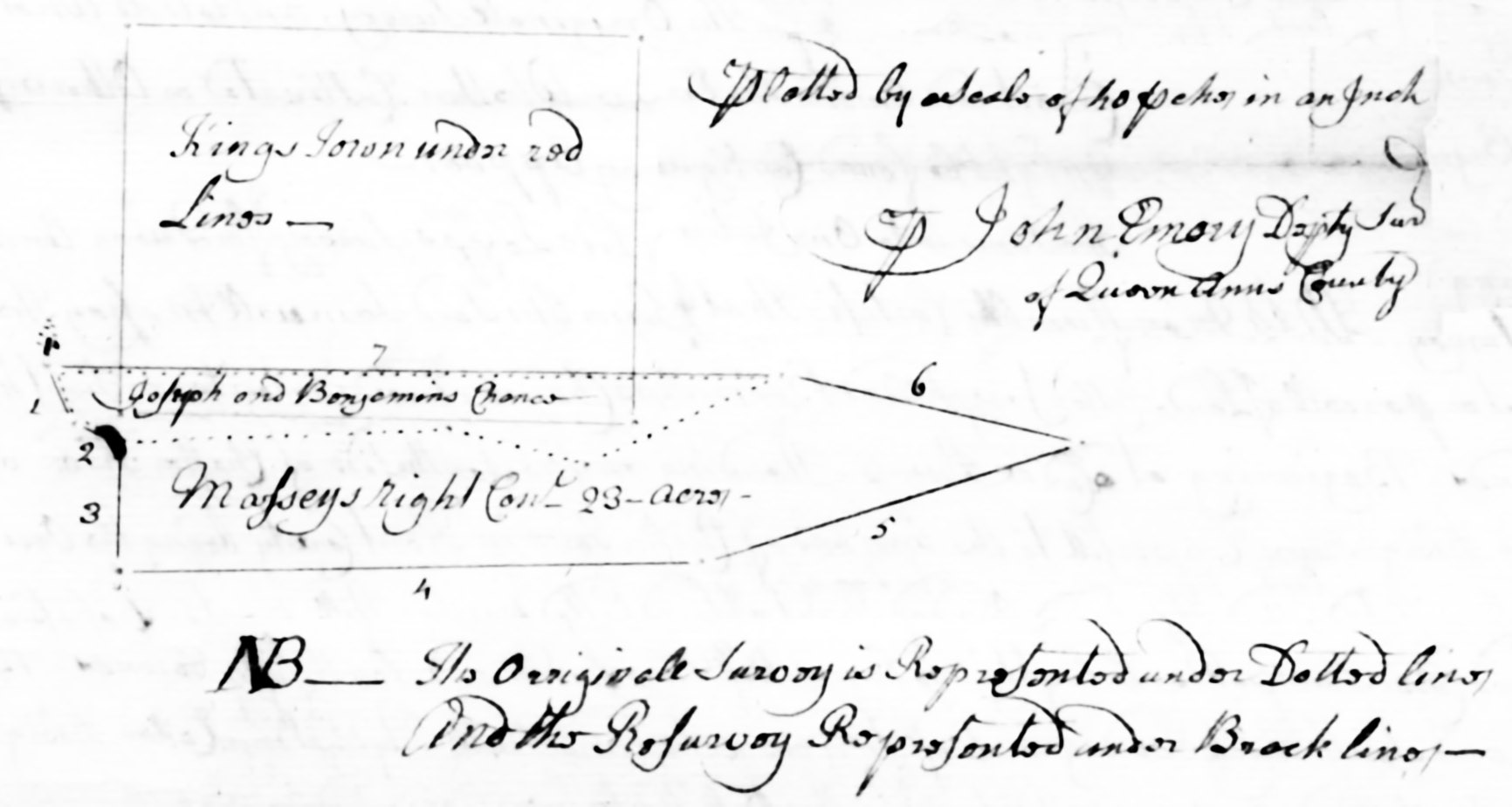
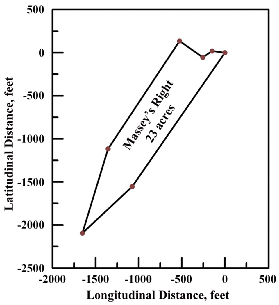
19, 1752: Masseys Right: Unpatented Certificate No.198 - 23 acres
surveyed by Queen Anne's County Deputy Surveyor John Emory for Samuel
Massey. Massey's Right is a resurvey of the tract called Joseph
and Benjamin (Whittingtons') Chance, originally laid out for 6-1/2
acres, but whose warrant had expired, nullifying the original
certificate, and which survey can now include any adjacent vacant land
found.
The ancient metes and bounds of Joseph and Benjamins Chance are:
Beginning at a cedar stump standing on the South side of Chester River
above Kings Town opposite the upper end of Chester Town in Kent County,
being the original beginning of said tract, and the second bounded tree
of a tract called Pop0lar Hill, part in possession of said Samuel
Massey,
and running from said cedar stump North eighty two degrees West nine
perches, then South fifty six degrees West eight perches, then South
thirty two degrees West fifty one perches, then South forty eight
degrees West twenty two perches, then South ten and a half degrees West
thirty four perches, and from thence with a straight line to the
beginning cedar stump, containing six and a half acres.
 For
the out bounds of the resurvey, reducing the whole into one entire
tract called Masseys Right: Beginning at the aforesaid cedar stump, and
running thence North eighty two degrees West nine perches, then South
fifty six degrees West eight perches, then North fifty five degrees West
twenty perches, then South thirty three and a half degrees West ninety
one perches, then South seventeen degrees West sixty two perches, then
North forty seven degrees East forty eight perches, and from thence with
a straight line too the said beginning cedar stump, containing twenty
three acres of land and water. For
the out bounds of the resurvey, reducing the whole into one entire
tract called Masseys Right: Beginning at the aforesaid cedar stump, and
running thence North eighty two degrees West nine perches, then South
fifty six degrees West eight perches, then North fifty five degrees West
twenty perches, then South thirty three and a half degrees West ninety
one perches, then South seventeen degrees West sixty two perches, then
North forty seven degrees East forty eight perches, and from thence with
a straight line too the said beginning cedar stump, containing twenty
three acres of land and water.
|
Four acres of this is within the bounds
of Kings Town; and on that portion are an old dwelling house,
outbuildings, etc.
... on two and a half acres, the remainder portion of the original
survey lies an old rotten house, an apple tree; and sixteen and a half
acres is vacant, water included, so that the whole resurvey contains
twenty three acres.
|
|
329
|
dsl00334-1.jpg
dsl00334-2.jpg
dsl00334-3.jpg
|
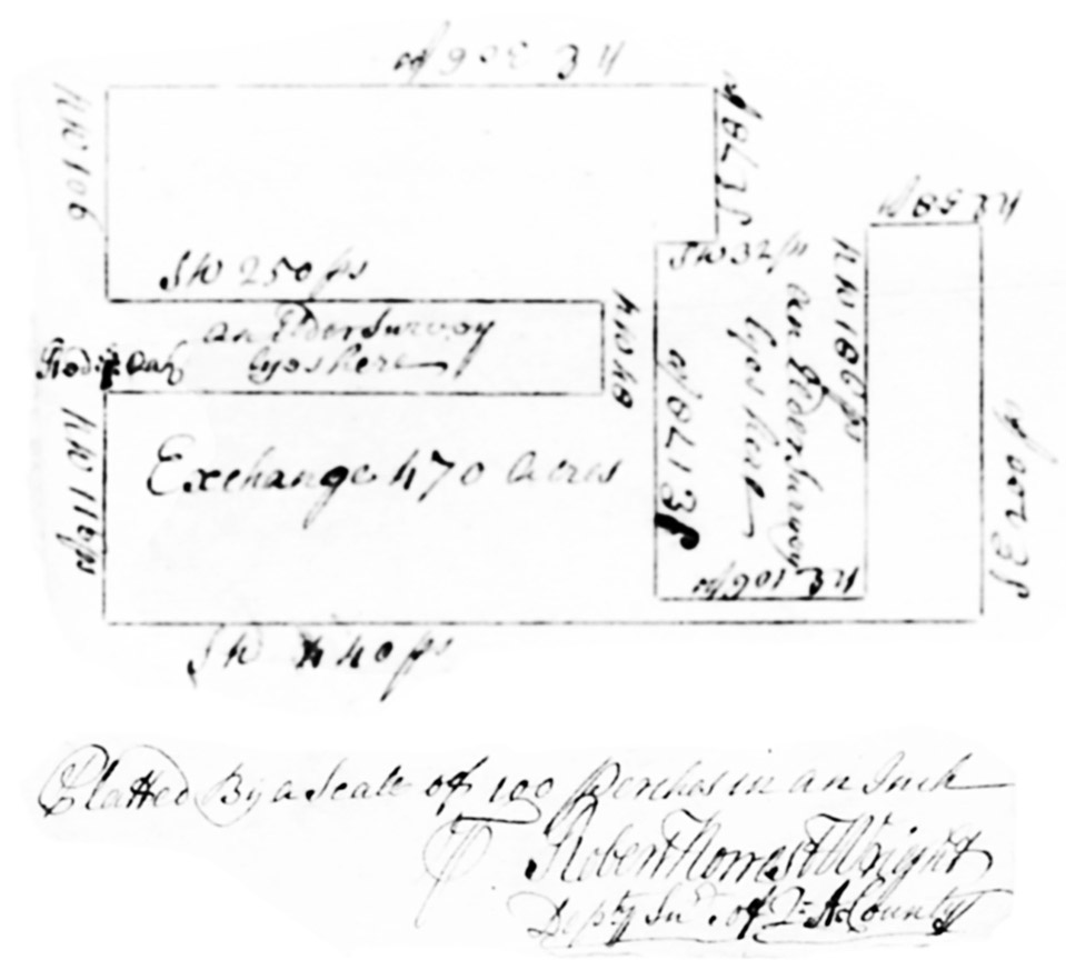
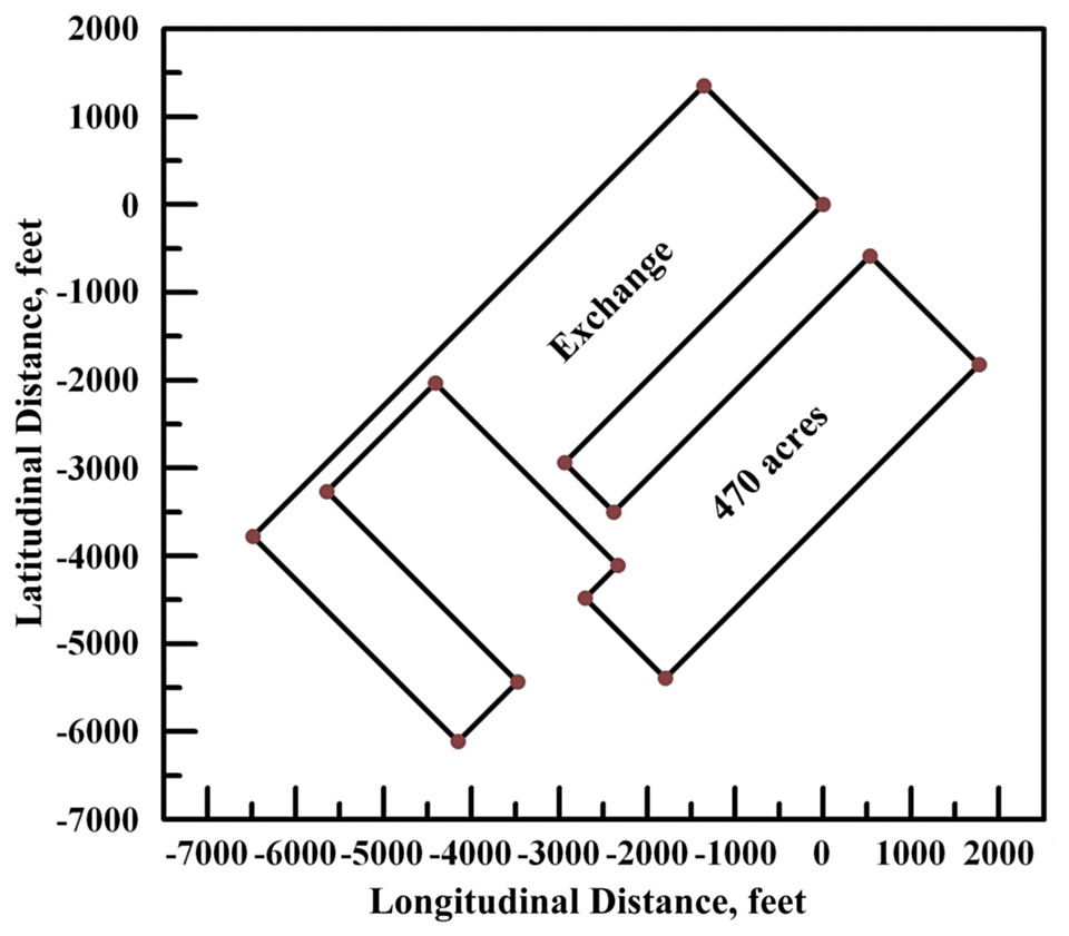
June 10, 1731: Exchange: Certificate No.329,
surveyed for Thomas Hynson Wright and patented August 15, 1735, EI:5:86,
by Queen Anne's County Deputy Surveyor Robert Norris Wright on the
branches of Island Creek.
The metes and bounds of Exchange are: Beginning at a bounded red oak
standing in or near the North West line of another tract of land called
Exchange now in possession of John Hollinsworth, and running from said
red oak North West one hundred and sixteen perches, then South West four
hundred and forty perches, then South East two hundred perches, then
North East fifty eight perches, North West one hundred and eighty six
perches, then North East one hundred and six perches, then South East
one hundred and seventy eight perches, then South West thirty two
perches, then South East seventy eight perches, then North East three
hundred and six perches, then North West one hundred and six perches,
then South West two hundred and fifty perches, then North West forty
eight perches, and from thence with a straight line to the beginning at
the aforesaid red oak, containing four hundred and seventy acres.
|
Courses
Direction
|
perches
|
NW
|
116
|
SW
|
440
|
SE
|
200
|
NE
|
58
|
NW
|
186
|
NE
|
106
|
SE
|
178
|
SW
|
32
|
SE
|
78
|
NE
|
306
|
NW
|
106
|
SW
|
250
|
NW
|
48
|
SL to
|
beg.
|
|
|
|
330
|
dsl00335-1.jpg
dsl00335-2.jpg
dsl00335-3.jpg
dsl00335-4.jpg
|
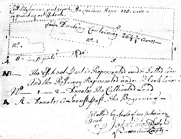
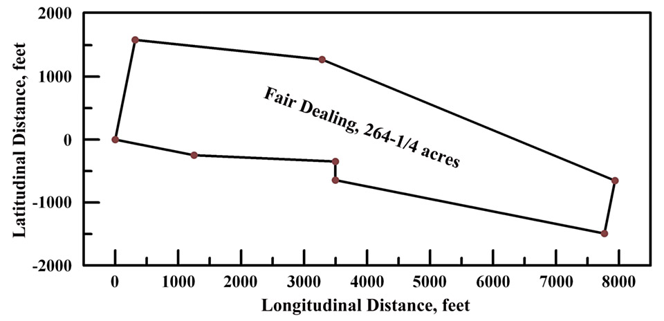
July
25, 1755: Fair Dealing: Certificate No. 330, 264-1/4 acres surveyed and
patented June 7, 1756 for Col. Richard Tilghman, BC&GS:1:413, a
resurvey by Queen Anne's County Deputy Surveyor John Emory of the tract
called Bristoll Marsh in Queen Anne's County granted unto Walter Rowles
and John Rodavoy for four hundred acres, from which three hundred and
fifty acres became the right of Walter Rowles, who died possessed
thereof without heirs, etc., the said Richard Tilghman being the first
discoverer, he thereby obtained a special warrant to resurvey the tract
and add whatever adjacent vacant land is found contiguous, whether
cultivated or otherwise.
According to its ancient metes and bounds, the tract is found lying near
the head of Corsua Creek, running out of Chester River, beginning at a
locust post standing at or near the place where stood a white oak, the
original beginning tree, by a branch called Carmens Branch, being the
second boundary of a parcel formerly laid out for Michael Powlston and
called Pauls Fort, thence running for the School part of said land North
by East ninety eight perches, then South eighty four degrees East one
hundred and eighty one perches, then North thirty eight perches, then
East South East three hundred and seven perches, then South by West one
hundred and fifty perches, and from thence with a straight line to the
beginning locust post, containing within these lines, four hundred
acres.
 The resurvey reduces the same tract and adjacent land into one
parcel now called Fair Dealing: Beginning at the aforesaid locust post
standing at or near where the original white oak stood, and running from
thence North by East ninety eight perches, then South eighty four
degrees East one hundred and eighty one perches, then East South East
three hundred and five perches, then South by West fifty two perches,
then West by North two hundred and sixty four perches, then North eighty
one perches, then North eighty seven and a half degrees West one
hundred and thirty six perches, and from thence with a straight line to
the beginning locust post, containing two hundred and sixty four and a
quarter acres. The resurvey reduces the same tract and adjacent land into one
parcel now called Fair Dealing: Beginning at the aforesaid locust post
standing at or near where the original white oak stood, and running from
thence North by East ninety eight perches, then South eighty four
degrees East one hundred and eighty one perches, then East South East
three hundred and five perches, then South by West fifty two perches,
then West by North two hundred and sixty four perches, then North eighty
one perches, then North eighty seven and a half degrees West one
hundred and thirty six perches, and from thence with a straight line to
the beginning locust post, containing two hundred and sixty four and a
quarter acres.
|
Ninety six and a half acres are now cultivated, on which
stand several [seemingly abandoned] houses & out buldings ... three
old good for nothing apple trees ... and 895 panels of old fence. The
greatest part is cut down and what remains is most part swamp and very
little [illegible]. |
|
364
|
dsl00372-1.jpg
dsl00372-2.jpg
dsl00372-3.jpg
|
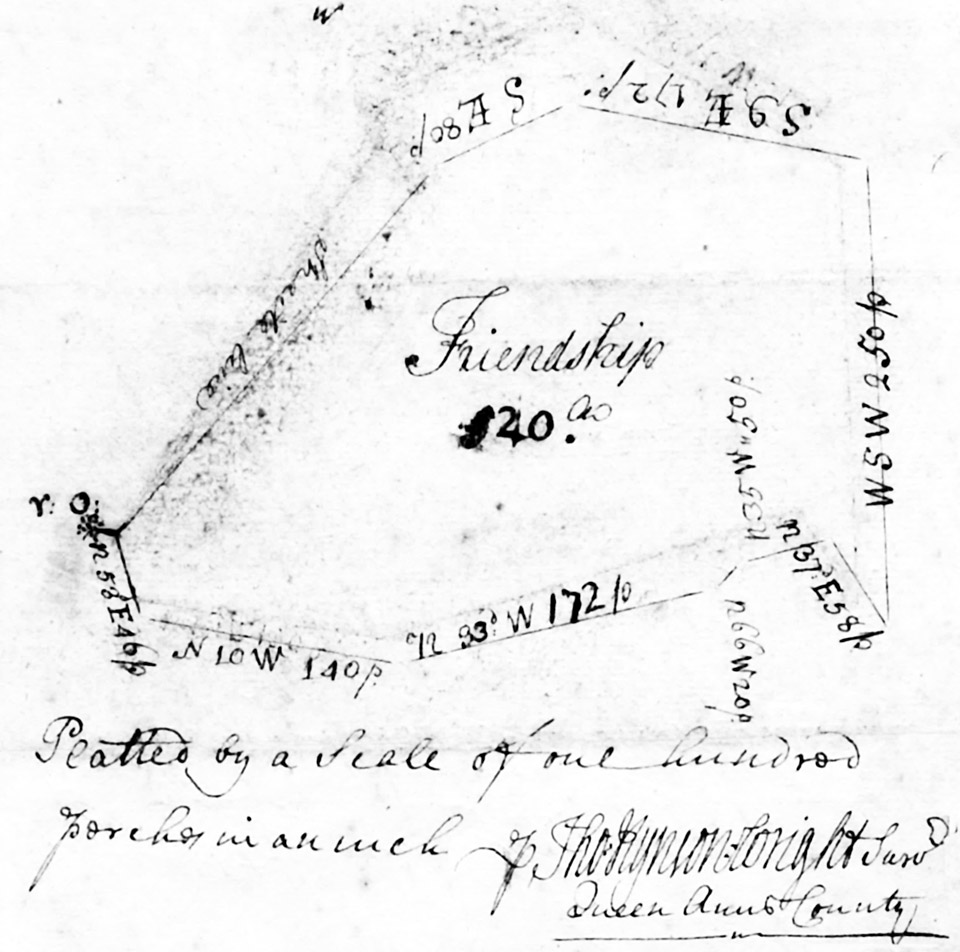
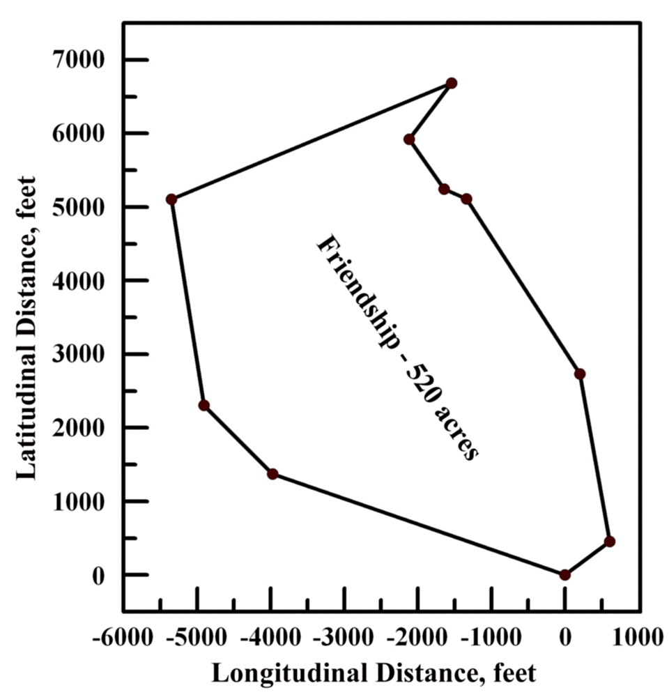
March 13, 1721: Friendship: Certificate No.364, 520 acres surveyed by
Queen Anne's County Deputy Surveyor Thomas Hynson Wright and patented
for Col. Richard Tilghman, October 10, 1732; AM:C:8.
| Friendship lies on the Southernmost side of the Unicorn Branch within
the following metes and bounds: Beginning at a bounded red oak, marked
with twelve notches, viz., four, four & four, standing by the side
of the aforesaid branch near he plantation of William Walker, and
running from said oak North fifty three degrees East forty six perches,
then North ten degrees West one hundred forty perches, then North thirty
three degrees West one hundred and seventy two perches, then North
sixty six degrees West twenty perches, then North thirty five degrees
West fifty perches, then North thirty seven degrees East fifty eight
perches [to a log ?], then West South West two hundred and fifty
perches, then South nine degrees East one hundred and seventy two
perches, then South East eighty perches, and from thence with a straight
line to the aforesaid beginning red oak, containing five hundred and
twenty acres. |
Courses
Direction
|
perches
|
N 53° E
|
46
|
N 10° W
|
140
|
N 33° W
|
172
|
N 66° W
|
20
|
N 35° W
|
50
|
N 37° E
|
58
|
W S W
|
250
|
S 9° E
|
172
|
S E
|
80
|
SL to
|
beg.
|
|
|
|
657
|
dsl00670-1.jpg
dsl00670-2.jpg
dsl00670-3.jpg
dsl00670-4.jpg
|
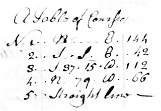
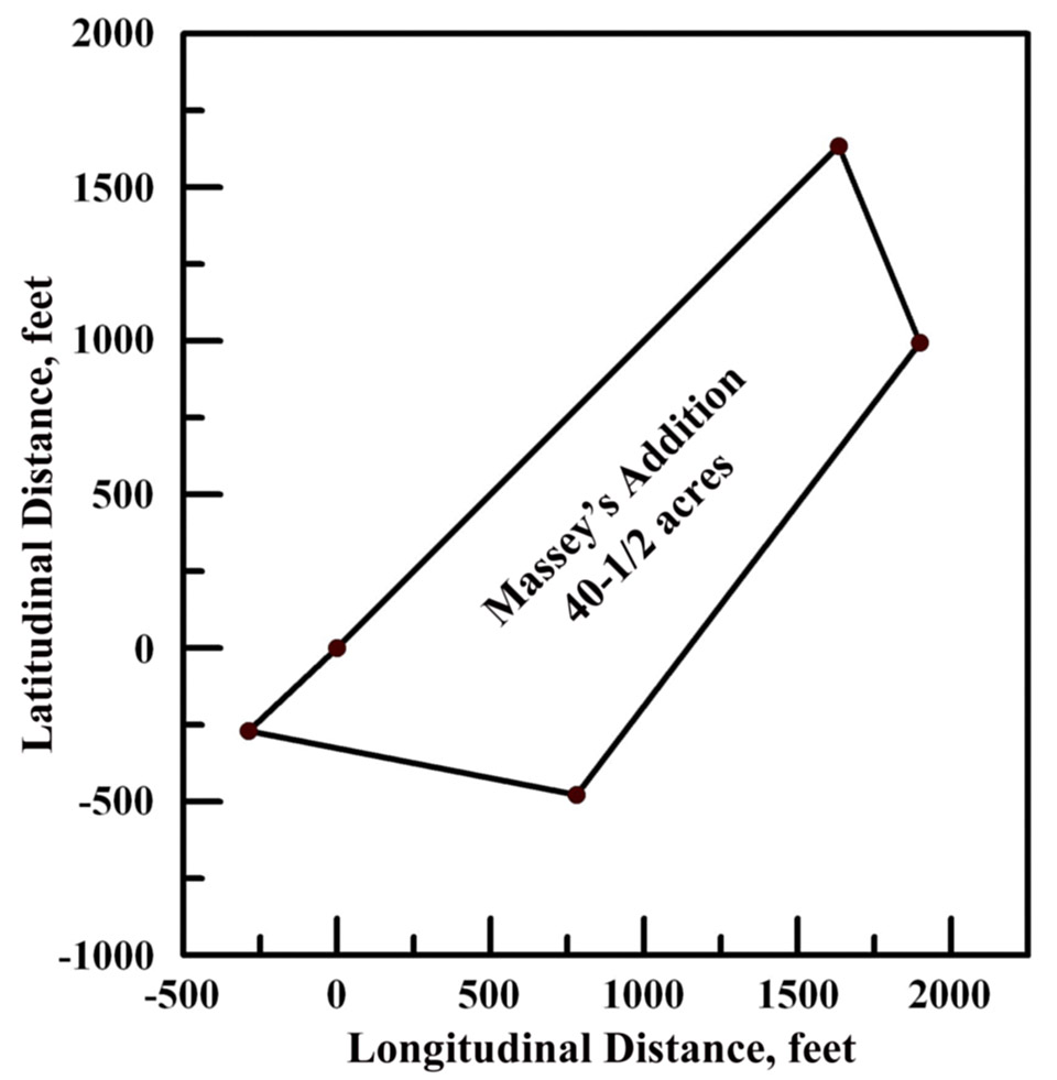
March
18, 1752: Masseys Addition: Certificate No.657, 40-1/2 acres surveyed
by Queen Anne's County Deputy Surveyor John Emory for William Durding
and patented to Samuel Massey, September 20, 1753; BY&GS:1:38, under
a special warrant to resurvey a forty and a half acre tract, including
twenty eight acres of vacant partly cultivated land, called Dempsters
Luck (whose certificate had previously been allowed to lapse by John
Dempster).
The ancient metes and bounds of Dempsters Luck are: Beginning at a
bounded red oak standing where a white oak, the original bounder of a
tract called Chestnutt Nek did stand near Dividing Creek, and running
from said red oak North East one hundred and forty four perches,
then South South East forty two perches, then South thirty seven and a
quarter degrees West one hundred and twelve perches, then North seventy
nine degrees West sixty six perches, and from thence with a straight
line to the said beginning red oak, containing forty and a half acres.
 The metes and bounds of the entire tract now called Masseys Addition
are: Beginning at the aforesaid bounded red oak standing as aforesaid
and running thence North East one hundred and forty four perches, then
South South East forty two perches, then South thirty seven and a
quarter degrees West one hundred and twelve perches, then North seventy
nine degrees West sixty six perches, and from thence with a straight
line to the beginning, containing forty and a half acres. The metes and bounds of the entire tract now called Masseys Addition
are: Beginning at the aforesaid bounded red oak standing as aforesaid
and running thence North East one hundred and forty four perches, then
South South East forty two perches, then South thirty seven and a
quarter degrees West one hundred and twelve perches, then North seventy
nine degrees West sixty six perches, and from thence with a straight
line to the beginning, containing forty and a half acres.
|
Ten acres are
cultivated and one [illegible] and other part is 260 panels of a fence
that is partly up and partly down ... broken and marshy land, little or
no timber.
William Durding subsequently sold the land and assigned the patent to
Samuel Massey for seventy five pounds of tobacco and 1/ current money of
Maryland.
Witnesses: Arthur Emory, Junior, and John Emory.
|
|
658
|
dsl00671-1.jpg
dsl00671-2.jpg
dsl00671-3.jpg
|
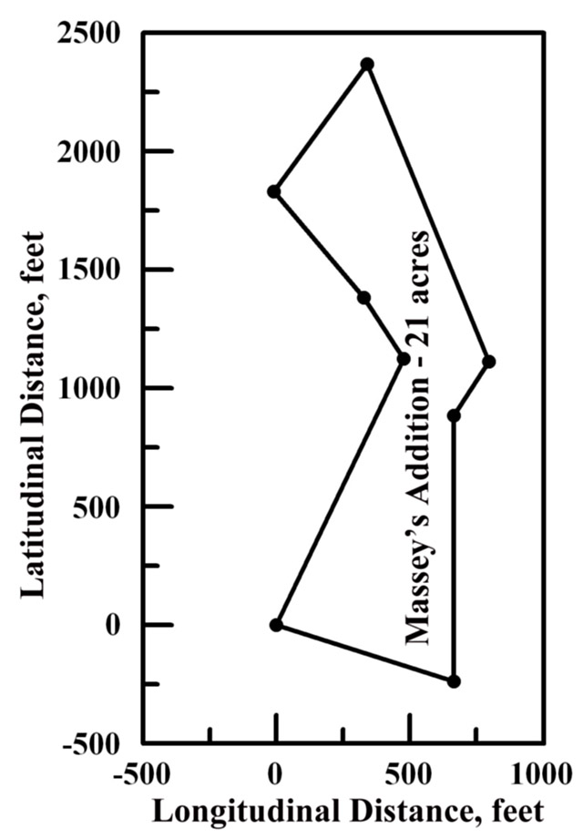
 December
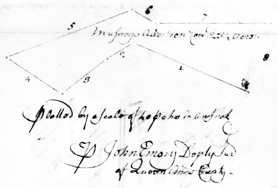
5, 1749: Masseys Addition: Certificate No.658, 21 acres surveyed and
patented December 5, 1749 for James Massey; BY&GS:5:35. December
5, 1749: Masseys Addition: Certificate No.658, 21 acres surveyed and
patented December 5, 1749 for James Massey; BY&GS:5:35.
The metes and bounds of Masseys Addition are: Beginning at a red oak
bounded with twelve notches standing on the East side of the Unicorn
Branch in a point below Hadleys Overgoing, and running from said red oak
North twenty three degrees East seventy four perches, then North thirty
degrees West eighteen perches, then North thirty seven degrees West
thirty four perches, then North thirty three degrees East thirty nine
perches, then South twenty degrees East eighty one perches, then South
thirty degrees West sixteen perches, then South sixty eight perches, and
from thence with a straight line to the said beginning red oak,
containing twenty three and a half acres.
|
|
659
|
dsl00672-1.jpg
dsl00672-2.jpg
dsl00672-3.jpg
dsl00672-4.jpg
|
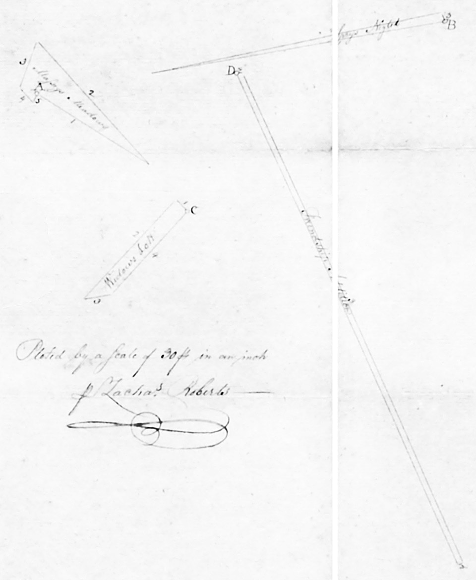
May
20, 1802: Masseys Meadows: Certificate No.659, 9-1/4 acres surveyed by
Queen Anne's County Deputy Surveyor Zacharias Roberts and patented July
26, 1803 for Hemsley Massey; JC:B:223, under a warrant to survey eight
acres of vacant land adjoining Tilghmans Friendship, Menahs Chance, and
Masseys Part of Friendship Corrected.
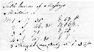 The metes and bounds of Masseys Meadows are: Beginning at the end of the
third line of Meanahs Chance and from thence running with the fourth
line thereof North thirty one degrees East fifty three perches to the
fourth line of Dungaranon, end thence with that line South forty six and
a half degrees West sixty six and a half perches to the fifth line of
Shephards Forest, and thence with that line South Seventy one degrees
East twenty perches to Shephards Forest Addition and with that line
reversed North forty seven and a half degrees East eight perches to the
third line of Meanahs Chance aforesaid and from thence by a straight line
to the first place of beginning, containing three acres, one rood and
thirty three perches of land, on which there are sixty five panels of
worm fence, worth $3. The metes and bounds of Masseys Meadows are: Beginning at the end of the
third line of Meanahs Chance and from thence running with the fourth
line thereof North thirty one degrees East fifty three perches to the
fourth line of Dungaranon, end thence with that line South forty six and
a half degrees West sixty six and a half perches to the fifth line of
Shephards Forest, and thence with that line South Seventy one degrees
East twenty perches to Shephards Forest Addition and with that line
reversed North forty seven and a half degrees East eight perches to the
third line of Meanahs Chance aforesaid and from thence by a straight line
to the first place of beginning, containing three acres, one rood and
thirty three perches of land, on which there are sixty five panels of
worm fence, worth $3. |
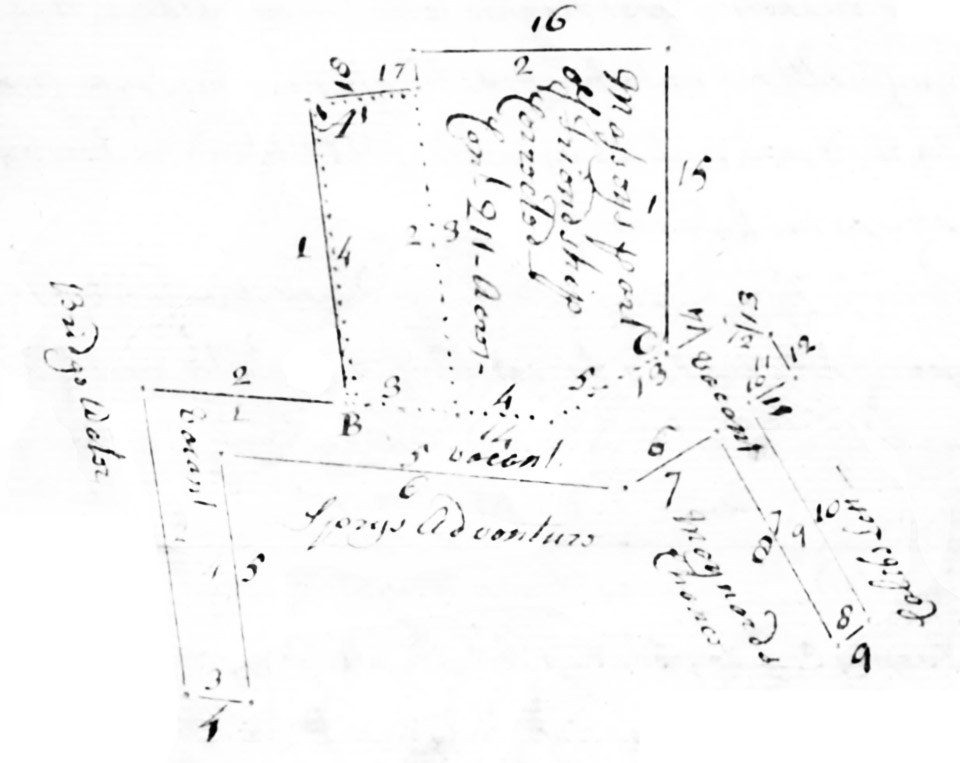
| And whereas the above quantity of land is insufficient to fill up the
aforesaid warrant, and there being other vacancies adjoining the lands
of which the said warrant is located, the following tracts of land are
herein surveyed and laid out in the name of the aforesaid Hemsley
Massey. |
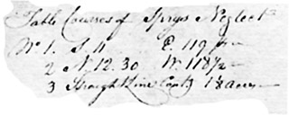 Sprys Neglect: Beginning at the end of the fifth line of Masseys Part of
Friendship Corrected and from thence running with the sixth line
thereof South seven degrees East one hundred and nineteen perches to the
fifth line of Sprys Adventure, and thence with that line reversed North
twelve and a half degrees West one hundred and eighteen and a half
perches to the aforesaid fifth line of Masseys Part of Friendship
Corrected, and from thence by a straight line to the first place of
beginning, containing one and an eighth acre. Sprys Neglect: Beginning at the end of the fifth line of Masseys Part of
Friendship Corrected and from thence running with the sixth line
thereof South seven degrees East one hundred and nineteen perches to the
fifth line of Sprys Adventure, and thence with that line reversed North
twelve and a half degrees West one hundred and eighteen and a half
perches to the aforesaid fifth line of Masseys Part of Friendship
Corrected, and from thence by a straight line to the first place of
beginning, containing one and an eighth acre. |
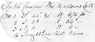 Widows Lott: Beginning at the end of the sixth line of Sprys Adventure
and from thence running with the seventh line thereof South forty four
and a half degrees West six and a half perches to the first line of
Meanahs Chance, and thence with that line South forty eight degrees East
fifty four perches to the sixth line of Masseys Part of Friendship
Corrected, and with that line reversed North eleven degrees West eleven
perches to the sixth line of Sprys Adventure aforesaid, and from thence
by a straight line to the first place of beginning, containing two acres. Widows Lott: Beginning at the end of the sixth line of Sprys Adventure
and from thence running with the seventh line thereof South forty four
and a half degrees West six and a half perches to the first line of
Meanahs Chance, and thence with that line South forty eight degrees East
fifty four perches to the sixth line of Masseys Part of Friendship
Corrected, and with that line reversed North eleven degrees West eleven
perches to the sixth line of Sprys Adventure aforesaid, and from thence
by a straight line to the first place of beginning, containing two acres. |
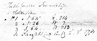 Friendship Addition: Beginning at the end of seventy five and a half
perches in the second line of Masseys Part of Friendship Corrected, and
from thence running with the seventh line reversed of Tilghmans
Friendship North sixty four degrees East two hundred and fourteen
perches, and thence North twenty six degrees West two perches to the end
of the third line of Bridge Water, and from thence with that line
reversed South sixty four degrees West two hundred and thirteen perches
to the aforesaid second line of Masseys Part of Friendship Corrected,
and from thence by a straight line to the first place of beginning,
containing two acres, two [top line(s) of certificate image missed
during archiving]. Friendship Addition: Beginning at the end of seventy five and a half
perches in the second line of Masseys Part of Friendship Corrected, and
from thence running with the seventh line reversed of Tilghmans
Friendship North sixty four degrees East two hundred and fourteen
perches, and thence North twenty six degrees West two perches to the end
of the third line of Bridge Water, and from thence with that line
reversed South sixty four degrees West two hundred and thirteen perches
to the aforesaid second line of Masseys Part of Friendship Corrected,
and from thence by a straight line to the first place of beginning,
containing two acres, two [top line(s) of certificate image missed
during archiving]. |
|
|
660
|
dsl00673-1.jpg
dsl00673-2.jpg
dsl00673-3.jpg
dsl00673-4.jpg
|
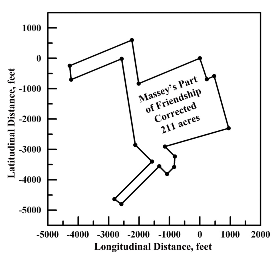
August
1, 1760: Masseys Part of Friendship Corrected: 211 acres surveyed by
Queen Anne's County Deputy Surveyor James Emory for James Massey,
Junior, and patented March 31, 1761 for James Massey, Junior;
BC&GS:14:375. James Massey has discovered vacant land adjacent to
the 115 acres of the tract called Friendship, originally patented to
Richard Tilghman and now owned by James Massey.
 The
ancient metes and bounds of the first part of Friendship are:
Beginning at a locust post marked I.M. and standing in the East North
East line of part of said tract sold by Thomas Hynson Wright to James
Massey, Senior, thence running from said locust post South twenty one
degrees East forty eight perches, then West South West one hundred and
forty two perches, then North nine degrees West forty nine perches, and
from thence with a straight line to the said beginning locust post,
containing thirty nine acres. The
ancient metes and bounds of the first part of Friendship are:
Beginning at a locust post marked I.M. and standing in the East North
East line of part of said tract sold by Thomas Hynson Wright to James
Massey, Senior, thence running from said locust post South twenty one
degrees East forty eight perches, then West South West one hundred and
forty two perches, then North nine degrees West forty nine perches, and
from thence with a straight line to the said beginning locust post,
containing thirty nine acres. |
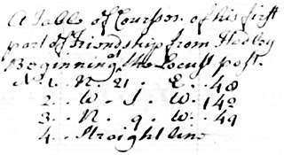
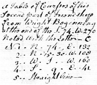 For the second part of Friendship the metes and bounds are: Beginning at
the end of the line South twenty four degrees West two hundred and
seventy perches of the said tract sold by Col. Richard Tilghman to
Francis Spry, and from thence by the line aforesaid reversed North
seventy four degrees East one hundred and thirty two perches, then North
fifteen and a quarter degrees West one hundred and eight perches, then
West South West one hundred and sixty perches, then South nine degrees
East forty one perches, and from thence with a straight line to the said
beginning, containing ninety four acres. For the second part of Friendship the metes and bounds are: Beginning at
the end of the line South twenty four degrees West two hundred and
seventy perches of the said tract sold by Col. Richard Tilghman to
Francis Spry, and from thence by the line aforesaid reversed North
seventy four degrees East one hundred and thirty two perches, then North
fifteen and a quarter degrees West one hundred and eight perches, then
West South West one hundred and sixty perches, then South nine degrees
East forty one perches, and from thence with a straight line to the said
beginning, containing ninety four acres. |
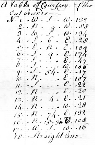 For the out bounds of the whole original tract and added vacant land the
metes and bounds of Masseys Part of Friendship Corrected are: Beginning
at the aforesaid locust post marked I.M. and standing in the East North
East line of the part of said land sold by Thomas Hynson Wright to
James Massey and running from said locust post West South West one
hundred and thirty two perches, then North nine degrees West eighty
eight perches, then West South West one hundred and thirty four perches,
then South six degrees East twenty eight perches, then East North East
one hundred and nine perches, then South nine degrees East one hundred
and seventy four perches, then South East forty seven perches, then
South West one hundred and six perches, then South fifty four degrees
East seventeen perches, then North East one hundred and seven perches,
then South East twenty two perches, then North East twenty perches, then
North four degrees East twenty one perches, then North West twenty
eight perches, then North seventy four degrees East one hundred and
thirty two perches, then North fifteen and a half degrees West one
hundred and eight perches, then West South West sixteen perches, and
from thence with a straight line to the beginning locust post,
containing two hundred and eleven acres. For the out bounds of the whole original tract and added vacant land the
metes and bounds of Masseys Part of Friendship Corrected are: Beginning
at the aforesaid locust post marked I.M. and standing in the East North
East line of the part of said land sold by Thomas Hynson Wright to
James Massey and running from said locust post West South West one
hundred and thirty two perches, then North nine degrees West eighty
eight perches, then West South West one hundred and thirty four perches,
then South six degrees East twenty eight perches, then East North East
one hundred and nine perches, then South nine degrees East one hundred
and seventy four perches, then South East forty seven perches, then
South West one hundred and six perches, then South fifty four degrees
East seventeen perches, then North East one hundred and seven perches,
then South East twenty two perches, then North East twenty perches, then
North four degrees East twenty one perches, then North West twenty
eight perches, then North seventy four degrees East one hundred and
thirty two perches, then North fifteen and a half degrees West one
hundred and eight perches, then West South West sixteen perches, and
from thence with a straight line to the beginning locust post,
containing two hundred and eleven acres. |
 One hundred and thirty three acres of this is part of Friendship; and
seventy eight acres of which is vacancy added, without cultivation or
improvements. One hundred and thirty three acres of this is part of Friendship; and
seventy eight acres of which is vacancy added, without cultivation or
improvements. |
|
|
661
|
dsl00674-1.jpg
dsl00674-2.jpg
dsl00674-3.jpg
|
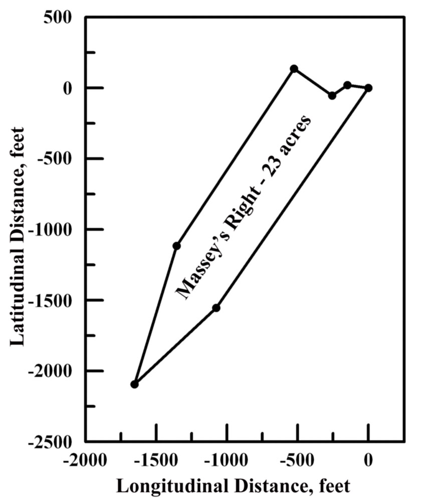
March 19, 1752: Masseys Right: 23 acres surveyed by Queen Anne's County Deputy Surveyor John
Emory for Samuel Massey and patented May 22, 1755; BC&GS:4:113. Massey's Right is a resurvey of the tract called Joseph and Benjamin
(Whittingtons') Chance, originally laid out for 6-1/2 acres, but whose
warrant had expired, nullifying the original certificate, and which
survey can now include any adjacent vacant land found.
 The ancient metes and bounds of Joseph and Benjamins Chance are:
Beginning at a cedar stump standing on the South side of Chester River
above a town called Kings Town opposite to the upper end of Chester Town
in Kent County, being the original beginning tree of said land and the
second bounded tree of a tract called poplar Hill, part in possession
of said Samuel Massey and running from said cedar stump North eighty two
degrees West nine perches, then South fifty six degrees West eight
perches, then South thirty two degrees West fifty one perches, then
South forty eight degrees West twenty two perches, then South ten and a
half degrees West thirty four perches, and from thence with a straight
line to the beginning Cedar stump, containing six and a half
acres. For the out bounds of the resurvey and reducing the entire
tract into one whole called Masseys Right, those metes and bounds are:
Beginning at the aforesaid cedar stump standing as aforesaid and running
from said cedar stump North eighty two degrees West nine perches, then
South fifty six degrees West eight perches, then North fifty five
degrees West twenty perches, then South thirty three and a half degrees
West ninety one perches, then South seventeen degrees West sixty two
perches, then North forty seven degrees East forty eight perches, and
from thence with a straight line to the said beginning cedar stump,
containing twenty three acres, four acres of which are within the bounds
of Kings Town. The ancient metes and bounds of Joseph and Benjamins Chance are:
Beginning at a cedar stump standing on the South side of Chester River
above a town called Kings Town opposite to the upper end of Chester Town
in Kent County, being the original beginning tree of said land and the
second bounded tree of a tract called poplar Hill, part in possession
of said Samuel Massey and running from said cedar stump North eighty two
degrees West nine perches, then South fifty six degrees West eight
perches, then South thirty two degrees West fifty one perches, then
South forty eight degrees West twenty two perches, then South ten and a
half degrees West thirty four perches, and from thence with a straight
line to the beginning Cedar stump, containing six and a half
acres. For the out bounds of the resurvey and reducing the entire
tract into one whole called Masseys Right, those metes and bounds are:
Beginning at the aforesaid cedar stump standing as aforesaid and running
from said cedar stump North eighty two degrees West nine perches, then
South fifty six degrees West eight perches, then North fifty five
degrees West twenty perches, then South thirty three and a half degrees
West ninety one perches, then South seventeen degrees West sixty two
perches, then North forty seven degrees East forty eight perches, and
from thence with a straight line to the said beginning cedar stump,
containing twenty three acres, four acres of which are within the bounds
of Kings Town. |
|
|
758
|
dsl00771-1.jpg
dsl00771-2.jpg
dsl00771-3.jpg
|
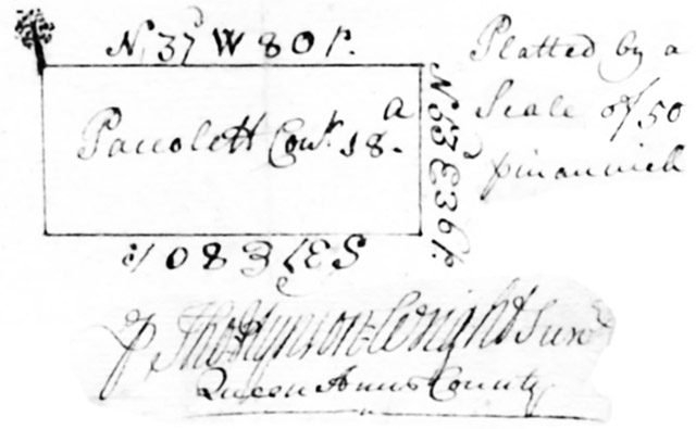
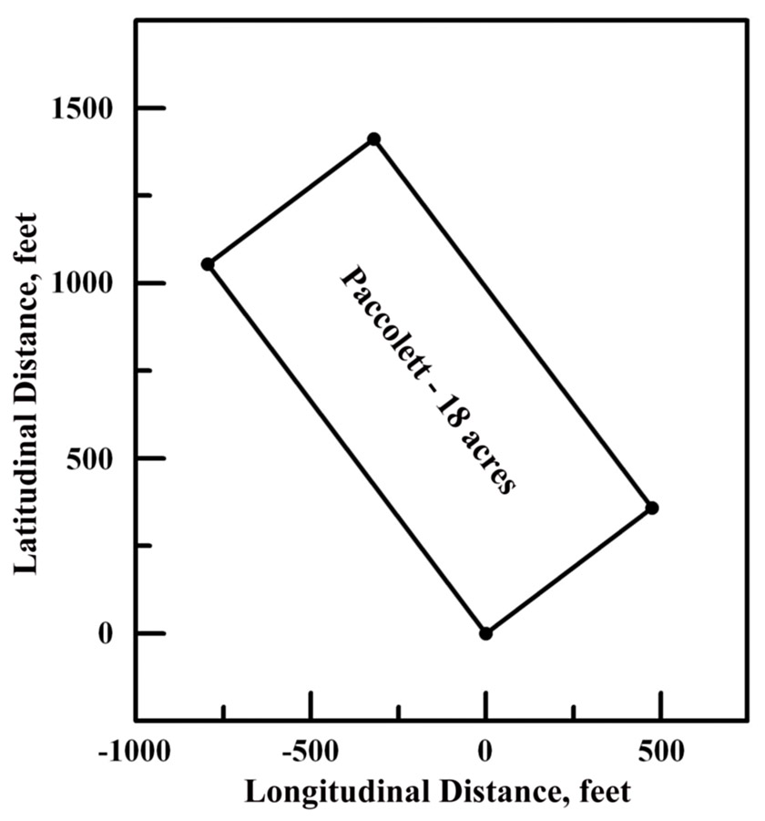
August 10, 1722:
Paccolett: Certificate No.758: 18 acres surveyed by Queen Anne's County
Deputy Surveyor Thomas Hynson Wright and patented October 8, 1728 for
William Massey; JL:B:149.
| The metes and bounds of Paccolett, lying
on the Western side of the Unicorn Branch in Queen Anne's County are:
Beginning at a bounded red oak standing near the said branch by a path
that leads from William Jackson's to William Humphrey Wellses, and
running thence North thirty seven degrees West eighty perches, then
North fifty three degrees East thirty six perches, then South thirty
seven degrees East eighty perches, and from thence with a straight line
to the aforesaid red oak, containing eighteen acres.
|
Direction
|
perches
|
N 37 W
|
80
|
N 53 E
|
36
|
S 37 E
|
80
|
SL to
|
beg.
|
|
|
|
670
|
dsl00683-1.jpg
dsl00683-2.jpg
dsl00683-3.jpg
|
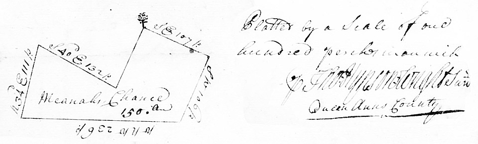
April 4, 1722:
Meanahs Chance: 150 acres surveyed and patented April 12, 1737 for
Timothy Meanah by Queen Anne's County Deputy Surveyor Thomas Hynson
Wright; EI:5:238. Timothy Meanah was granted a special warrant to
resurvey the 100 acre tract called Chance, formerly granted to Henry
Lowe, Esq. and to add to the whole any vacant land found adjacent.
| The whole tract now surveyed and tom be called
Meanahs Chance lies between Red Lyon and Unicorn Branch within the
following metes and bounds: Beginning at a bounded red oak standing upon
the North side and near the rolling road from Westump [?] Wells to
Chester River and running thence South East one hundred and seven
perches, then South West one hundred and six perches, then West North
West two hundred and thirty six perches, then North thirty four degrees
East one hundred and thirty two perches, and from thence with a straight
line to the aforesaid red oak, containing one hundred and fifty acres. |
Courses
Direction
|
perches
|
SE
|
107
|
SW
|
106
|
WNW
|
236
|
N 34° E
|
111
|
S 40° E
|
132
|
SL to
|
bg.
|
|
About a thirty acre portion is
cultivated by the said Meanah and has two small clapboard dwelling
houses and one tobacco house.
|
|
940
|
dsl00956-1.jpg
dsl00956-2.jpg
dsl00956-3.jpg
|
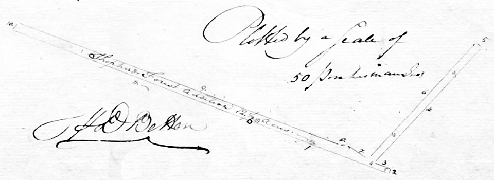
June 8, 1790:
Shephards Forest Addition: 12-1/2 acres surveyed by Queen Anne's County
Deputy Surveyor J.D. Betton and patented February 18, 1794 for Peregrine
Sudler; SC:J:310. The warrant authorizes the surveying and acquisition
of vacant land adjoining the tract called Shephards Forest.
 The metes and bounds of the vacant land, now called Shephards Forest
addition are: Beginning at the original beginning of Shephards Forest
and running thence with said land East South East one hundred perches to
a tract called Calebs Lott, and then with the same North North East
three and one half perches, then West North West twelve perches to the
beginning [illegible], then with the first line of that land North East
one hundred and six perches to Masseys Part of Friendship
Corrected, then with that land reversed North West five perches, then
South West one hundred and seven perches, then North fifty four degrees
West seventeen perches, then South eighty six and a half degrees West
four perches to the end of the second line of Maynards Chance, then with
that land West North West two hundred and thirty one and a half
perches, then South forty eight degrees West six and a half perches to
Shephards Forest aforesaid, then with that land by a straight line to
the beginning first aforesaid, containing twelve and a half acres. The metes and bounds of the vacant land, now called Shephards Forest
addition are: Beginning at the original beginning of Shephards Forest
and running thence with said land East South East one hundred perches to
a tract called Calebs Lott, and then with the same North North East
three and one half perches, then West North West twelve perches to the
beginning [illegible], then with the first line of that land North East
one hundred and six perches to Masseys Part of Friendship
Corrected, then with that land reversed North West five perches, then
South West one hundred and seven perches, then North fifty four degrees
West seventeen perches, then South eighty six and a half degrees West
four perches to the end of the second line of Maynards Chance, then with
that land West North West two hundred and thirty one and a half
perches, then South forty eight degrees West six and a half perches to
Shephards Forest aforesaid, then with that land by a straight line to
the beginning first aforesaid, containing twelve and a half acres. |
The
land is partly cultivated with 240 panels of fence worth 35/ current
money.
|
|
982
|
dsl01000-1.jpg
dsl01000-2.jpg
dsl01000-3.jpg
|
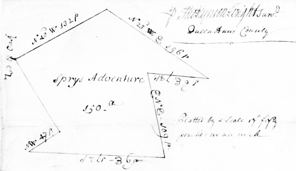
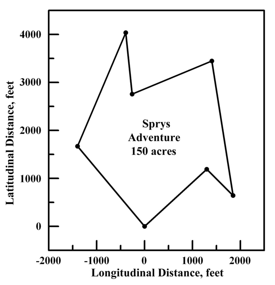
May 12, 1721: Sprys
Adventure: 150 acres surveyed by Queen Anne's County Deputy Surveyor
Thomas Hynson Wright and patented May 1, 1726 for Thomas Hynson Wright,
JL:A:233, and subsequently assigned to Francis Spry.
| Sprys Adventure lies between the Red Lyon and Unicorn Branch: Beginning
at a bounded red oak standing by the dwelling plantation of Timothy
Meanah and running thence North forty degrees West one hundred and
thirty two perches, then North twenty three degrees East one hundred
and fifty six perches, then South six degrees East seventy eight
perches, then East North East one hundred and nine perches, then South
nine degrees East one hundred and seventy two perches, then North West
forty seven perches, and from thence with a straight line to the
aforesaid red oak, containing one hundred and fifty acres. |
Courses
Direction
|
perches
|
N 40° W
|
132
|
N 23° E
|
156
|
S 6° E
|
78
|
ENE
|
109
|
S 9° E
|
172
|
NW
|
47
|
SL to
|
bg.
|
|
|
|
