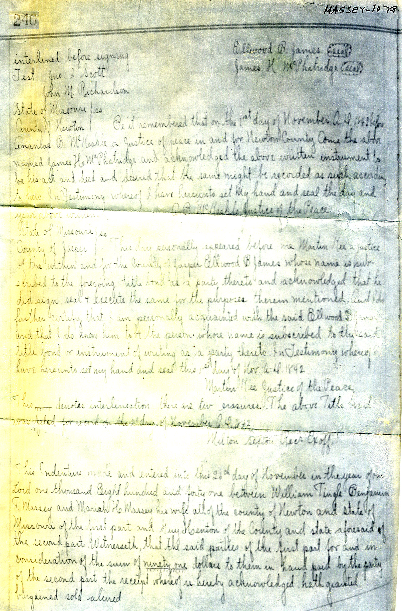
|
Source
|
The New Venture. The
Merchant - Trader partnership that Wm. Tingle and 6.Benjamin
F. Massey
had
established in the 1838-1839 period, had prospered.
Missouri had opened up State lands for sale, and the partners saw this
as an opportunity to increase that prosperity, so they entered the Real
Estate field.
|
1
|
Their
first
purchase
was
on
4 Nov. 1839, when the partnership of Tingle &
Massey was recorded as Assignees of a 160 acre Land Entry made by
Thacker Vivion.
|
3
|
Missouri: The Opening Frontier.
Let
me
insert
a
little history about the State of Missouri.
|
4
|
| In
1803,
the
United
States
made the famed "Louisiana Purchase" from
Napoleon; and in 1805 Louisiana territory was established. |
|
From
1804
to
1811,
private
claims to public lands were staked out by private
citizens; by 16 Sept. 1805, records of Land titles had been established
in St. Louis.
|
|
U.
S.
public
land
sales
were started, but they were delayed by the 1812
New Madrid earthquake, and did not really get under way until
1818. These land sales were made at the rate of $1.25 per acre.
|
5
|
In
1812,
Missouri
Territory
had
come into being, and in 1821 Missouri
became a State.
|
4
|
I
have
not
determined
when
Missouri initiated their State Survey; but it
was not until the first Quarter of 1835 that the Sarcoxie area was
surveyed; the Plat itself was not published until 8 Aug.1839.
|
6
|
Tingle & Massey: Early Plans.
They
were
well
acquainted
with the Sarcoxie area from their Merchant -
trader operations, and by 1838-1839 had selected it as an attractive
opportunity.
|
|
They
acquired
land
in
a
variety of ways.
|
|
Tingle
& Massey: Land Entries. I worked with three Land Entry
records to seek out all of those that had involved Tingle & Massey
at one time or another:
1
|
A
Purchase
Record;
at
the
Land Management Office, Department of the
Interior.
|
8
|
2
|
A
Land
Entry
Permit;
at
the State Historical Society.
|
9
|
3
|
A
Land
Entry
Index;
at
Carthage, Mo.
|
10
|
These records supplement and reinforce each other, and, when combined,
provide the details of the land transactions in which Tingle &
Massey were involved. I am not sure that I have located all of
these.
|
|
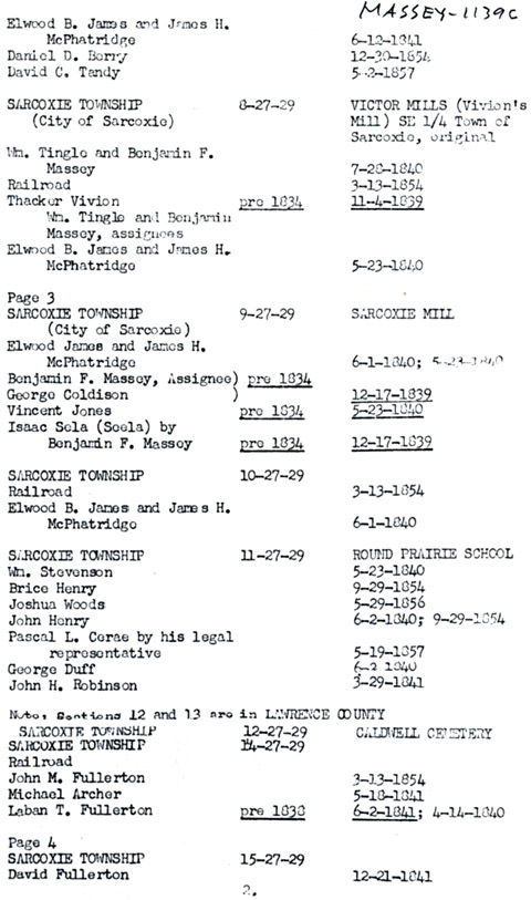
Note.
Ellwood
B.
James
and
James McPhetridge, operating as the partnership of
James & McPhetridge, were large purchasers of land during this
early Land Entry period. From my very incomplete research into
their transactions, I found at least 1,400 acres in their names.
Tingle & Massey and James & McPhetridge were involved in a
number of land transactions.
|
|
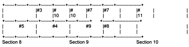
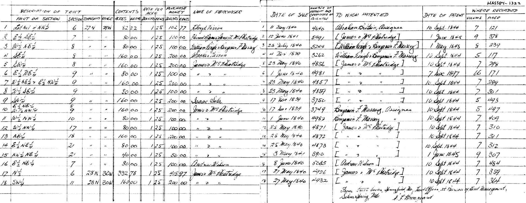
On
this
small
map,
I
show the details of the land tracts in which Tingle
& Massey eventually had an interest, in the three sections 8, 9,
and 10; in Township 27 North, Range 27 West. The town of Sarcoxie
was in the S. E. corner of Tract #4 in Section 8.
#3:
80
acres
|
#4:
160
acres
|
#5:
160
acres
|
#7:
80
acres
|
#8:
80
acres
|
#9:
160
acres
|
#10:
80
acres
|
#11:
80
acres
|
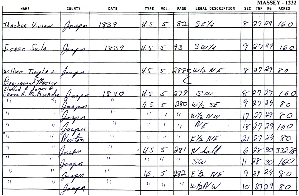
Land Entries: Listed
Chronologically:
Tract
|
Date
|
Transaction
|
#4
|
4
Nov.1839
|
Purchased
by
Thacker
Vivion,
and assigned to Wm. Tingle and Ben F. Massey.
|
#10
|
17
Dec.1839
|
Purchased
by
Ellwood
B.
James and James McPhetridge and Assigned to B.F. Massey.
|
#9
|
17
Dec1839
|
Purchased
by
Isaac
Sela,
"by B.F. Massey."
|
#5
|
23
May
1840
|
Purchased,
entered
and
patented
by Ellwood B. James & James McPhetridge.
|
#7
|
23
May
1840
|
Purchased,
entered
and
patented
by Ellwood B. James & James McPhetridge.
|
#8
|
23
May
1840
|
Purchased,
entered
and
patented
by Ellwood B. James & James McPhetridge.
|
#11
|
1
Jun.1840
|
Purchased
by
Ellwood
B.
James and James McPhetridge, and assigned to B.F. Massey.
|
#3
|
28
Jul.1840
|
Purchased,
entered
and
patented
by Wm. Tingle and B.F. Massey.
|
|
|
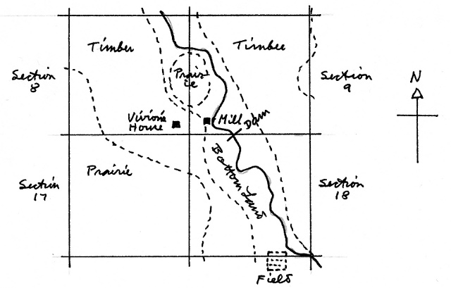
The 1835 Land Survey Maps.
I
have
several,
showing the areas around the site of Sarcoxie.
They all show the same general types of information.
|
|
For
example,
they
differentiate
between the types of land:
| Timber, Prairie, Bottom
Land, and something labelled "Barrens." |
|
|
They
show
the
rivers,
creeks, lakes, sloughs; and many springs.
|
|
On
the
36
square
mile area map of Township 27-N-Range 29-W; they show six
areas labelled "Field". Most of these fields scale 15-20 acres,
one scales about 40 acres.
|
|
Two
"Fields"
contain
a
small black square, which apparently indicates a
structure of some sort. Unanswered is the question:
| "Where did the
tillers of the other fields live?" |
|
|
"Vivion's
House"
is
the
only "House" so identified in the entire 36 square mile
area of this Township.
|
|
Township
27
North,
Range
29 West. I traced this next little map directly
from the 1835 Land Survey map; it shows the four sections surrounding
the site of Sarcoxie, which was near Vivion's house.
|
|
By
27
Nov.1841,
this Township had become known as Sarcoxie
Township. The water course is Centre Creek.
Although Thacker Vivion had drawn up a plat of a town he called
Centreville, it had not resulted in the town itself when the area
around his house was surveyed in 1835.
|
|
But,
note
that
Vivion's
house, mill and mill dam were shown on the 1835 map,
and a field, a mile or so away, that perhaps was Thacker Vivion's.
|
|
Tingle & Massey: Mill.
Perhaps
as
early
as 1838, but probably in 1839, Tingle & Massey had
purchased the Mill that Thacker Vivion had built prior to 1835:
10 Feb.1840: Newton Co.,
Mo.: "Road to Duncan's Mill on Spring river marked out --- by Tingle
and Massey's Mill and on near house of Wm. Scott --- William Duncan
made overseer."
|
|
11
|
The
record
says
that
Tingle and Massey improved and increased the grinding
facilities of the Mill, and then disposed of it. We have been
able to find no details recording this transaction.
|
3
|
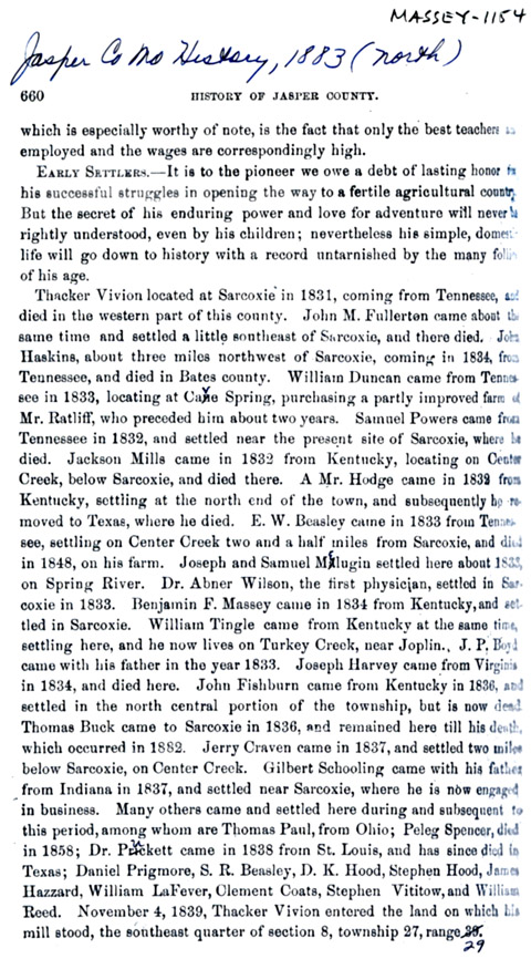
Jasper County Formation.
During
the
period
that Tingle and Massey were engaged in Real Estate
transactions, the county of Jasper was formed; here is the
chronology:
1812
|
St.
Louis
Co.
formed
as an original district of the State of Missouri.
|
1818
|
Franklin
Co.
was
set
off from St. Louis Co.
|
1820
|
Gasconnade
Co.
was
set
off from Franklin Co.
|
1829
|
Crawford
Co.
was
set
off from Gasconnade Co.
|
1833
|
Greene
Co.
was
set
off from Crawford Co.
|
1835
|
Barry
Co.
was
set
off from Greene Co.
|
1838
|
Newton
Co.
was
set
off from Barry Co.
|
1841
|
Jasper
Co.
was
set
off from Newton Co.
|
|
|
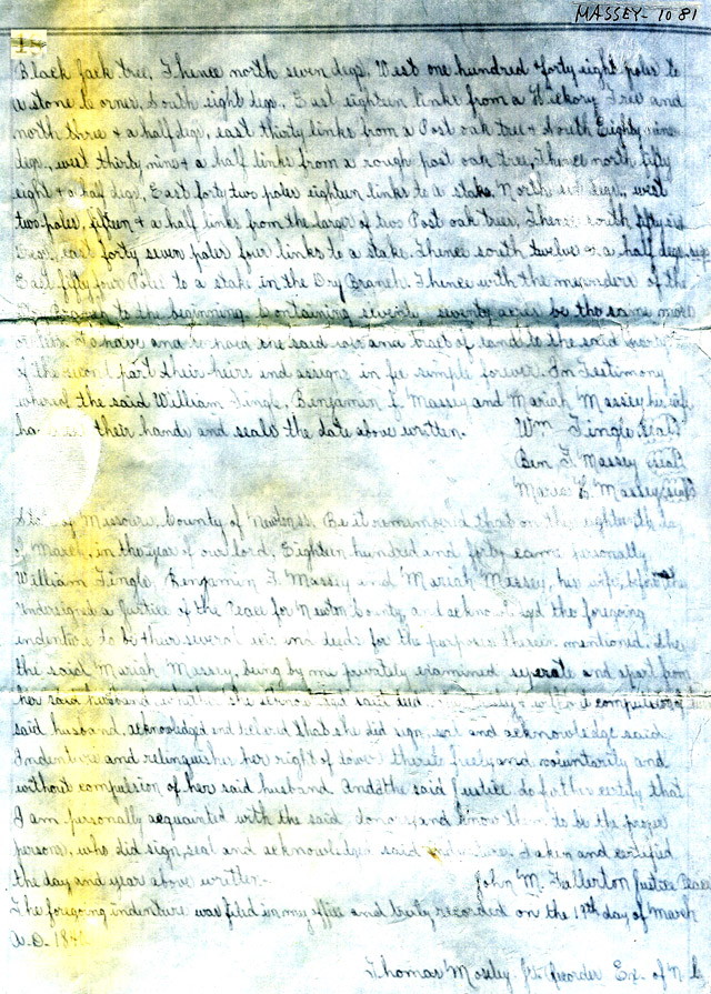
Centreville. A County
History records that Thacker Vivion platted the town of Centreville,
just North of his house, in 1834. By the first Quarter of 1835,
when the State Survey was made, the town had not yet been actually laid
out, and was not shown on the 1835 Map.
|
4; 6
|
But,
at
some
undetermined
time after 1835, Vivion Physically laid out the
town with streets and building lots; and sold some of the lots.
|
|
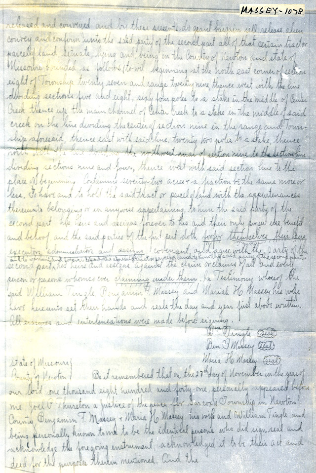
The
S.
E.
1/4th.
of Section 8, the 160 acre tract that contained the site
of Centreville was granted 4 Nov.1839 to Thacker Vivion, and assigned
to William Tingle and Ben F. Massey.
|
3
|
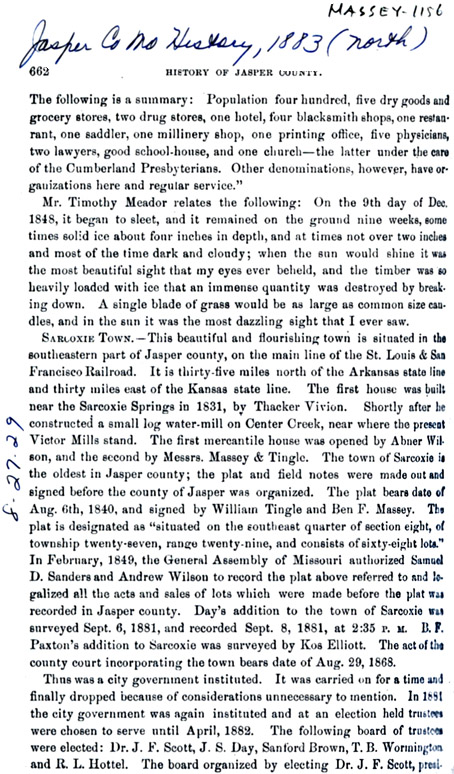
Sarcoxie. When Tingle
& Massey took over the land containing the Centreville town site,
they re-platted the town, re-naming it Sarcoxie, after a locally
well-regarded Indian chief. They recorded this Sarcoxie town plat
with a description of its 68 town lots on 6 Aug. 1840.
|
7; 12
|
The
Plat
that
they
recorded has names written in on several of the
lots. I draw the inference that these particular lots had been
sold by Thacker Vivion prior to the time that Tingle & Massey
bought the town site. Unfortunately, no record of these Lot sales
by Thacker Vivion have survived.
|
12
|
Sarcoxie Town Lot Sales.
Tingle
&
Massey
sold their first town lots in 1840; the earliest
surviving recorded Deed being dated 18 Mar.1840. The Grantors, in
these town lot Deeds, are listed variously as:- William Tingle, B. F.
Massey, Wm. Tingle & Ben F. Massey, and William Tingle, B. F.
Massey & Maria H. Massey. As Tingle & Massey were acting
as partners in these town lots sales, I attach no significance to the
varied Grantor designations.
|
13
|
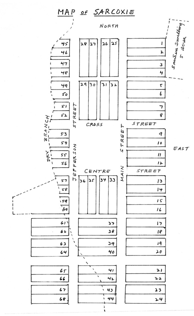
Sarcoxie Town Plat.
The Plat drawing at right is traced over the recorded Plat. On
the drawing, I show the lot numbers only, omitting the names that
appear on the recorded Plat; here are the Lot Numbers and Names:
Tract
|
Names
|
#7
|
Norris
|
#8
|
Norris;
James
Woolson;
James
Woolson.
|
#9
|
Norris;
James
Woolson;
James
Woolson.
|
#10
|
Edward
I.
Dillon.
|
#11
|
Edward
Bredell;
Edward
Dillon;
Edward Dillon.
|
#17
|
Heirs
of
Fishburn.
|
#18
|
Heirs
of
Fishburn.
|
#25
|
Moses
L.
Baker;
Moses
Baker; James Woolson.
|
#26
|
Moses
L.
Baker;
Moses
Baker; James Woolson.
|
#27
|
Ellwood
James
&
James
McPhetridge.
|
#28
|
Ellwood
James
&
James
McPhetridge.
|
#29
|
McCurdy;
James
&
McPhetridge.
|
#30
|
McCurdy;
James
&
McPhetridge.
|
x#31
|
Tilton
& Sanders;
Moses
L. Baker; Moses L. Baker; James Woolson.
|
#32
|
Tilton
& Sanders;
Moses
L. Baker; Moses L. Baker; James Woolson.
|
#33
|
Heirs
of
Fishburn;
Edward
I. Dillon; Edward Bredell; Edward Dillon; Edward
Dillon.
|
#34
|
A.
Wilson;
A.
Wilson;
David Guthrie.
|
#35
|
A.
Wilson;
A.
Wilson;
David Guthrie.
|
#36
|
James
& McPhetridge;
James
& McPhetridge;
|
I have underlined the names that are written on Lots on the recorded
Plat, the lots that appear to have been sold by Thacker Vivion.
The other Grantee names are for sales made by Tingle & Massey.
|
12
|
The
Deeds
recording
these
Lot sales are very confusing; they read as though
the lots had been bought and sold several times; as indeed may have
been the case. There may be missing Deeds and unrecorded Deeds
that would make it difficult to trace Lot ownership trails. As I
was unable to solve this ownership confusion, I simply listed the
various Lot owners, as they appear in surviving records.
|
|
Note
that
the
Lots
with the busiest sales patterns were those that faced on
the Town Square:
#9 to #13 on the East side.
|
#29 to #32 on the North.
|
#53 to #56 on the West.
|
#33 to #36 on the South.
|
There is one interesting deviation from these Town Square Lot sales:
|
|
Lots
#34
and
#35
are in the name of A. Wilson, who was, no doubt, the Andrew
Wilson who is recorded as the owner of the first Mercantile House
partnership venture.
|
1
|
It
is
very
tempting
to surmise that Tingle & Massey reserved Lot #12
for themselves, from which to launch their own Mercantile House
partnership venture.
|
1
|
The
Book
of
Plats
contains this description as a part of the recorded Plat:
"The streets are forty
feet wide. There is also two alleys running from east to west 14
feet wide ... all the alleys dividing blocks are 8 feet wide.
Lots numbered 1, 2, 3, 4, 5, 6, 7, 8 are (50) fifty feet front and two
hundred feet deep. Lots numbered 9, 10, 11, 12, 33, 34, 36, 29,
30, 31 and 32 facing the Square are to be as deep as each Four Lots
fronting the square including the alleys and the front of lots fronting
the Square as above mentioned are to be equal lots numbered 45, 46, 47,
48, 49, 50, 51, 57, 58, 59 and 60 each front fifty feet and do not
extend further back than a certain stream known as the "Dry
Branch". Lots number 53, 54, 55 and 56 fronting on the Square on
the west, run back only to the "Dry Branch" and are to front each
equally on the Square. All of the balance of the lots --- are to
front fifty feet and run back in depth two hundred feet."
|
|
12
|
This
original
town
is
shown on modern maps of the town of Sarcoxie.
Centre Street became Center Street. Main Street became Fifth
Street. Jefferson Street is now Sixth Street. Modern Church
Street was the old Un-named street between Lots #20 and #21.
|
|
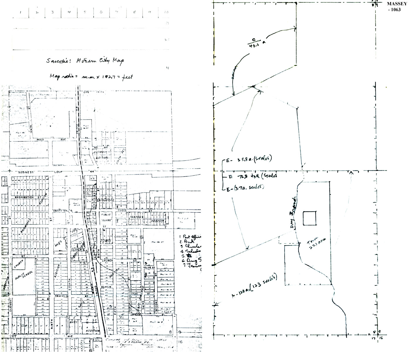
Tingle & Massey: Real Estate
Domain: Early 1840's. As best I can tell, from the records
at my disposal, Tingle & Massey arrived at the peak of their
success in their Real Estate venture in the early 1840's.
|
|
Although
Thacker
Vivion
had
actually platted the town, laid out streets and
building lots, and even sold some of the lots; when Massey & Tingle
assumed its ownership, they re-platted the town, changed its name from
Centreville to Sarcoxie; Tingle & Massey are regarded as the
Founders of the town of Sarcoxie.
|
|
From
the
date
that
they first became involved in Land Entries in South-West
Missouri, until the early 1840's, they must have made many land
transactions; but from the records I could find, I was unable to follow
the trail of these transactions. So, in order to illustrate their
domain, I took another approach.
|
|
I
worked
backwards
in
time from the accurately recorded Deed resulting
from the Powell lawsuit; and the large Tingle & Massey acreage
sales in 1840 and 1841. Here is how I went about it:
Town of Sarcoxie: cs. 22
Acres: I positioned it to scale in the S.E. 1/4th. of Sec. 8,
from a modern map of the town, which shows the "Original Town."
|
14
|
Tract E.: 72.8
Acres. The "beginning" of the Surveyor's description of this
Tract is a point just West of the S.W. corner of the Sarcoxie Town
Square. I followed the surveyor's description of this Tract, to
scale. Although the surveyor calls the acreage 70 acres, it
actually scales about 72.8 acres.
|
13
|
Tract C: 40 Acres:
The Deed gives no hint of the shape of this tract, so I took the
liberty of drawing in the proper acreage to fit against Tract E and the
N.W. corner of the N.E. 1/4th. of Section 8.
|
15
|
Centre Creek. I drew
to scale from the 1835 Survey of Township 27 North, Range 29 West,
which later became known as Sarcoxie Township.
|
6
|
My modern map of the town
of Sarcoxie does not show the location of Center Creek, so my drawing
of Center Creek does not position it as accurately as I would
like. But, I had to locate the position of the Creek as best I
could, because the Surveyor's description of Tract F depends on
the location of Center Creek.
|
|
Tract F: 72.1 Acres.
Starting with the "beginning" point of the Surveyor's description, I
followed the Deed.
|
18
|
Tract D: 88 Acres.
The East boundary of this Deed is defined as Center Creek. But my
positioning of the West boundary is strictly my best guess.
|
15
|
Tract A: 123 Acres.
The Powell Deed calls this a 120 acre tract. But I scale it as
about 123 acres.
|
15
|
Tract B; 160 Acres.
No problem here; it is the 160 acre Tract, as described in the Powell
Deed.
|
15
|
Tract X: 4.1 Acres.
As I drew this map of the Tingle & Massey peak Real Estate domain,
it appeared rather obvious that it was composed of Land Entry Tracts #3
and #4 and half of #10, all in Section 8; and Tract #9 and half of #10,
both in Section 9.
|
|
Tract X is the unexplained
left-over in the half of Tract #10 in Section 9.
|
|
I am reasonably well satisfied with this map; although I am sure that
some one else, with more and better records at hand and the time and
energy required, could do a better job. |
|
| The Tingle & Massey Real
Estate Venture Ends.
After the sale in 1840 of Tract E; and in 1841 of Tract F; the Tingle
& Massey Real Estate domain had been reduced to Tracts A, B, C and
D. |
|
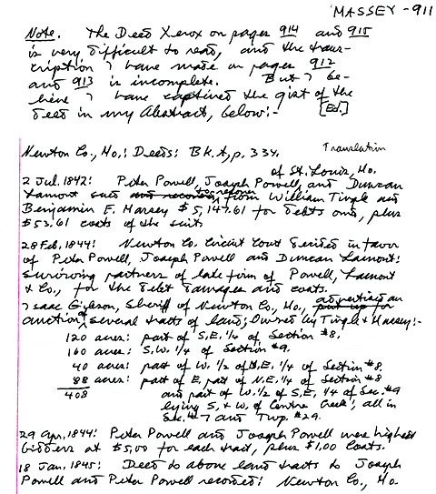
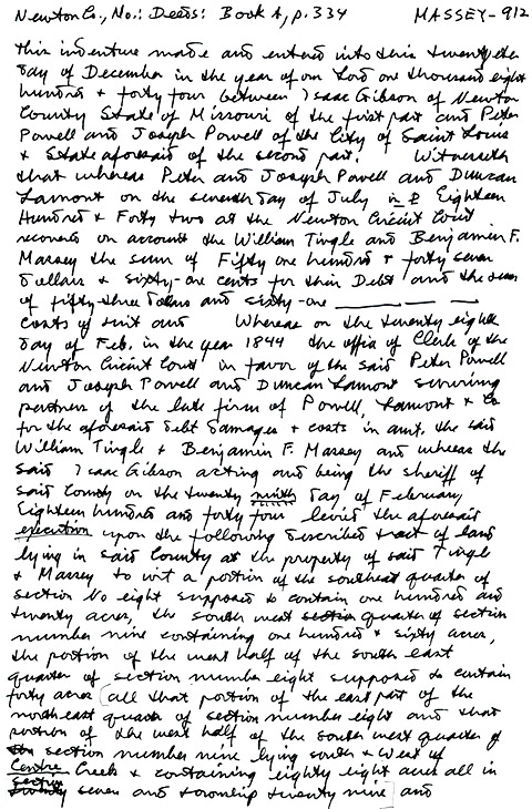
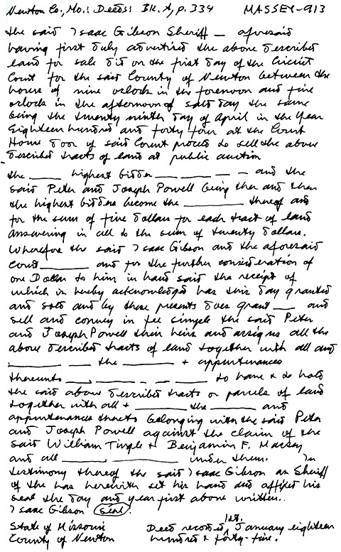
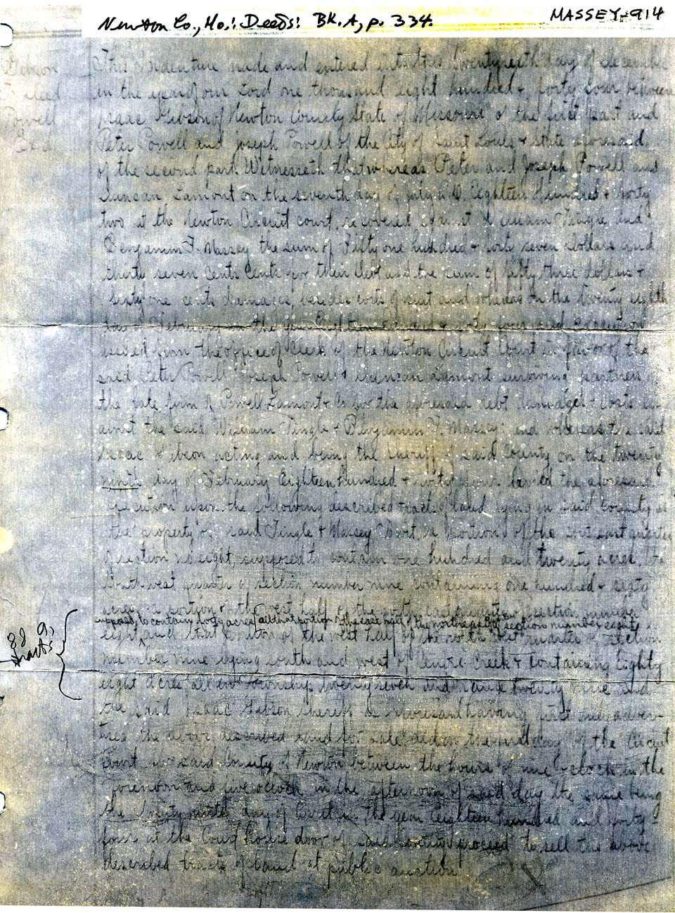
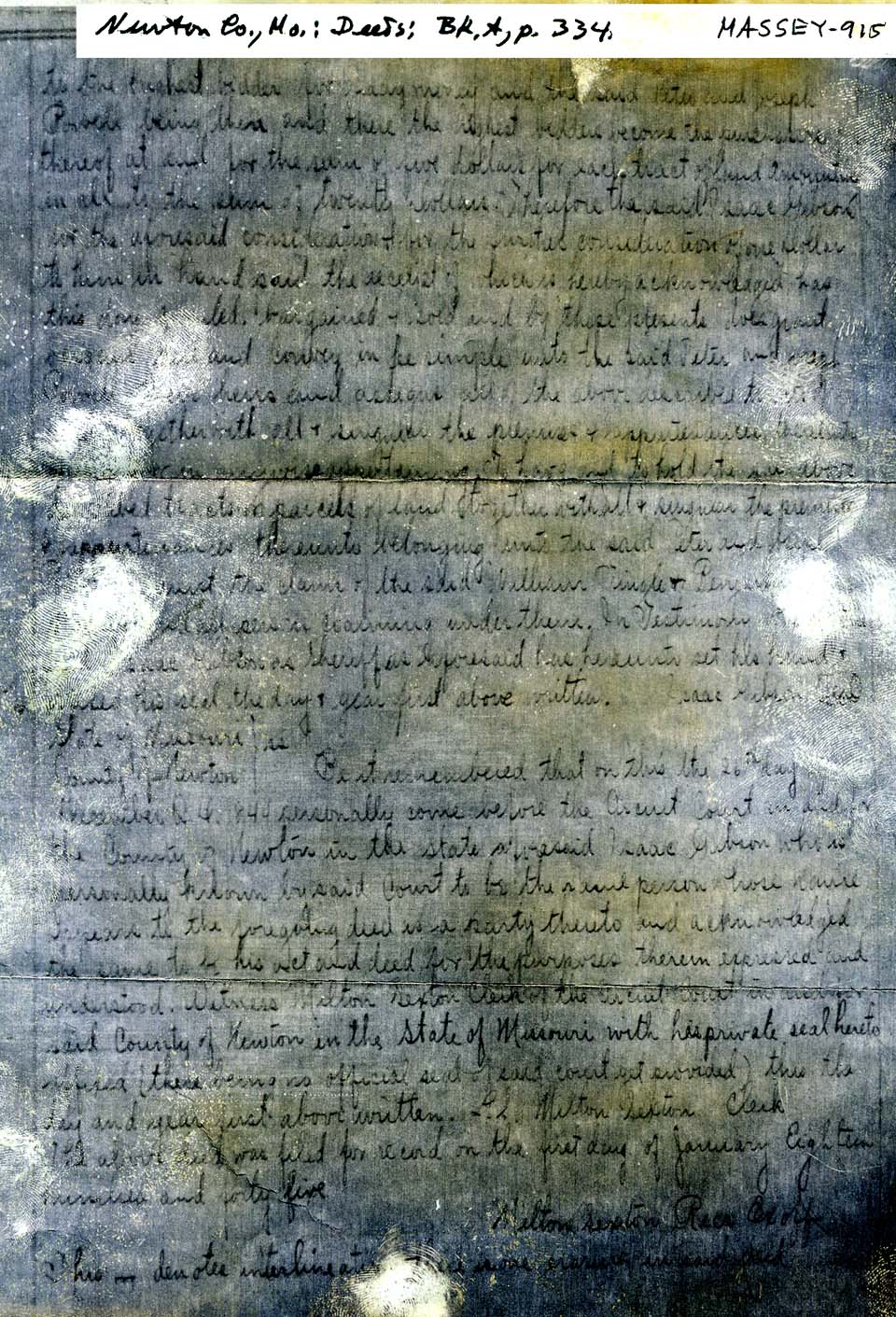
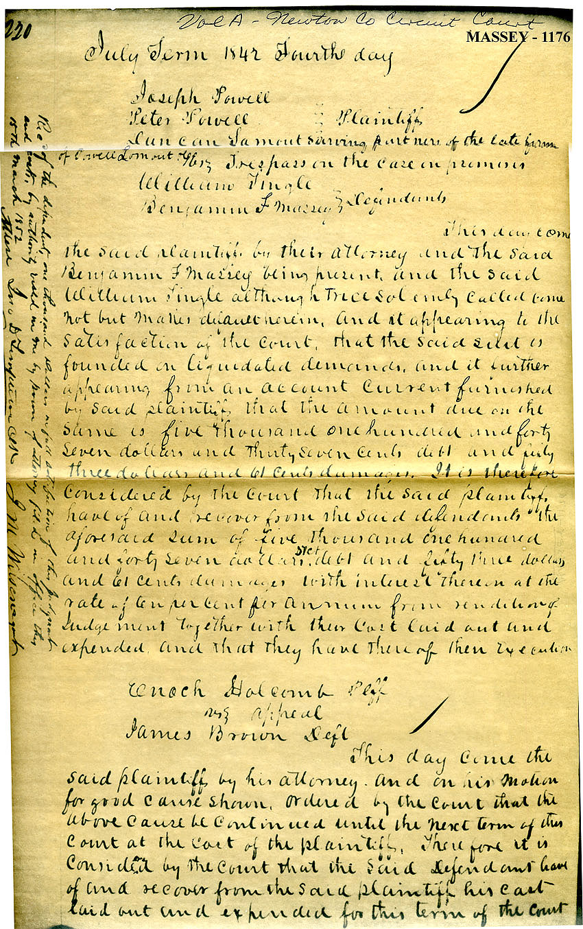
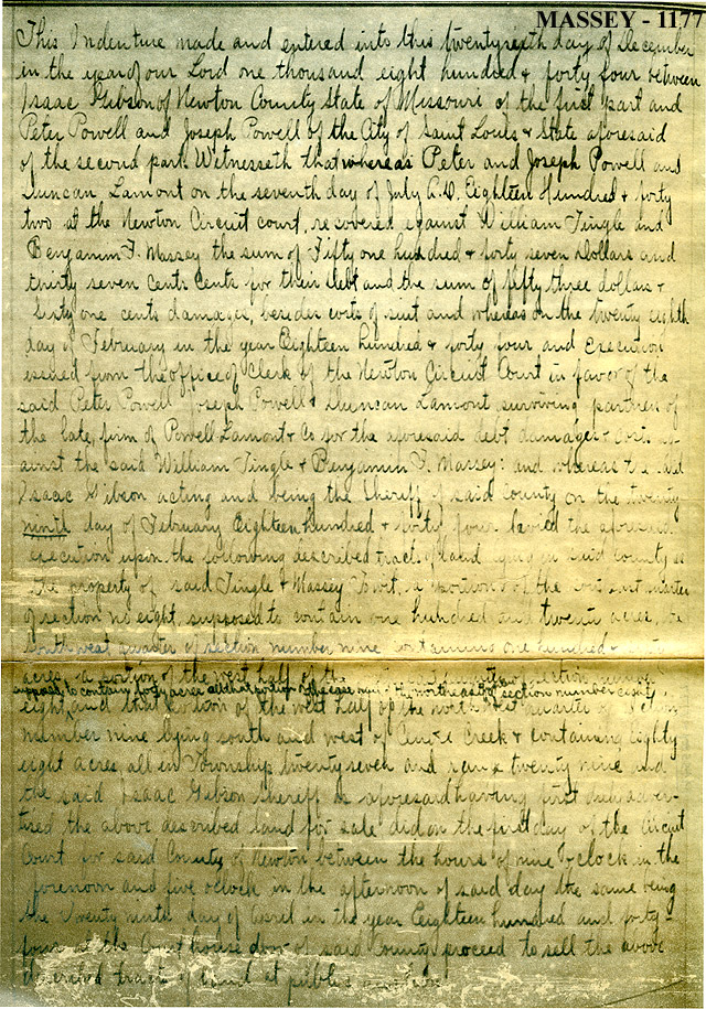
The
Lawsuit
that
the
Powell brothers had filed, back on 2 Jul.1842 had
been decided, 28 Feb. 1844, by the Newton County Circuit Court in favor
of the Powells. To satisfy the $5,147.37 Judgment, the Court
ordered sold at auction Tract A of 120 acres, Tract B of 160 acres,
Tract C of 40 acres,and Tract D of 88 acres.
|
16; 15
|
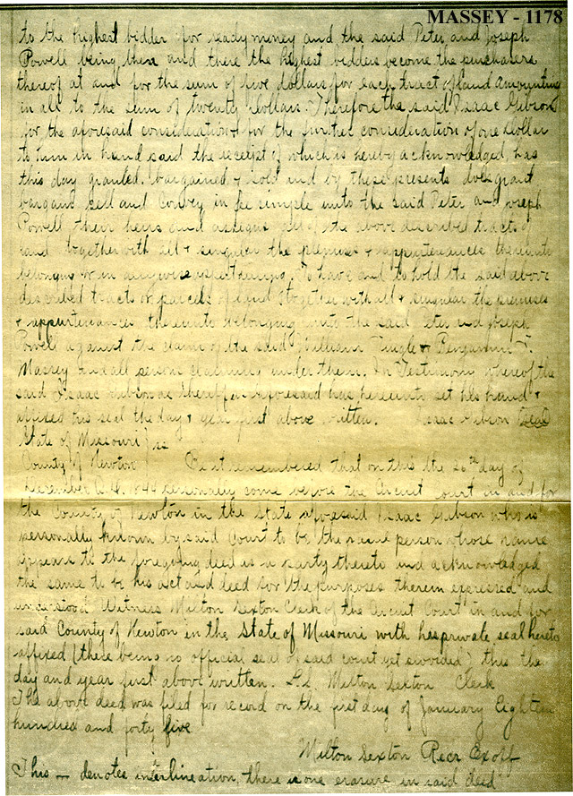
Joseph
and
Peter
Powell
were the high bidder, paying $20.00 total to secures
title to the four tracts. The Powells recorded the Deed to these
four Tracts 18 Jan.1845.
|
16; 15
|
As
the
Tingle
&
Massey Mill had been disposed of at some earlier date,
this 28 Feb.1844 auction signalled the sad end of the Tingle &
Massey Real Estate ventures.
|
|
Town Lot Sales Legalized.
The
Missouri
Legislature
enacted a Bill, dated 5 Feb.1849, authorizing
Samuel D. Saunders and Andrew Wilson to record the Sarcoxie Plat that
Wm. Tingle and Ben F. Massey had signed 6 Aug.1840; and this later
Plat was recorded in Jasper Co., Mo., 27 Mar.1849.
|
12
|
As
duly
elected
clerk
of the Missouri House of Representatives, this Bill
was attested by Ben F. Massey.
|
12
|
I
have
not
researched
what disposition the Powells made of their Town
Lots and other Land Tracts that they bought at auction. Perhaps
the 1849 Act was needed to confirm Title to Samuel D. Saunders and
Andrew Wilson, so they could record the Sarcoxie town plat.
|
|
Concluding Transaction.
Written
on
the
margin of the last page of the 28 Feb. 1844 record of
the Powell suit against Tingle & Massey, was this notation, dated
15 Mar.1852:
"Recd. of the
defendent[sic], one thousand dollars in full satisfaction of the
Judgment and costs, by authority vested in me by Power of attorney,
filed in office this date. J. M. Wirsena, Gent. Attest. Jno. B.
Limption, Clk."
|
|
|
Unfortunately,
the
name
of
the payer of the $1,000. is not spelled out, so we do not
know for sure that this notation applies to the Powell Lawsuit.
The 1852 date appears logical; the notation is on the same sheet of
paper and tight up against the Lawsuit record. But we are not
positive.
|
|
Profit or Loss?
Missouri Land Entry sales were made at the rate of $1.25 per acre in
1839 and 1840. In 1841, Tingle & Massey Tract F sold at
$1.25. Assuming that the $1.25 acreage price still prevailed at
the peak of their venture, they owned 560 acres, worth about $700.00;
plus an unknown number of Town Lots, value unknown; plus the Tingle
& Massey Mill, value also unknown. Actually, to put a value
on their holdings would be sheer guesswork, and I don't feel qualified
to make even a wild guess.
|
|
There
are
no
figures
to help us determine whether the Tingle & Massey
Real Estate ventures were, or were not, profitable.
|
|
But,
as
I
read
between the lines of the Powell Suit and the wording of
various Deeds, I cannot escape the opinion that these ventures did not
turn a profit. More likely a loss, very probably a substantial
loss, financially tragic to both William Tingle and B.F. Massey.
|
|